
Erode District is one of the 38 districts in the state of Tamil Nadu in India. It was the largest district by area in the state before the formation of Tirupur District in 2009. The headquarters of the district is Erode. It is divided into two revenue divisions, Erode and Gobichettipalayam, and is further subdivided into 10 taluks. Erode District was a part of Coimbatore District before its division into two on 17 September 1979. It covers an area of 5,722 square kilometres (2,209 sq mi), and as of 2011, had a population of 2,251,744.

Sathyamangalam is a town and municipality in Erode district in the Indian state of Tamil Nadu. It lies on the banks of the Bhavani river, a tributary of the Cauvery in the foothills of the Western Ghats and is the headquarters of Sathyamangalam taluk. It is about 65 km from Erode, 58 km from Tiruppur and 65 km from Coimbatore. As of 2011, the town had a population of 37,816.

Gobichettipalayam is a town and municipality in Erode district of the Indian state of Tamil Nadu. It is the administrative headquarters of Gobichettipalayam taluk. It is situated at the center of the South Indian Peninsula at 213 metres (699 ft) above sea level, surrounded by Western Ghats. It is located 35 kilometres (22 mi) from the district headquarters Erode, 44 kilometres (27 mi) from Tiruppur and 80 kilometres (50 mi) from Coimbatore. Agriculture and textile industries contribute majorly to the economy of the town.

Coimbatore district is one of the 38 districts in the state of Tamil Nadu in India. Coimbatore is the administrative headquarters of the district. It is one of the most industrialized districts and a major textile, industrial, commercial, educational, information technology, healthcare and manufacturing hub of Tamil Nadu. The region is bounded by Tiruppur district in the east, Nilgiris district in the north, Erode district in the northeast, Palakkad district, Idukki district and small parts of Thrissur district and Ernakulam district of neighboring state of Kerala in the west and south respectively. As of 2011, Coimbatore district had a population of 3,458,045 with a sex ratio of 1,000 and literacy rate of 84%.

Dharapuram is a town situated along the banks of Amaravati River in Tiruppur district in the Indian state of Tamil Nadu. Dharapuram is one of the oldest towns in South India and was the capital of Kongu Nadu under the Cheras, Western Ganga Dynasty and later Kongu Cholas, at which time it was known as Viradapuram. Amaravathi River flows through the town. As of 2011, the town had a population of 67,007. The city houses famous temples including Agatheeswarar Temple, Kaadu Hanumanthasamy temple and many others.
Kangeyam is a historical town and municipality in Kangeyam Taluk of Tiruppur district in the Indian state of Tamil Nadu. It is situated on National Highway 81. Kangeyam is an economic center in Tamil Nadu. The main commercial interests of the municipality are rice hulling, coconut oil extraction, ghee production, and groundnut cultivation. The town is located 28 km from the district headquarters at Tiruppur, 45 km from the city of Erode, 70 km from the industrial town of Coimbatore,30 km from the town of Dharapuram, 55 km from the city of Karur, 140 km from the Ancient city of Trichy and 441 km from the state capital Chennai.
Karumathampatti is a Municipality in the Coimbatore district in the state of Tamil Nadu, India. It is one of the prominent developing suburb in Coimbatore metropolitan area, about 25 km away from the city centre. It is situated in between NH544 which connects the city of Coimbatore with Salem – Erode – Tirupur and also in between the State Highway 165 connects Annur – Kamanaikenpalayam. Nearby places are Somanur-3 km, Avinashi-10 km, Tirupur-20 km, Sulur-15 km, Annur-16 km. Coimbatore -27,Mettupalayam-38,Palladam-19. Karumathampatti lies near the junction of two major roads, NH544(Coimbatore – Salem) and Karumathampatti – Annur road.
Kunnathur is a panchayat town in Tirupur district in the Indian state of Tamil Nadu. It was previously under the jurisdiction of the Erode district. However kunnathur is in tiruppur district, legislative assembly consistency for kunnathur is Perundurai which is in Erode district.

Palladam is a town and First Grade Municipality in Tirupur district in the state of Tamil Nadu, India. It is the headquarters of Palladam Taluk of Tirupur district. Palladam is located on National Highway NH 81. Palladam is a major town with large source of income collected from the business community, which includes Textile industries, Poultry farms, and Agriculture. Palladam High-tech weaving park is a milestone of the town. It is a part of the Coimbatore MP Constituency. Palladam is well known for production of Broiler chicken production and head office of Broiler coordination committee (BCC) situated here.
Vellakovil is a municipal town in Kangeyam taluk of Tirupur District, in the Indian state of Tamil Nadu. It is located on National Highway 81 between Trichy and Coimbatore. The town is spread in an area of 64.75 km2. As of 2011, the town had a population of 40,359. Kannapuram village located near to this town is famous for Kangeyam breed cattle market that happens on every year during Mariyamman temple festival in the month of April. It is an industrialized town with traditional agriculture being the occupation for most of the people. It holds lot of Power looms weaving bedsheets, floor mats and cotton materials being exported to foreign countries via exporters present in Karur.

Vijayamangalam is a census town in Erode district in the Indian state of Tamil Nadu. It is located on National Highway 47 (NH-47) between Perundurai and Perumanallur.
Kavindapadi, also known as Kavundapadi, is located in Erode District of Tamil Nadu, India which is one of the major producers of sugar in India. It is also famous for its agriculture, producing the lump sum amount of sugarcane and bananas to the people of Tamil Nadu. Kavindapadi is located on the way of Erode to Sathyamangalam.

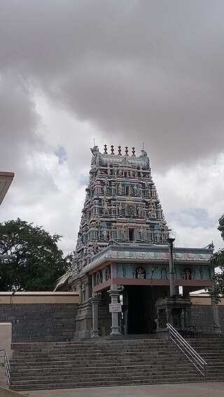
Avinashi is a municipality in the Tiruppur district in the Indian state of Tamil Nadu. Avinashi is one among the nine taluks of the district. It is one of the most popular pilgrim destinations in the Western Tamil Nadu region. It is located off of National Highway NH544, which bypasses the town. The history of the town is centered around the Avinasilingeswarar temple. The town was previously a part of the Coimbatore district until Tirupur was carved out as a separate district from the erstwhile districts of Coimbatore and Erode. It is a stopping place for vehicles travelling from the western part of Tamil Nadu to Chennai and Cochin.
Tiruppur District is one of the 38 districts of the Indian state of Tamil Nadu, formed in 22 February 2009. Dharapuram was the largest taluk by area in the district. The district is well-developed and industrialized. The Tiruppur banian industry, the cotton market, Kangeyam bull and Uthukkuli butter, among other things, provide for a vibrant economy. The city of Tiruppur is the administrative headquarters for the district. As of 2011, the district had a population of 2,479,052 with a sex-ratio of 989 females for every 1,000 males.
Chengapalli is a biggest landmark located in between Salem to Coimbatore Highway Tirupur district, Tamil Nadu, India. It has the status of a panchayat town in Tamil Nadu. It is famous for textiles. Almost 5000 peoples coming from other areas for their employments. It is having four way and six way roads.
Appiyapalayam, is a small village under the Ettiverampalayam panchayat, located 3 km from Perumanallur and 17 km from Tiruppur.
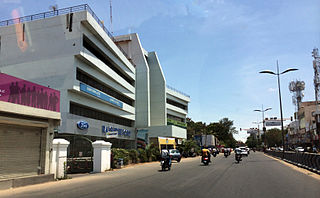
Avinashi Road, is an arterial road in Coimbatore, India. Running from east to west, the road starts at Uppilipalayam flyover and ends at Neelambur by-pass junction where it joins NH 544, Beyond Neelambur Junction, the road branches into two, with one traversing southwards to Madukarai to form the Coimbatore bypass while the other continues westwards to Avinashi and beyond to form the National Highway 544. This road connects Coimbatore to its airport and the east and north-east suburbs. The road was an indicator of development as the city of Coimbatore grew up mostly along its eastern and western sides.
Olalakovil is a panchayat village in the Gobichettipalayam taluk, in Erode District of Tamil Nadu state, India. It is about 33 km from Gobichettipalayam and 70 km from the district headquarters, Erode. Olalakovil is located on the road connecting Gobichettipalayam with Avinashi. Olalakovil has a population of about 8,805.

Tiruppur or Tirupur ( ), is a city in the Indian state of Tamil Nadu. It is located on the banks of the Noyyal river and is the fourth largest urban agglomeration in Tamil Nadu. It is the administrative capital of Tiruppur district and is administered by the Tiruppur Municipal Corporation which was established in 2008.
Kamanaickenpalayam is a town panchayat in the Tiruppur District in the southern Indian state of Tamil Nadu. There are a total of 15 wards in the Panchayat.

