Pesochny, Saint Petersburg

Last updated

Coordinates: 60°07′N30°09′E / 60.12°N 30.15°E / 60.12; 30.15

Geographic coordinate system Coordinate system

A geographic coordinate system is a coordinate system that enables every location on Earth to be specified by a set of numbers, letters or symbols. The coordinates are often chosen such that one of the numbers represents a vertical position and two or three of the numbers represent a horizontal position; alternatively, a geographic position may be expressed in a combined three-dimensional Cartesian vector. A common choice of coordinates is latitude, longitude and elevation. To specify a location on a plane requires a map projection.

Pesochny on the 2006 map of St. Petersburg Spb kur pesochny.svg
Pesochny on the 2006 map of St. Petersburg

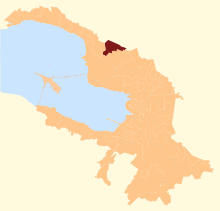
Pesochny (Russian : Песо́чный) is a municipal settlement in Kurortny District of the federal city of St. Petersburg, Russia, located on the Karelian Isthmus, on the northern shore of the Gulf of Finland. Population: 8,130(2010 Census); [1] 6,487(2002 Census); [2] 7,761(1989 Census). [3]

Russian language East Slavic language

Russian is an East Slavic language, which is official in the Russian Federation, Belarus, Kazakhstan and Kyrgyzstan, as well as being widely used throughout Eastern Europe, the Baltic states, the Caucasus and Central Asia. It was the de facto language of the Soviet Union until its dissolution on 25 December 1991. Although nearly three decades have passed since the breakup of the Soviet Union, Russian is used in official capacity or in public life in all the post-Soviet nation-states, as well as in Israel and Mongolia.

Administrative divisions of Saint Petersburg

The federal city of Saint Petersburg, Russia, is divided into eighteen districts, which are in turn subdivided into municipal okrugs, municipal towns, and municipal settlements.

Kurortny District District in federal city of St. Petersburg, Russia

Kurortny District is a district of the federal city of St. Petersburg, Russia, located on the Karelian Isthmus along the northern shore of the Gulf of Finland. As of the 2010 Census, its population: was 70,589; up from 67,511 recorded in the 2002 Census.

Until 1925, it was called Grafskaya koloniya (Графская колония, lit. Colony of the earl), or Grafskoye (Графское) for short. Its Finnish name "Raavski" is derived from that name.

Finnish language language arising and mostly spoken in Finland

Finnish is a Finnic language spoken by the majority of the population in Finland and by ethnic Finns outside Finland. Finnish is one of the two official languages of Finland ; Finnish is also an official minority language in Sweden. In Sweden, both Standard Finnish and Meänkieli, a Finnish dialect, are spoken. The Kven language, a dialect of Finnish, is spoken in Northern Norway by a minority group of Finnish descent.

Related Research Articles

Tavda Town in Sverdlovsk Oblast, Russia

Tavda is a town in Sverdlovsk Oblast, Russia, located on the Tavda River and functioning as a river port. Population: 35,421 (2010 Census); 40,686 (2002 Census); 45,735 (1989 Census).

Khomutovka, Kursk Oblast human settlement in Khomutovsky District, Kursk Oblast, Russia

Khomutovka is an urban locality and the administrative center of Khomutovsky District of Kursk Oblast, Russia. Population: 4,230 (2010 Census); 5,050 (2002 Census); 5,578 (1989 Census). Telephone code: +7 47137; postal code: 307540.

Smolyaninovo is an urban locality and the administrative center of Shkotovsky District of Primorsky Krai, Russia, located 45 kilometers (28 mi) from Vladivostok; 73 kilometers (45 mi) by road. Population: 6,715 (2010 Census); 6,448 (2002 Census); 18,831 (1989 Census).

Kirovsky is an urban locality and the administrative center of Kirovsky District of Primorsky Krai, Russia, located 27 kilometers (17 mi) east of the China–Russia border. Population: 9,057 (2010 Census); 9,698 (2002 Census); 10,662 (1989 Census).

Oktyabrsky, Oktyabrsky District, Perm Krai Work settlement in Perm Krai, Russia

Oktyabrsky is an urban locality and the administrative center of Oktyabrsky District of Perm Krai, Russia. Population: 9,845 (2010 Census); 10,039 (2002 Census); 8,961 (1989 Census).

Beryozovka, Beryozovsky District, Krasnoyarsk Krai Urban-type settlement in Krasnoyarsk Krai, Russia

Beryozovka is an urban locality in Beryozovsky District of Krasnoyarsk Krai, Russia. Population: 20,887 (2010 Census); 21,346 (2002 Census); 20,766 (1989 Census).

Bolshaya Murta Urban-type settlement in Krasnoyarsk Krai, Russia

Bolshaya Murta is an urban locality in Bolshemurtinsky District of Krasnoyarsk Krai, Russia. Population: 7,905 (2010 Census); 8,435 (2002 Census); 8,901 (1989 Census).

Koshurnikovo Urban-type settlement in Krasnoyarsk Krai, Russia

Koshurnikovo is an urban locality in Kuraginsky District of Krasnoyarsk Krai, Russia. Population: 3,492 (2010 Census); 3,802 (2002 Census); 5,163 (1989 Census).

Krasnokamensk, Krasnoyarsk Krai Urban-type settlement in Krasnoyarsk Krai, Russia

Krasnokamensk is an urban locality in Kuraginsky District of Krasnoyarsk Krai, Russia. Population: 4,667 (2010 Census); 4,848 (2002 Census); 5,325 (1989 Census).

Beloomut Urban-type settlement in Moscow Oblast, Russia

Beloomut is an urban locality in Lukhovitsky District of Moscow Oblast, Russia. The population is 6,558 (2010 Census); 7,029 (2002 Census); 8,305 (1989 Census).

Bolshiye Dvory Urban-type settlement in Moscow Oblast, Russia

Bolshiye Dvory is an urban locality in Pavlovo-Posadsky District of Moscow Oblast, Russia. Population: 4,952 (2010 Census); 4,841 (2002 Census); 5,283 (1989 Census).

Cherusti Urban-type settlement in Moscow Oblast, Russia

Cherusti is an urban locality in Shatursky District of Moscow Oblast, Russia. Population: 2,862 (2010 Census); 2,891 (2002 Census); 3,779 (1989 Census).

Stolbovaya Urban-type settlement in Moscow Oblast, Russia

Stolbovaya is an urban locality in Chekhovsky District of Moscow Oblast, Russia. Population: 5,082 (2010 Census); 5,185 (2002 Census); 5,566 (1989 Census).

Zhilyovo Urban-type settlement in Moscow Oblast, Russia

Zhilyovo is an urban locality in Stupinsky District of Moscow Oblast, Russia. Population: 2,472 (2010 Census); 2,468 (2002 Census); 2,733 (1989 Census).

Misheronsky Urban-type settlement in Moscow Oblast, Russia

Misheronsky is an urban locality in Shatursky District of Moscow Oblast, Russia. Population: 3,857 (2010 Census); 3,821 (2002 Census); 4,249 (1989 Census).

Mikhnevo Urban-type settlement in Moscow Oblast, Russia

Mikhnevo is an urban locality in Stupinsky District of Moscow Oblast, Russia. Population: 11,267 (2010 Census); 10,831 (2002 Census); 9,192 (1989 Census).

Malino, Moscow Oblast Urban-type settlement in Moscow Oblast, Russia

Malino is an urban locality in Stupinsky District of Moscow Oblast, Russia. Population: 4,108 (2010 Census); 4,363 (2002 Census); 3,172 (1989 Census). It is the site of Malino Airfield.

Peski, Kolomensky District, Moscow Oblast Urban-type settlement in Moscow Oblast, Russia

Peski is an urban locality in Kolomensky District of Moscow Oblast, Russia. Population: 3,845 (2010 Census); 3,736 (2002 Census); 4,074 (1989 Census).

Snegiri Urban-type settlement in Moscow Oblast, Russia

Snegiri is an urban locality in Istrinsky District of Moscow Oblast, Russia. Population: 3,177 (2010 Census); 3,494 (2002 Census); 4,252 (1989 Census).

Zaterechny (urban-type settlement) Urban-type settlement in Stavropol Krai, Russia

Zaterechny is an urban locality in Neftekumsky District of Stavropol Krai, Russia. Population: 7,696 (2010 Census); 7,697 (2002 Census); 6,272 (1989 Census).

References

  1. Russian Federal State Statistics Service (2011). "Всероссийская перепись населения 2010 года. Том 1" [2010 All-Russian Population Census, vol. 1]. Всероссийская перепись населения 2010 года (2010 All-Russia Population Census) (in Russian). Federal State Statistics Service . Retrieved June 29, 2012.
  2. Russian Federal State Statistics Service (May 21, 2004). "Численность населения России, субъектов Российской Федерации в составе федеральных округов, районов, городских поселений, сельских населённых пунктов – районных центров и сельских населённых пунктов с населением 3 тысячи и более человек" [Population of Russia, Its Federal Districts, Federal Subjects, Districts, Urban Localities, Rural Localities—Administrative Centers, and Rural Localities with Population of Over 3,000](XLS). Всероссийская перепись населения 2002 года [All-Russia Population Census of 2002] (in Russian). Retrieved August 9, 2014.
  3. Demoscope Weekly (1989). "Всесоюзная перепись населения 1989 г. Численность наличного населения союзных и автономных республик, автономных областей и округов, краёв, областей, районов, городских поселений и сёл-райцентров" [All Union Population Census of 1989: Present Population of Union and Autonomous Republics, Autonomous Oblasts and Okrugs, Krais, Oblasts, Districts, Urban Settlements, and Villages Serving as District Administrative Centers]. Всесоюзная перепись населения 1989 года [All-Union Population Census of 1989] (in Russian). Институт демографии Национального исследовательского университета: Высшая школа экономики [Institute of Demography at the National Research University: Higher School of Economics]. Retrieved August 9, 2014.