
The Ross Sea is a deep bay of the Southern Ocean in Antarctica, between Victoria Land and Marie Byrd Land and within the Ross Embayment, and is the southernmost sea on Earth. It derives its name from the British explorer James Clark Ross who visited this area in 1841. To the west of the sea lies Ross Island and Victoria Land, to the east Roosevelt Island and Edward VII Peninsula in Marie Byrd Land, while the southernmost part is covered by the Ross Ice Shelf, and is about 200 miles (320 km) from the South Pole. Its boundaries and area have been defined by the New Zealand National Institute of Water and Atmospheric Research as having an area of 637,000 square kilometres (246,000 sq mi).
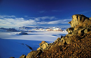
The Transantarctic Mountains comprise a mountain range of uplifted rock in Antarctica which extends, with some interruptions, across the continent from Cape Adare in northern Victoria Land to Coats Land. These mountains divide East Antarctica and West Antarctica. They include a number of separately named mountain groups, which are often again subdivided into smaller ranges.

Skelton Glacier is a large glacier flowing from the polar plateau into the Ross Ice Shelf at Skelton Inlet on the Hillary Coast, south of Victoria Land, Antarctica.

The Axel Heiberg Glacier in Antarctica is a valley glacier, 30 nmi (35 mi) long, descending from the high elevations of the Antarctic Plateau into the Ross Ice Shelf between the Herbert Range and Mount Don Pedro Christophersen in the Queen Maud Mountains.

The geology of Antarctica covers the geological development of the continent through the Archean, Proterozoic and Phanerozoic eons.

The Hanson Formation is a geologic formation on Mount Kirkpatrick and north Victoria Land, Antarctica. It is one of the two major dinosaur-bearing rock groups found on Antarctica to date; the other is the Snow Hill Island Formation and related formations from the Late Cretaceous of the Antarctic Peninsula. The formation has yielded some Mesozoic specimens, but most of it is as yet unexcavated. Part of the Victoria Group of the Transantarctic Mountains, it lies below the Prebble Formation and above the Falla Formation. The formation includes material from volcanic activity linked to the Karoo-Ferar eruptions of the Lower Jurassic. The climate of the zone was similar to that of modern southern Chile, humid, with a temperature interval of 17–18 degrees. The Hanson Formation is correlated with the Section Peak Formation of the Eisenhower Range and Deep Freeze Range, as well as volcanic deposits on the Convoy Range and Ricker Hills of southern Victoria Land.
The Fremouw Formation is a Triassic-age rock formation in the Transantarctic Mountains of Antarctica. It contains the oldest known fossils of tetrapods from Antarctica, including synapsids, reptiles and amphibians. Fossilized trees have also been found. The formation's beds were deposited along the banks of rivers and on floodplains. During the Triassic, the area would have been a riparian forest at 70–75°S latitude.
The Allan Hills are a group of hills at the end of the Transantarctic Mountains System, located in Oates Land and Victoria Land regions of Antarctica.

Timothy Raymond Naish is a New Zealand glaciologist and climate scientist who has been a researcher and lecturer at Victoria University of Wellington and the Director of the Antarctic Research Centre, and in 2020 became a programme leader at the Antarctic Science Platform. Naish has researched and written about the possible effect of melting ice sheets in Antarctica on global sea levels due to high CO2 emissions causing warming in the Southern Ocean. He was instrumental in establishing and leading the Antarctica Drilling Project (ANDRILL), and a Lead Author on the Intergovernmental Panel on Climate Change (IPCC) 5th Assessment Report (2014).
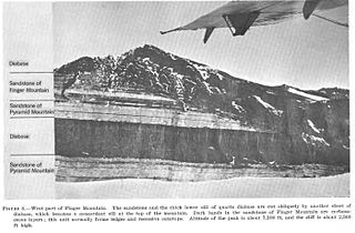
The Beacon Supergroup is a geological formation exposed in Antarctica and deposited from the Devonian to the Triassic. The unit was originally described as either a formation or sandstone, and upgraded to group and supergroup as time passed. It contains a sandy member known as the Beacon Heights Orthoquartzite.
Mullins Valley is a four mile long valley located at 5,400 ft elevation in the McMurdo Dry Valleys. It is one of the few dry valleys in the world to contain rock glaciers. US Antarctic Program (USAP) research has dated the subsurface ice in Mullins Valley at 4 million years old making it among the oldest ice on earth. United States Antarctic Program (USAP) research has also shown the rock glaciers in the valley to be analogous to the Arsia Mons region on Mars. Named for Jerry L. Mullins, Physical Scientist, Director, Polar Programs, Antarctic and Arctic Program for United States Geological Survey (USGS), National Science Foundation Antarctic geophysical research, and U.S Scientific Committee (SCAR) delegate to SCAR SCAGI committee. Appointed by the National Academy of Sciences, Polar Research Board. His was responsible for Antarctic field research in the Transantarctic Mountains, McMurdo Dry Valleys, Shackleton Mountains, Beardmore Mountains, Antarctic Peninsula, Mount Siple, Amundsen-Scott South Pole station and at deep field research locations in West Antarctica. His program conducted research in the disciplines of global positioning systems, geodesy, crustal motion, glacial geophysics, airborne geospatial systems, airborne geophysics, seismology, light radar (lidar), topographic mapping and he managed the USGS South Pole winter-over program from 1989 to 1994. He was appointed by the National Academy of Sciences, Polar Research Board as a US delegate to the Scientific Committee on Antarctic Research Geosciences Standing Scientific Group from 1995–July 2012 and was appointed as a member of the Advisory Committee on Antarctic Names in 1994. Mullins Valley appears in the Antarctic research literature, on the maps from the British expedition of Captain Scott and in aerial photographs from the United States expedition Operation Highjump by Admiral Byrd. Mullins Valley, Mullins Lake, Mullins Glacier, and Mullins Geodetic Station, Antarctica are named for United States polar explorer and researcher Jerry L. Mullins.
The New Zealand Antarctic Research Programme (NZARP) was a research programme that operated a permanent research facility in Antarctica from 1959 to 1996. It was created by the Geophysics Division of New Zealand's Department of Scientific and Industrial Research (DSIR), originally based in Wellington. The programme promoted research in geochemistry, zoology, geology, botany, meteorology, and limnology.
The Antarctic Research Centre (ARC) is part of the School of Geography, Environment and Earth Sciences at Victoria University of Wellington. Its mission is to research "Antarctic climate history and processes, and their influence on the global climate system. The current director of the Antarctic Research Centre is Associate Professor Robert McKay.

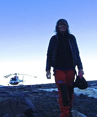
Nancy Bertler is an Antarctic researcher, who has led major initiatives to investigate climate history using Antarctic ice cores, and best known for her leadership of the Roosevelt Island Climate Evolution Programme (RICE). She is a full professor at the Antarctic Research Centre at Victoria University of Wellington in New Zealand.

Rosemary Anne Askin, also known as Rosemary Askin Cully, is a New Zealand geologist specialising in Antarctic palynology. She was a trailblazer for women in Antarctic science, becoming the first New Zealand woman to undertake her own research programme in Antarctica in 1970.
Laura Crispini is an Italian geologist and an Antarctic researcher. Her areas of expertise are for the Tectonics, Geodynamics and Geological Mapping including the Geology of Antarctica. She has been nominated among 150 International representative of female Antarctic researchers for the SCAR "Celebration of Women in Antarctic Research" wikibomb event. At present she is Professor at the University of Genoa at the Department for Earth Sciences, Envinronment and life (DISTAV).
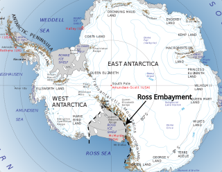
The Ross Embayment is a large region of Antarctica, comprising the Ross Ice Shelf and the Ross Sea, that lies between East and West Antarctica.
Te Anga is a rural community in the Waitomo District and Waikato region of New Zealand's North Island.

The Mawson Formation is a geological formation in Antarctica, dating to roughly between 182 and 177 million years ago and covering the Toarcian stages of the Jurassic Period in the Mesozoic Era. Vertebrate remains are known from the formation. The Mawson Formation is the South Victoria Land equivalent of the Karoo Large Igneous Province in South Africa, as well the Lonco Trapial Formation and the Cañadón Asfalto Formation of Argentina.

Robert Murray McKay is a paleoceanographer who specialises in sedimentology, stratigraphy and palaeoclimatology, specifically gathering geological evidence to study how marine-based portions of the Antarctic ice sheet behave in response to abrupt climate and oceanic change. He has been involved in examination of marine sedimentary records and glacial deposits to show melting and cooling in Antarctica over the past 65 million years and how this has influenced global sea levels and climate. This has helped climate change scientists overcome uncertainty about how the ice sheets will respond to global warming and how this can be managed effectively in the 21st century. He has participated in international projects including ANDRILL and the International Ocean Discovery Program (IODP), led major New Zealand government-funded research teams and has received several awards in recognition of his work. Since 2023 McKay has been a full professor at Victoria University of Wellington and from 2019, director of the Antarctic Research Centre.
