Related Research Articles


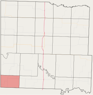
Osage County is a county located in the U.S. state of Kansas. Its county seat is Lyndon, and its most populous city is Osage City. As of the 2020 census, the county population was 15,766. The county was originally organized in 1855 as Weller County, then renamed in 1859 after the Osage tribe.

Franklin County is a county located in the eastern portion of the U.S. state of Kansas. Its county seat and most populous city is Ottawa. As of the 2020 census, the county population was 25,996. The county was named for Benjamin Franklin, a founding father of the United States. Formerly it was considered part of the Kansas City metropolitan area, but was removed in 2013.

Chetopa is a city in Labette County, Kansas, United States. As of the 2020 census, the population of the city was 929. Chetopa was named for Chief Chetopah, an Osage Indian chief. Later, the community name was shortened.

Lyndon is a city in, and the county seat of Osage County, Kansas, United States. As of the 2020 census, the population of the city was 1,037.

Melvern is a city in Osage County, Kansas, United States, along the Marais des Cygnes River. As of the 2020 census, the population of the city was 356.

Olivet is a city in Osage County, Kansas, United States. As of the 2020 census, the population of the city was 73. It is located near the south side of Melvern Lake.

Osage City is a city in Osage County, Kansas, United States. As of the 2020 census, the population of the city was 2,861.

Neodesha is a city in Wilson County, Kansas, United States. As of the 2020 census, the population of the city was 2,275. The name is derived from the Osage Indian word, Ni-o-sho-de, and is translated as The-Water-Is-Smoky-With-Mud.
East-Central Kansas is a region of Kansas. It is located between the Kansas City metropolitan area and Southeast Kansas, and on the border with Missouri. The region extends westward towards the Flint Hills to Lyon County. East-Central Kansas geographically features rolling hills and deep forested river valleys. The main crop of this predominantly agricultural region is corn. The area is more forested and more moist compared to the rest of the state. East-Central Kansas is rich with state history, as many locations of this region saw battles in Bleeding Kansas, and the infamous abolitionist John Brown and his men battled in Osawatomie. Much of the area is powered by Wolf Creek Nuclear Generating Station which is located near Burlington. The most populous cities of the region include Emporia, Ottawa, Paola, Osawatomie, Garnett, Osage City, Burlington, and Louisburg.
Cofachique is a ghost town situated along the Neosho River near the present-day city of Iola in Allen County, Kansas, United States. Being the first town established in Allen County in 1855, it was the original county seat. However, within five years the greater part of the town was moved to the new town of Iola, while the old site of Cofachique became farm land. The town was named in honor of an Osage chief known as Cofachique, who is said to have been particularly helpful to early settlers, bringing aid to the distressed and homeless. The name "Cofachique" appears to have origins with the Cofachiqui tribe in South Carolina, who were Siouan speakers, and the Osage who settled this area were closely affiliated with the Siouan.

Marion Township is a township in Douglas County, Kansas, USA. As of the 2000 census, its population was 836. It was named after the former town of Marion which in turn was named after Francis Marion.
Howard Township is one of twenty-four townships in Bates County, Missouri, and is part of the Kansas City metropolitan area within the USA. As of the 2000 census, its population was 552.

Prairie Township is one of twenty-four townships in Bates County, Missouri, and is part of the Kansas City metropolitan area within the USA. As of the 2000 census, its population was 153.
Barclay is an unincorporated community in Osage County, Kansas, United States.
Chetopa Township is a township in Wilson County, Kansas, in the United States.
Neodesha Township is a township in Wilson County, Kansas, United States.
Kennedy is an unincorporated community in Cherry County, Nebraska, United States.
Ottumwa is an unincorporated community in Coffey County, Kansas, United States.
References
- ↑ "Peterton, Kansas", Geographic Names Information System , United States Geological Survey, United States Department of the Interior
- ↑ "Kansas Post Offices, 1828-1961". Kansas Historical Society. Archived from the original on October 9, 2013. Retrieved June 22, 2014.
