Petrel, North Dakota

Last updated

Petrel, North Dakota
Petrel, North Dakota.jpg
Sign along the railroad tracks in Petrel, North Dakota
USA North Dakota location map.svg
Red pog.svg
Petrel
Location in North Dakota
Usa edcp location map.svg
Red pog.svg
Petrel
Location in the United States
Coordinates: 45°56′54″N102°16′38″W / 45.94833°N 102.27722°W / 45.94833; -102.27722
Country United States
State North Dakota
County Adams
Township Gilstrap
First Settled1908
Elevation
[1]
2,566 ft (782 m)
Time zone UTC-7 (Mountain (MST))
  Summer (DST) UTC-6 (MDT)
ZIP Code
57638
Area code 701
FIPS code38-62020
GNIS feature ID1033784 [1]

Petrel is a ghost town in Adams County, North Dakota, United States. It is located just across the border with South Dakota, between Lemmon, South Dakota, in Perkins County and Haynes. Petrel is a former railroad townsite and siding on the Milwaukee Road. The town was named for the long-winged pigeons seen in the area. [2]

Contents

History

The only railroad crossing in town is a reminder that the tracks are still in use today, even if the town is not. Railroad crossing in Petrel, North Dakota.jpg
The only railroad crossing in town is a reminder that the tracks are still in use today, even if the town is not.

Petrel was established as a townsite along the Chicago, Milwaukee, St. Paul and Pacific Railroad in Gilstrap Township. A post office was established in the town on October 29, 1908 when the post office for the neighboring area of Thebes was moved to the new townsite and assumed the new name. The Petrel post office closed September 30, 1939, and mail service was transferred to Lemmon, South Dakota. [2] As a result the town and the surrounding area share the Lemmon ZIP Code of 57638, even though they are in North Dakota. Little remains of the physical town today, other than a few deteriorating building foundations and other equipment. [3]

BNSF Railway operates the railroad today. Petrel is located at mile marker 909.7. [4]

The city of Rhame in neighboring Bowman County was originally named Petrel when it was founded in 1908, but the name was soon changed to avoid confusion. [2]

Geography

Petrel is located roughly 1 mile (1.6 km) north of the North Dakota-South Dakota border. It is 6 miles (9.7 km) from Lemmon and 21 miles (34 km) from Hettinger, the county seat of Adams County, North Dakota.

Abandoned equipment lies rusting in much of the townsite. Abandoned equipment in Petrel, North Dakota.jpg
Abandoned equipment lies rusting in much of the townsite.

Demographics

Petrel had approximately 100 people living there in the mid to late 1910s. [5] A population of roughly 65 people was recorded in 1960. [2] Today, it is a ghost town, with much of the population spread throughout the countryside. Today, the United States Census Bureau does not track specific population numbers for the community, but the surrounding township had a population of 28 as of the 2000 Census. [6]

Notable people

Related Research Articles

<span class="mw-page-title-main">Adams County, North Dakota</span> County in North Dakota, United States

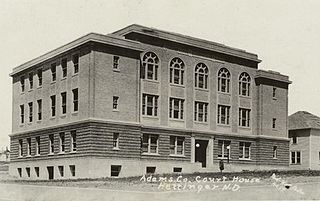
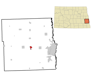
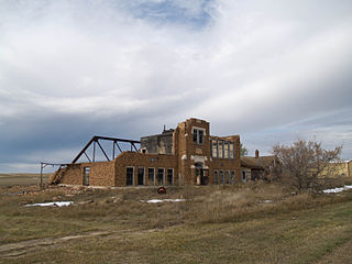
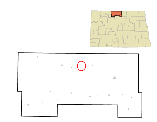
Adams County is a county in the U.S. state of North Dakota. As of the 2020 census, the population was 2,200. The county seat is Hettinger. The county was created on April 17, 1907, and organized one week later. It was named for John Quincy Adams (1848–1919), a railroad official for the Milwaukee Road Railroad and distant relative of sixth U.S. President John Quincy Adams (1767–1848).

<span class="mw-page-title-main">Dilworth, Minnesota</span> City in Minnesota, United States

Dilworth is a city in Clay County, Minnesota, United States. The population was 4,612 at the time of the 2020 census. Dilworth is one of the core cities of the Fargo–Moorhead metro area; it is on the eastern border of Moorhead. Dilworth is home to the historic Star Lite Motel and the Dilworth Rail Yard, one of the BNSF Railway's largest and busiest facilities in Minnesota.

<span class="mw-page-title-main">Rhame, North Dakota</span> City in North Dakota, United States

Rhame is a city in Bowman County, North Dakota, United States. The population was 158 at the 2020 census. Rhame was founded in 1908.

<span class="mw-page-title-main">Casselton, North Dakota</span> City in North Dakota, United States

Casselton is a city in Cass County, North Dakota, United States. The population was 2,479 at the 2020 census. making it the 20th largest city in North Dakota. Casselton was founded in 1876. The city is named in honor of George Washington Cass, a president of the Northern Pacific Railway, which established a station there in 1876 to develop a town for homesteaders. Casselton is the hometown of five North Dakota governors.

<span class="mw-page-title-main">Christine, North Dakota</span> City in North Dakota, United States

Christine is a city in Richland County, North Dakota, United States. The population was 151 at the 2020 census. Christine was founded in 1883. It is part of the Wahpeton, ND–MN Micropolitan Statistical Area.

<span class="mw-page-title-main">Buxton, North Dakota</span> City in North Dakota, United States

Buxton is a city in Traill County, North Dakota, United States. The population was 348 at the 2020 census. Buxton was founded in 1880.

Ada is a township in Dickey County, North Dakota, United States. Its population during the 2020 Census was 29, down from 60 in 2000. Its population in 1900 was 232.

Advance Township is a township in Pembina County, North Dakota, United States. At the time of the 2000 Census, its population was 143, with an estimated 122 people as of 2009.

<span class="mw-page-title-main">Temvik, North Dakota</span> Ghost town in North Dakota, United States

Temvik is a ghost town in Emmons County, North Dakota, United States. It is situated between Linton and Hazelton. The town had a school and several grain elevators early in the twentieth century; all that remains today is a farm.

<span class="mw-page-title-main">Omemee, North Dakota</span> Place in North Dakota, United States

Omemee is a ghost town in Bottineau County in the U.S. state of North Dakota. It was a railroad hub in the early 1910s, located at the junction of two major railroads, the Soo Line Railroad and the Great Northern Railway. Incorporated as a city in 1902, Omemee has been abandoned since 2003.

<span class="mw-page-title-main">Wheelock, North Dakota</span> Ghost town in North Dakota, United States

Wheelock is a ghost town in Wheelock Township, Williams County, in the northwestern part of the U.S. state of North Dakota. In 1938, the Federal Writers' Project found a population of 115 in Wheelock. In the 1990 census, the population was 23. All census population figures after 1990 are estimates. The town was disincorporated in 1994.

Macdona is an unincorporated community and census-designated place in Bexar County, Texas, United States. As of the 2010 census, it had a population of 559. Macdona lies along the Union Pacific rail line near Loop 1604 in southwest Bexar County. It is part of the San Antonio Metropolitan Statistical Area.

<span class="mw-page-title-main">Verendrye, North Dakota</span> Ghost town in North Dakota, U.S.

Verendrye was a historic unincorporated community in McHenry County, North Dakota, United States, located approximately eight miles (13 km) northwest of Karlsruhe and 13 miles (21 km) northeast of Velva within Falsen Township. Although classified by the USGS as a populated place, it is considered a ghost town.

<span class="mw-page-title-main">North Lemmon, North Dakota</span> Unincorporated community in North Dakota, United States

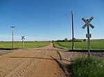
North Lemmon is an unincorporated community in Adams County, North Dakota, United States. A local landowner, George E. Lemmon, is the town's namesake.

Gilstrap Township is a township in Adams County, North Dakota, United States. As of the 2010 census, its population was 20.

<span class="mw-page-title-main">Temple, North Dakota</span>

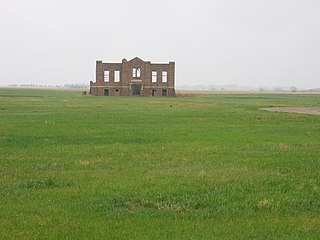
Temple is ghost town located in Williams County, North Dakota, United States. There are some remaining structures which include: a small garage, a couple small outbuildings and a couple caved-in houses. In 2003, one of the last two business buildings was either torn down or burned. The school was moved in 2010 and reportedly used as an addition to a house. The last business building collapsed in 2010, and was disposed of by 2012. One of the few remaining abandoned houses was destroyed in 2015. Also in 2015, the church was burned and razed, the reason is said to be because "it had deteriorated to the point that it became dangerous." There is now an occupied camper on the same spot the school was located.

<span class="mw-page-title-main">Roth, North Dakota</span> Unincorporated community in North Dakota, United States

Roth is an unincorporated rural hamlet in Bottineau County in the U.S. state of North Dakota. It is located roughly 6 miles (9.7 km) to the west of Souris. There are less than half a dozen houses at Roth along a loop road, and no businesses or services.

<span class="mw-page-title-main">Carbury, North Dakota</span> Unincorporated community in North Dakota, United States

Carbury is an unincorporated community in Bottineau County in the U.S. state of North Dakota. It is located along North Dakota Highway 14 in the eastern part of the county, east of Souris. The town is virtually abandoned, and the 2000 Census did not record a population. The post office closed in 1984, and it is now part of zip code 58783 covered by the post office in Souris.

<span class="mw-page-title-main">Dresbach, Minnesota</span> Unincorporated community in Minnesota, United States

Dresbach is an unincorporated community in Dresbach Township, Winona County, Minnesota, United States.

<span class="mw-page-title-main">Russell, North Dakota</span> Unincorporated community in North Dakota, United States

Russell is an unincorporated hamlet in Bottineau County in the U.S. state of North Dakota. There are no businesses or services there, only about half a dozen homes scattered along narrow, intersecting dirt roads.

References

  1. 1 2 U.S. Geological Survey Geographic Names Information System: Petrel, North Dakota
  2. 1 2 3 4 Wick, Douglas A. (1988). North Dakota Place Names. Hedemarken Collectibles. p. 153. ISBN   0-9620968-0-6.
  3. Photos of Petrel, North Dakota on Flickr
  4. "Burlington Northern Santa Fe Railway, Twin Cities Division" (PDF). BNSF Railway. 2006. Archived from the original (PDF) on May 17, 2008. Retrieved July 19, 2008.
  5. Clason's Guide to North Dakota. Clason's Pocket Guide Maps. Denver, Colorado: The Clason Map Co. 1917. p. 27.
  6. U.S. Census Bureau. Census 2000. "Census Demographic Profiles, Gilstrap Township" (PDF). CenStats Databases. Retrieved January 31, 2009.{{cite web}}: CS1 maint: numeric names: authors list (link)[ dead link ]
  7. Dakota Lawmakers Archived 2010-05-27 at the Wayback Machine , North Dakota Legislative Council
  8. Stinger's Post Office is recorded as being in Petrel by the North Dakota Legislative Assembly. However, Stinger resided in nearby Spring Butte Township.
  9. Dakota Lawmakers Archived 2009-04-16 at the Wayback Machine , North Dakota Legislative Council