Kanchanaburi is the largest of the western provinces (changwat) of Thailand. The neighboring provinces are Tak, Uthai Thani, Suphan Buri, Nakhon Pathom, and Ratchaburi. In the west it borders Kayin State, Mon State, and the Tanintharyi Region of Myanmar.

Kampot is a province in southwestern Cambodia. It borders the provinces of Koh Kong and Kampong Speu to the north, Takéo to the east, Kep and the country of Vietnam to the south, and Sihanoukville to the west. To its south it has a coastline of around 45 km on the Gulf of Thailand. It is rich in low arable lands and has abundant natural resources. Its capital is the city of Kampot.

Patuxai is a war monument in Downtown Vientiane, Laos, built between 1957 and 1968. The Patuxai was dedicated to those who fought in the struggle for independence from France. In romanizing the name from the Laotian language, it is variously transliterated as Patuxai, Patuxay, Patousai and Patusai. It is also called Patuxai Arch or the Arc de Triomphe of Vientiane as it resembles the Arc de Triomphe in Paris. However, it is typically Laotian in design, decorated with mythological creatures such as the kinnari .

Kbal Spean is an Angkorian-era archaeological site on the southwest slopes of the Kulen Hills to the northeast of Angkor in Banteay Srei District, Siem Reap Province, Cambodia. It is situated along a 150m stretch of the Stung Kbal Spean River, 25 kilometres (16 mi) from the main Angkor group of monuments, which lie downstream.

The Silver Pagoda is located on the south side of the Royal Palace in Chey Chumneas, Phnom Penh. The official name is Wat Ubaosoth Ratanaram, also known as Wat Preah Keo Morakot which is commonly shortened to Wat Preah Keo in Khmer.

Auguste Jean-Marie Pavie was a French colonial civil servant, explorer and diplomat who was instrumental in establishing French control over Laos in the last two decades of the 19th century. After a long career in Cambodia and Cochinchina, Pavie became the first French vice-consul in Luang Prabang in 1886, eventually becoming the first Governor-General and plenipotentiary minister of the newly formed French colony of Laos.

Preah Sihanouk, also Sihanoukville, is a province (khaet) in southwest Cambodia on the Gulf of Thailand. The provincial capital, also called Sihanoukville, is a deep water port city and a steadily growing and diversifying urban center on an elevated peninsula.
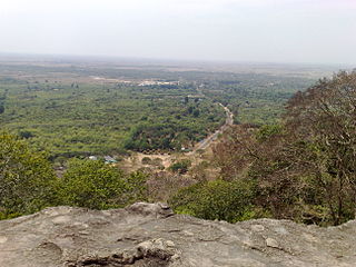
Preah Monivong Bokor National Park is a national park in southern Cambodia's Kampot Province that was established in 1993 and covers 1,544.58 km2 (596.37 sq mi). In 2003, it was designated as an ASEAN Heritage Park. It is located in the Dâmrei Mountains, forming the southeastern parts of the Cardamom Mountains. Most of the park is about 1,000 metres above sea level and the highest peak is Phnom Bokor at 1,081 metres, also referred to as Bokor Mountain.

Khoun Kong Leng Lake, also Kong Leng Lake, is a lake of Khammouane Province, Laos, located roughly 30 miles north of Thakhek in the Phu Hin Pun foothills. The lake is roughly 21 metres (70 ft) deep in the centre and is a bright emerald colour. Lonely Planet describes it as "stunningly beautiful", "luminescent green waters [which] spring from a subterranean river." The underground water flows through limestone, which gives the water its green colour. The lake is revered by the locals who believe it has mystical powers and the ability to ring a gong in the dead of night on full moon. The name of the lake "Kong Leng" means "evening gong", reflecting local belief.
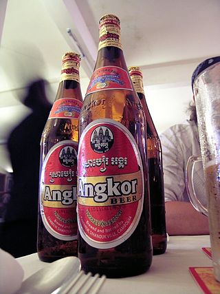
Angkor Beer is a Cambodian lager, named after the iconic Khmer Angkor temples near Siem Reap. It is the most widely consumed beer in Cambodia. Along with Klang Beer, Bayon Beer, Angkor Extra Stout, and Black Panther Premium Stout, it is brewed at the Cambrew Brewery in Sihanoukville. Its official motto is "My Country, My Beer"
Cambrew Ltd (Angkor Brewery) is the largest brewery in Cambodia, situated in Sihanoukville. The brewery produces Angkor Beer (the most widely consumed beer in the country and acknowledged as Cambodia’s national beer), Klang Beer, Bayon Beer, Angkor Extra Stout and Black Panther Premium Stout.

Bokeo is a northern province of Laos. It is the smallest and second least populous province in the country. Bokeo province covers an area of 6,196 square kilometres (2,392 sq mi). Bokeo province borders Luang Namtha province to the northeast, Oudomxai province to the east, Xaignabouli province to the south, and Thailand to the southwest and Burma to the west and northwest. The province has five districts: and the Golden Triangle Special Economic Zone in Ton Pheung district. It is rich in deposits of precious and semiprecious stones. Bokeo's provincial capital is Houayxay on the Mekong River. The province is in the Golden Triangle, at the border of Myanmar and Thailand. There are 34 ethnic groups in the province. Houay Xay is a border town with Thailand and regional economic centre.

Sainyabuli province is a province in northwest Laos. The capital of the province is the town of Saiyabuli. Saiyabuli is the only Lao province that is completely west of the Mekong River.

Luang Prabang is a province in northern Laos. Its capital of the same name, Luang Prabang, was the capital of the Lan Xang Kingdom during the 13th to 16th centuries. It is listed since 1995 by UNESCO as a World Heritage Site for unique architectural, religious and cultural heritage, a blend of the rural and urban developments over several centuries, including the French colonial influences during the 19th and 20th centuries. The province has 12 districts. The Royal Palace, the national museum in the capital city, and the Phou Loei Protected Reserve are important sites. Notable temples in the province are the Wat Xieng Thong, Wat Wisunarat, Wat Sen, Wat Xieng Muan, and Wat Manorom. The Lao New Year is celebrated in April as The Bun Pi Mai.

Champasak is a province in southwestern Laos, near the borders with Thailand and Cambodia. It is one of the three principalities that succeeded the Lao kingdom of Lan Xang. As of the 2015 census, it had a population of 694,023. The capital is Pakse, but the province takes its name from Champasak, the former capital of the Kingdom of Champasak.
Santuk Silk Farm is a silk farm, located about 11 miles (18km) southeast of Kampong Thom City, Cambodia, near the village of Kakaoh. The farm, established by Vietnam War veteran Bud Gibbons in 2006, demonstrates the process of the silk worm, from its earliest stages, from egg to cocoon. The farm employs some 15 girls to weave the raw silk into thread; they make scarves and other items, sold in the shop on site.
Phnom Santuk is a hill and cultural site in the Cambodian province of Kampong Thom. Located in Ko Koh village, Ko Koh commune, Santuk District, it is the most sacred mountain of the province. The summit is accessed by a stone pathway with many statues flanking the way. At the top is a white-walled temple and many shrines and deities, including several reclining Buddhas made out of rock, measuring more than 33 feet (10 m) in length. Monks inhabit the site.
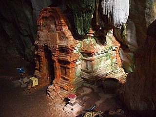
Phnom Chhnork is a Hindu cave temple in Kampot Province, southern Cambodia, located about 5 miles (8.0 km) north-east of Kampot. The temple was built in the 7th century from Funan brick, dedicated to Shiva. It is accessed via stone steps.

The killing caves of Phnom Sampeau are a Khmer Rouge execution site on Phnom Sampeau, a hill 7 mi (11 km) southwest of Battambang in western Cambodia. The Khmer Rouge killed their victims on top of the cave at the rim of a daylight shaft or ceiling hole and then threw the dead body into the cave. Men and women were placed in separate caves and clothes in another. There are a number of caves at Phnom Sampeau that have traditionally served as Buddhist temples. Today there is a large glass memorial in the cave next to the skulls and bones and a golden reclining Buddha, that can be reached via a staircase. A memorial, assembled from cyclone fencing and chicken wire contains human bones at the base of the stairway.
Sai Yok National Park is a national park in Sai Yok district, Kanchanaburi Province, Thailand. The park, home to mountains, waterfalls and caves, is part of the Western Forest Complex protected area.