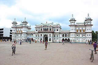
Dhanusha District,, a part of Province No. 2, is one of the seventy-seven districts of Nepal. It is situated in the Outer Terai. The district, with Janakpur as its district headquarter, covers an area of 1,180 km2 (460 sq mi) and has a population (2011) of 754,777.

Ballagoth is a village development committee in Dhanusa District in the Janakpur Zone of south-eastern Nepal. At the time of the 1991 Nepal census it had a population of 3,265 and had 543 houses.

Baniniya is a village development committee in Dhanusa District in the Janakpur Zone of south-eastern Nepal. At the time of the 1991 Nepal census it had a population of 3,255 and had 561 houses.

Basbitti is a village development committee in Dhanusa District in the Janakpur Zone of south-eastern Nepal. At the time of the 1991 Nepal census it had a population of 2,000 and had 351 houses.
Bhutahi Paterwa is a village development committee in Dhanusa District in the Janakpur Zone of south-eastern Nepal. At the time of the 1991 Nepal census it had a population of 3,748 persons living in 739 individual households.

Chakkar is a village development committee in Dhanusa District in the Janakpur Zone of south-eastern Nepal. At the time of the 1991 Nepal census it had a population of 4,419 persons living in 799 individual households.

Devpura Rupetha is a [Janakpur Deputy Metropolitan city](Nepal)|village development committee]] in Dhanusa District in the [[Janakpur Zone]] of south-eastern Nepal. At the time of the [[201 1 Nepal census]] it had a population of 8348 persons living in 1259 individual households.

Dhanushadham is a municipality in Dhanusha District in Province No. 2 of south-eastern Nepal. The municipality was established on 18 May 2014 by merging the existing Govindapur, Umprempur, Yagyabhumi, Dhanushadham village development committees (VDCs). It is a religious place of Hindu worship in Nepal. It is believed that a part of Shiva Dhanusha that was broken by Rama during Sita's swayamvara, is housed. Now there is temple around the remaining of bow and visited by Hindu devotees from all over the world. That's why it is named Dhanushadham.

Jhojhi Kataiya is a village development committee in Dhanusa District in the Janakpur Zone of south-eastern Nepal. At the time of the 1991 Nepal census it had a population of 3,169 persons living in 513 individual households.
Lohana Bahbangama is a village development committee in Dhanusa District in the Janakpur Zone of south-eastern Nepal. At the time of the 1991 Nepal census it had a population of 4,772 persons living in 824 individual households. It is near to Janakpur. This village is surrounded by.

Kurtha is a part of Janakpur sub metropolitan city in Dhanusa District in the Janakpur Zone of south-eastern Nepal. At the time of the 2018 Nepal census it had a population of 7,815 persons living in 1450+ individual households. Ramanand Chowk and piradi chowk are in the east of Kurtha. Mahadaiya is in the west of Kurtha. Bispitti is in the south of Kurtha. Kurtha is most populated of Dhanusha district.
Papikleshwar is a village development committee in Dhanusa District in the Janakpur Zone of south-eastern Nepal. At the time of the 1991 Nepal census it had a population of 4,101 persons living in 691 individual households.

Singyahi Madan was Villages development committee (Nepal) in Dhanusa District in the Janakpur Zone of south-easter,Province-02 Nepal.Now it's comes under kamala municipality. At the time of the 1991 Nepal census it had a population of 7,203 persons living in 1296 individual households. It is an agricultural area.

Mansingpatti is a village development committee in Dhanusa District in the Janakpur Zone of south-eastern Nepal. At the time of the 1991 Nepal census it had a population of 3,293 persons living in 567 individual households.

Paterwa is a village development committee in Dhanusa District in the Janakpur Zone of south-eastern Nepal. At the time of the 1991 Nepal census it had a population of 3,364 persons living in 589 individual households.

Paudeshwar is a village development committee in Dhanusa District in the Janakpur Zone of south-eastern Nepal. At the time of the 1991 Nepal census it had a population of 4,999 persons living in 906 individual households.

Sonigama is a village development committee in Dhanusa District in the Janakpur Zone of south-eastern Nepal. At the time of the 1991 Nepal census it had a population of 5,077 persons living in 925 individual households.

Suganikash is a village development committee in Dhanusa District in the Janakpur Zone of south-eastern Nepal. At the time of the 1991 Nepal census it had a population of at least 100 persons living in 524 individual households.

Thilla Yaduwa is a village development committee in Dhanusa District in the Janakpur Zone of south-eastern Nepal. At the time of the 1991 Nepal census it had a population of 2,740 persons living in 503 individual households.

Tulsiyahi Nikas is a village development committee in Dhanusa District in the Janakpur Zone of south-eastern Nepal. At the time of the 1991 Nepal census it had a population of 3,722 persons living in 597 individual households.


