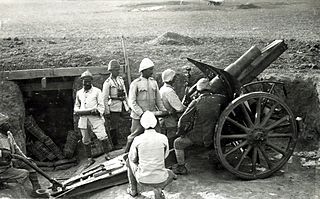
Picturesque Palestine, Sinai, and Egypt

Last updated
The cover of the first edition's Division I Picturesque Palestine, Division I.jpg
The cover of the first edition's Division I
Damascus Gate, the northern entrance to Jerusalem Damascus Gate P6080085.JPG
Damascus Gate, the northern entrance to Jerusalem
The Cave under the Great Rock on Mount Moriah, within the Dome of the Rock (then known as the "Mosque of Omar") Jerusalem dome of rock 2 1880.jpg
The Cave under the Great Rock on Mount Moriah , within the Dome of the Rock (then known as the "Mosque of Omar")
The Interior of the Dome of the Rock Jerusalem dome of rock 1880.jpg
The Interior of the Dome of the Rock
Russian pilgrims buying candles 022 Pilgrims buying candlessr.jpg
Russian pilgrims buying candles
The Six Columns of the Great Temple, Ba'albek Six Columns of the Great Temple, Baalbek.png
The Six Columns of the Great Temple, Ba'albek

Picturesque Palestine, Sinai, and Egypt was a lavishly illustrated set of books published by D. Appleton & Co. in the early 1880s based on their phenomenally successful Picturesque America and Picturesque Europe series. It was edited by Charles William Wilson, following his leadership of the seminal Ordnance Survey of Palestine and PEF Survey of Palestine. The Appleton series was issued as "two volumes or four divisions"; it was reprinted in London by J.S. Virtue & Co., simply published as four volumes.

Contents

It was followed in 1884 by Stanley Lane-Poole's Social Life in Egypt, a kind of sequel that billed itself as "a supplement to Picturesque Palestine". It is sometimes treated as a "fifth volume" of the series, [1] but did not use Fenn or Woodward for its art.

Publication

Charles Wilson, a Royal Engineer, had attempted to improve British military intelligence in an age when spying was seen as "ungentlemanly" or "work of a low order", [2] even successfully reducing his own role in order to get a general involved who would be able to defend the interests of the intelligence service. [3] Never a spy as such, he simply "went in openly", scouting and studying areas of military interest. [3] Throughout the 19th century, the Holy Land became increasingly important as a route between Europe and the Indian Ocean: important to Britain as a faster route to India and to other powers as way around the British-held choke point at Gibraltar. [4] He had visited Jerusalem in 1864, spending ten months producing the Ordnance Survey of Palestine with the help of local workers and even the Prussian consul. [5] He mixed research in Biblical archaeology with military and civilian intelligence about water courses and lines of defense. [5] In addition to grants from the Treasury, the detailed maps and photographs produced sold very well, earning a profit on the endeavor in their own right. [5] He then joined the Palestine Exploration Fund and directed the Survey of Western Palestine, which also acted as a "cover for military mapping". [6]

Unlike the earlier Picturesque series, Picturesque Palestine did not employ numerous artists on the project but only used two of the more successful artists from the earlier books, Harry Fenn and J.D. Woodward. Their sketches were compiled on site during Woodward and Fenn's two joint tours of Egypt and the Levant in the winters of 1877–78 and 1878–79. The two trips are documented in his correspondence with Woodward's wife and his mother. The pair received special permission to sketch inside and under the Mosque of Omar (the Dome of the Rock), [7] although Woodward compared the streets of Jerusalem with the "dirtiest alleys of Baltimore". Oppressed by the heat, glare, and barrenness, the best he could say about the shore of the Dead Sea was "I suppose it is not so bad it couldn't be worse". Nazareth was "the worst", [7] while he was most impressed by the Syrio-Roman ruins at Baalbek. [8]

The works were "enormously successful", [6] with Woodward and Fenn each earning an estimated US$10000 a year in royalties on the Holy Land volumes. [7]

Contents

Volume I

Division I

Division I was published separately and as part of Volume I in 1881. It included an introduction by Dean Stanley and sections on "Jerusalem" by Charles William Wilson; "Bethlehem and the North of Judaea" by Canon Henry Baker Tristram; and "The Mountains of Judah and Ephraim" by Lt. Claude Reignier Conder. [9] [10] It included steel engravings of Jerusalem from Scopus and from the Mount of Olives; the Dome of the Rock; Bethany; the Mount of Olives from Mount Zion; Bethlahem's Church of the Nativity; Mar Saba Monastery; the Plains of Jericho; the view from the Tomb of Samuel; and a threshing floor. [11] [12]

Division II

Division II was published separately and as part of Vol. I in 1881. It included sections on "Samaria and Plain of Esdraelon" by Mary Eliza Rogers; "Esdraelon and Nazareth" by Canon Tristram; "Galilee", "Northern Galilee", "Caesarea Philippi and the Highlands of Galilee", and "Mount Hermon and its Temples" by the American consul, Rev. Selah Merrill; "Damascus" by Philip Schaff; "Palmyra", "The Wady Barada", and "Ba'albek" by Samuel Jessup. [13] [14] It included steel engravings of Nablus; Mounts Tabor, Hermon, and Lebanon; the Valley of Nazareth; Tiberias; Caesarea Philippi; Damascus's rivers and streets; and Palmyra. [15] [12]

Volume II

Division III

Division III was published separately in 1881 and as part of Volume II in 1883. It included sections on "Phoenicia and Lebanon" by Henry W. Jessup; "The Phoenician Plain" by Canon Tristram; "Acre, the Key of Palestine", "Mount Carmel and the River Kishon", "Maritime Cities and the Plains of Palestine" by M.E. Rogers; "Lydda and Ramleh" and "Philistia" by Lt. Col. Warren; "The South Country of Judaea" by Canon Tristram; "The Southern Borderland and Dead Sea" by Prof. Palmer; and "Mount Hor and the Cliffs of Edom" and "The Covent of St. Catherine" by M.E. Rogers. [16] [17] It included steel engravings of the Kadisha Gorge; a well at Nazareth; a map of Palestine; Beirut's St George Bay; Sidon; Haifa and Mount Carmel; Caesarea; Jaffa; Hebron; and the entrance to the Valley of Petra. [18] [19]

Division IV

Division IV was published separately and as part of Vol. II in 1883. It included sections on "Sinai" by C. Pickering Clarke and on "The Land of Goshen", "Cairo", "Memphis", "Thebes", and "Edfû and Philae" by Stanley Lane-Poole. [20] [21] It included steel engravings of the Sea of Galilee; a map of Egypt and Sinai; Gaza; Tyre; El Hesweh; the Valley of Inscriptions; Mount Serbal; the Valley of Jethro; the Pyramids of Giza; Luxor; the Great Temple at Karnak; and Philae. [22] [19]

Supplements & translations

Social Life in Egypt was published in 1884 as "a supplement to Picturesque Palestine". [23] It included chapters on "The Townsfolk", "The Countryfolk", "School and Mosque", "The European Element", [24] and an epilogue which focused largely on the "disastrous results" of Egypt's "vicious training of women" as the primary stumbling block in the way of Egyptian prosperity. [25]

The series was translated into German as Palestine in Picture and Word (Palästina in Bild und Wort) with additional notes by the novelist and Egyptologist Georg Ebers [26] in 1884. [27] In 1882 and 1884, the artwork from Picturesque Palestine was also used for The Holy Land ( French : La Terre Sainte), a popular 2-volume [28] [29] abridgment of Victor Guérin's scholarly 7-volume Geographical, Historical, and Archaeological Description of Palestine. [30]

See also

Related Research Articles

<span class="mw-page-title-main">Jezreel Valley</span> Valley in Israel

The Jezreel Valley, or Marj Ibn Amir, also known as the Valley of Megiddo, is a large fertile plain and inland valley in the Northern District of Israel. It is bordered to the north by the highlands of the Lower Galilee region, to the south by the Samarian highlands, to the west and northwest by the Mount Carmel range, and to the east by the Jordan Valley, with Mount Gilboa marking its southern extent. The largest settlement in the valley is the city of Afula, which lies near its center.

<span class="mw-page-title-main">Sinai and Palestine campaign</span> Campaign of the Middle Eastern theatre of World War I

The Sinai and Palestine campaign of the Middle Eastern theatre of World War I was fought by the Arab Revolt and the British Empire, against the Ottoman Empire and its Imperial German allies. It started with an Ottoman attempt at raiding the Suez Canal in 1915, and ended with the Armistice of Mudros in 1918, leading to the cession of Ottoman Syria.

<span class="mw-page-title-main">Toron</span> Crusader castle in Lebanon

Toron, now Tibnin or Tebnine in southern Lebanon, was a major Crusader castle, built in the Lebanon mountains on the road from Tyre to Damascus. The castle was the centre of the Lordship of Toron, a seigneury within the Kingdom of Jerusalem, actually a rear-vassalage of the Principality of Galilee.

<span class="mw-page-title-main">Harry Fenn</span> English painter

Harry Fenn was an English-born American illustrator, landscape painter, etcher, and wood engraver. From 1870 to around 1895 he was the most prominent landscape illustrator in the United States. He is also noted for his illustrations of Egypt, Palestine and the Sinai.

<span class="mw-page-title-main">Merhavia (kibbutz)</span> Place in Northern, Israel

Merhavia is a kibbutz in northern Israel. Located to the east of Afula, it falls under the jurisdiction of Jezreel Valley Regional Council. In 2021 it had a population of 1,299.

<span class="mw-page-title-main">Tell es-Safi</span> Place in Hebron, Mandatory Palestine

Tell es-Safi was an Arab Palestinian village, located on the southern banks of Wadi 'Ajjur, 35 kilometers (22 mi) northwest of Hebron which had its Arab population expelled during the 1948 Arab–Israeli war on orders of Shimon Avidan, commander of the Givati Brigade.

<i>Picturesque Europe</i>

Picturesque Europe was a lavishly illustrated set of books published by D. Appleton & Co. in the mid-1870s based on their phenomenally successful Picturesque America. An edited form was reprinted in Europe by Cassell & Co. The books depicted nature and tourist haunts in Europe, with text descriptions and numerous steel and wood engravings. J.W. Whymper was among the engravers and directed the other artists on the project.

<i>Picturesque America</i>

Picturesque America was a two-volume set of books describing and illustrating the scenery of America, which grew out of an earlier series in Appleton's Journal. It was published by D. Appleton and Company of New York in 1872 and 1874 and edited by the romantic poet and journalist William Cullen Bryant (1794-1878), who also edited the New York Evening Post. The layout and concept was similar to that of Picturesque Europe. The work's essays, together with its nine hundred wood engravings and fifty steel engravings, are considered to have had a profound influence on the growth of tourism and the historic preservation movement in the United States. The preface described "the design of this publication to present full descriptions and elaborate pictorial delineations of the scenery characteristic of all the different parts of our country. The wealth of material for this purpose is almost boundless."

<span class="mw-page-title-main">John Douglas Woodward</span> American painter

John Douglas Woodward, usually simply J.D. or Douglas Woodward, was an American landscape artist and illustrator. He was one of the country's "best-known painters and illustrators". He produced hundreds of scenes of the United States, Northern Europe, the Holy Land, and Egypt, many of which were reproduced in popular magazines of the day.

<span class="mw-page-title-main">Victor Guérin</span> French archaeologist, geographer and explorer of Palestine, Greece and North Africa

Victor Guérin was a French intellectual, explorer and amateur archaeologist. He published books describing the geography, archeology and history of the areas he explored, which included Greece, Asia Minor, North Africa, Lebanon, Syria and Palestine.

<span class="mw-page-title-main">Timeline of the Palestine region</span> Timeline of major events in Palestine

The timeline of the Palestine region is a timeline of major events in the history of Palestine. For more details on the history of Palestine see History of Palestine. In cases where the year or month is uncertain, it is marked with a slash, for example 636/7 and January/February.

<span class="mw-page-title-main">Battle of Sharon</span> First World War battle (September 1918)

The Battle of Sharon fought between 19 and 25 September 1918, began the set piece Battle of Megiddo half a day before the Battle of Nablus, in which large formations engaged and responded to movements by the opposition, according to pre-existing plans, in the last months of the Sinai and Palestine Campaign of World War I. The fighting took place over a wide area from the Mediterranean Sea east to the Rafat salient in the Judean Hills. Here the Egyptian Expeditionary Force (EEF) XXI Corps with the French brigade sized Détachement Français de Palestine et de Syrie attacked the Yildirim Army Group Eighth Army's XXII Corps and German Asia Corps. The Battle of Sharon extended well behind the Ottoman front lines when the Desert Mounted Corps rode through a gap in the front line across the Plain of Sharon to occupy the Esdraelon Plain. Meanwhile, during the Battle of Nablus the XX Corps attacked Nablus while Chaytor's Force held the right flank in the Jordan Valley before advancing to secure bridges and fords across the Jordan River, to continue the encirclement the defenders in the Judean Hills. Subsequently, Chaytor's Force advanced against the Fourth Army to capture Es Salt and Amman after the Second Battle of Amman.

<span class="mw-page-title-main">Battle of Nazareth</span> Battle fought during the last months of the Sinai and Palestine Campaign of the First World War

The Battle of Nazareth began on 20 September 1918, during the Battle of Sharon, which together with the Battle of Nablus formed the set piece Battle of Megiddo fought during the last months of the Sinai and Palestine Campaign of the First World War. During the cavalry phase of the Battle of Sharon the Desert Mounted Corps rode to the Esdraelon Plain 40 and 50 miles behind the front line in the Judean Hills. At Nazareth on the plain, the 13th Cavalry Brigade of the 5th Cavalry Division attempted to capture the town and the headquarters of the Yildirim Army Group which was eventually captured the following day after the garrison had withdrawn.

<span class="mw-page-title-main">Mar Elias Monastery</span> Monastery in Jerusalem, Israel

Mar Elias Monastery is a Greek Orthodox monastery in south Jerusalem, on a hill overlooking Bethlehem and Herodium, near Hebron Road.

The Capture of Afula and Beisan occurred on 20 September 1918, during the Battle of Sharon which together with the Nablus, formed the set piece Battle of Megiddo fought during the last months of the Sinai and Palestine Campaign of the First World War. During the cavalry phase of the Battle of Sharon, the 4th Cavalry Division of the Desert Mounted Corps attacked and captured the main communications hub at Afula, located in the centre of the Esdraelon Plain, and Beisan on the plain's eastern edge near the Jordan River, some 40–50 miles (64–80 km) behind the front line in the Judean Hills.

<span class="mw-page-title-main">Capture of Jenin</span> Part of the Middle Eastern theatre of World War I

The Capture of Jenin occurred on 20 September 1918, during the Battle of Sharon which together with the Battle of Nablus formed the set piece Battle of Megiddo fought between 19 and 25 September during the last months of the Sinai and Palestine Campaign of the First World War. During the cavalry phase of the Battle of Sharon carried out by the Desert Mounted Corps, the 3rd Light Horse Brigade, Australian Mounted Division attacked and captured the town of Jenin located on the southern edge of the Esdraelon Plain 40–50 miles (64–80 km) behind the front line in the Judean Hills. The Australian light horse captured about 2,000 prisoners, the main supply base and the ordnance depot of the Seventh and the Eighth Armies in and near the town. They also cut the main road from Nablus and a further 6,000 Ottoman Empire and German Empire prisoners, were subsequently captured as they attempted to retreat away from the Judean Hills.

<span class="mw-page-title-main">Capture of Tiberias (1918)</span> Part of the Middle Eastern theatre of World War I

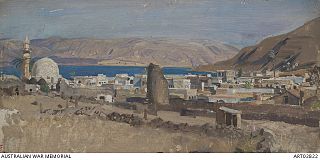
The Capture of Tiberias took place on 25 September 1918 during the Battle of Sharon which together with the Battle of Nablus formed the set piece Battle of Megiddo fought between 19 and 25 September in the last months of the Sinai and Palestine Campaign of the First World War. During the cavalry phase of the Battle of Sharon the Desert Mounted Corps occupied the Esdraelon Plain 40–50 miles (64–80 km) behind the front line in the Judean Hills. One squadron from each of the 3rd and 4th Light Horse Brigades Australian Mounted Division attacked and captured Tiberias, along with the Yildirim Army Group's Ottoman and German garrison.

<span class="mw-page-title-main">Hebbariye</span> Place in Nabatieh Governorate, Lebanon

Hebbariye, Hebbariyeh, Hebbariya or Hebariya is a village and municipality situated in the Hasbaya District of the Nabatieh Governorate in Lebanon. It is located on the southwestern slopes of Mount Hermon near the Lebanon–Syria border, northeast of Rachaya Al Foukhar and is positioned amongst orchards of apricot trees. There it is a roman temple.

<span class="mw-page-title-main">Travelogues of Palestine</span> Descriptions of the region of Palestine by travellers

Travelogues of Palestine are the written descriptions of the region of Palestine by travellers, particularly prior to the 20th century. The works are important sources in the study of the history of Palestine and of Israel. Surveys of the geographical literature on Palestine were published by Edward Robinson in 1841, Titus Tobler in 1867 and subsequently by Reinhold Röhricht in 1890. Röhricht catalogued 177 works between 333 – 1300 CE, 19 works in the 14th century, 279 works in the 15th century, 333 works in the 16th century, 390 works in the 17th century, 318 works in the 18th century and 1,915 works in the 19th century.

<span class="mw-page-title-main">PEF Survey of Palestine</span> 1872–1877 and 1880 map surveys

The PEF Survey of Palestine was a series of surveys carried out by the Palestine Exploration Fund (PEF) between 1872 and 1877 for the Survey of Western Palestine and in 1880 for the Survey of Eastern Palestine. The survey was carried out after the success of the Ordnance Survey of Jerusalem by the newly-founded PEF, with support from the War Office. Twenty-six sheets were produced for "Western Palestine" and one sheet for "Eastern Palestine". It was the first fully scientific mapping of Palestine.

References

Citations

Bibliography