
Dacia was the land inhabited by the Dacians, its core in Transylvania, stretching to the Danube in the south, the Black Sea in the east, and the Tisza in the west. The Carpathian Mountains were located in the middle of Dacia. It thus roughly corresponds to present-day Romania, as well as parts of Moldova, Bulgaria, Serbia, Hungary, Slovakia, and Ukraine.

Pietroasele is a commune in Buzău County, Muntenia, Romania, known for its vineyards. The name means "the rockies". The commune is composed of six villages: Câlțești, Clondiru de Sus, Dara, Pietroasa Mică, Pietroasele and Șarânga. It became famous with the discovery in 1837 of the Pietroasa Treasure composed of several pieces of gold and precious stones. The Romanian historian Alexandru Odobescu wrote a book on the archaeological discovery.

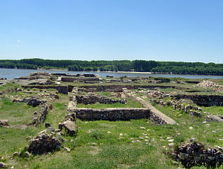
Porolissum was an ancient Roman city in Dacia. Established as a military fort in 106 during Trajan's Dacian Wars, the city quickly grew through trade with the native Dacians and became the capital of the province Dacia Porolissensis in 124. The site is one of the largest and best-preserved archaeological sites in modern-day Romania. It is 8 km away from the modern city of Zalău, in Moigrad-Porolissum village, Mirsid Commune, Sălaj County.

Sucidava was a Dacian and Daco-Roman city situated in Corabia, Romania, on the north bank of the Danube. It developed from the 270s AD and especially after the construction of Constantine's Bridge the northern side of which it protected.

The Moesian Limes is the modern term given to a linked series of Roman forts on the northern frontier of the Roman province of Moesia along the Danube between the Black Sea shore and Pannonia and dating from the 1st century AD. It was the eastern section of the so-called Danubian Limes and protected the Roman provinces of Upper and Lower Moesia south of the river. The eastern section is often called the limes Scythiae minoris as it was located in the late Roman province of Scythia Minor.
Limes Transalutanus is the modern name given to a fortified frontier system of the Roman Empire, built on the western edge of Teleorman's forests as part of the Dacian Limes in the Roman province of Dacia, modern-day Romania.
Capidava was an important Geto-Dacian centre on the right bank of the Danube. After the Roman conquest, it became a civil and military centre, as part of the province of Moesia Inferior and was part of the defensive frontier system of the Limes Moesiae along the Danube.

The castra of Bulci was a fort in the Roman province of Dacia located on the western side of defensive line of forts, limes Daciae. Its ruins are located in Bulci.

Angustia was a fort in the Roman province of Dacia in the 2nd and 3rd centuries AD today near the town of Breţcu, Romania.

Castra Buridava was a fort in the Roman province of Dacia, part of the frontier system of the Limes Alutanus, and near the Dacian and Roman town of Buridava.
Morisena was a castra in the Roman province of Dacia. Morisena was a Roman auxiliary camp and part of the outline in the western fortress chain of the Dacian Limes. It was located within the modern municipality of Cenad, Romania.

The castra of Hoghiz was a fort in the Roman province of Dacia. The fort was built in the 2nd century AD, on the left bank of the Olt River, at a place where a Dacian settlement existing already in the 2nd century BC was unearthed. The fort and the nearby village were abandoned in the 3rd century AD. The ruins of the castra are located in Hoghiz, Romania.

The castra of Olteni was a fort in the Roman province of Dacia. It was built in the 2nd century AD. The archaeological site yielded coins issued by the Roman emperors Titus Flavius Vespasianus, Domitian, Trajan, Antoninus Pius, Elagabal and Alexander Severus. The fort was abandoned in the 3rd century. It ruins are located in Olteni in commune Bodoc in Romania.
The castra of Aradul Nou was a fort in the Roman province of Dacia, located on the western side of the defensive line of forts, limes Daciae. It is situated near Arad, Romania.
The castra of Bucium was a fort in the Roman province of Dacia in the 2nd and 3rd centuries AD. Its ruins are located in Bucium.
The castra of Drumul Carului was a fort in the Roman province of Dacia near Moieciu, Romania.

Gresia Roman fort is located in the present Gresia. It was in the Roman province of Dacia and dates from the 2nd and 3rd centuries AD. It was part of the frontier system of the Limes Transalutanus.
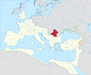
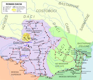
Roman Dacia was a province of the Roman Empire from 106 to 271–275 AD. Its territory consisted of what are now the regions of Oltenia, Transylvania and Banat. During Roman rule, it was organized as an imperial province on the borders of the empire. It is estimated that the population of Roman Dacia ranged from 650,000 to 1,200,000. It was conquered by Trajan (98–117) after two campaigns that devastated the Dacian Kingdom of Decebalus. However, the Romans did not occupy its entirety; Crișana, Maramureș, and most of Moldavia remained under the Free Dacians.
This section of the timeline of Romanian history concerns events from Late Neolithic until Late Antiquity, which took place in or are directly related with the territory of modern Romania.

The Dacian Limes is the generic modern term given to a collection of ramparts and linked series of Roman forts on the frontiers of the Roman province of Dacia dating from the early 2nd century AD. They ran for about 1,000 km and included the:


