Trondheim, historically Kaupangen, Nidaros, and Trondhjem, is a city and municipality in Trøndelag county, Norway. As of 2022, it had a population of 212,660. Trondheim is the third most populous municipality in Norway, and is the fourth largest urban area. Trondheim lies on the south shore of Trondheim Fjord at the mouth of the River Nidelva. Among the significant technology-oriented institutions headquartered in Trondheim are the Norwegian University of Science and Technology (NTNU), the Foundation for Scientific and Industrial Research (SINTEF), the Geological Survey of Norway (NGU), and St. Olavs University Hospital.

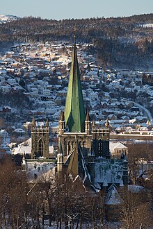
Nidaros Cathedral is a Church of Norway cathedral located in the city of Trondheim in Trøndelag county. It is built over the burial site of King Olav II, who became the patron saint of the nation, and is the traditional location for the consecration of new kings of Norway. It was built over a 230-year period, from 1070 to 1300 when it was substantially completed. However additional work, additions and renovations have continued intermittently since then, including a major reconstruction starting in 1869 and completed in 2001.

Olaf II Haraldsson, also Olav Haraldsson, later known as Saint Olaf and Olaf the Holy, was King of Norway from 1015 to 1028. Son of Harald Grenske, a petty king in Vestfold, Norway, he was posthumously given the title Rex Perpetuus Norvegiae and canonised at Nidaros (Trondheim) by Bishop Grimketel, one year after his death in the Battle of Stiklestad on 29 July 1030. His remains were enshrined in Nidaros Cathedral, built over his burial site. His sainthood encouraged the widespread adoption of Christianity by Scandinavia's Vikings/Norsemen.

Dovre is a municipality in Innlandet county, Norway. It is located in the traditional district of Gudbrandsdal. The administrative centre of the municipality is the village of Dovre. Other villages in Dovre include Dombås and Hjerkinn. The municipality is bordered on the north by Oppdal municipality, on the east by Folldal, on the south by Sel and Vågå, and on the northwest by Lesja. The highest peak in the municipality is Snøhetta at a height of 2,286 metres (7,500 ft).

Lesja is a municipality in Innlandet county, Norway. It is located in the traditional district of Gudbrandsdal. The administrative centre of the municipality is the village of Lesja. Other villages in the municipality include Bjorli, Lesjaskog, Lesjaverk, and Lora.

is a municipality in Trøndelag county, Norway. It is part of the Dovre region. The administrative centre of the municipality is the village of Oppdal. Other villages in the municipality include Lønset, Vognillan, Fagerhaug, and Holan. The Oppdal Airport, Fagerhaug is located in the northeastern part of the municipality.
Nidaros, Niðarós or Niðaróss was the medieval name of Trondheim when it was the capital of Norway's first Christian kings. It was named for its position at the mouth of the River Nid.

Gudbrandsdalen is a valley and traditional district in the Norwegian county of Innlandet. The valley is oriented in a north-westerly direction from Lillehammer and the lake of Mjøsa, extending 230 kilometers (140 mi) toward the Romsdalen valley. The river Gudbrandsdalslågen (Lågen) flows through the valley, starting from the lake Lesjaskogsvatnet and ending at the lake Mjøsa. The Otta river which flows through Otta valley is a major tributary to the main river Lågen. The valleys of the tributary rivers such as Otta and Gausa (Gausdal) are usually regarded as part of Gudbrandsdalen. The total area of the valley is calculated from the areas of the related municipalities. Gudbrandsdalen is the main valley in a web of smaller valleys. On the western side there are long adjacent valleys: Ottadalen stretches 100 kilometers (62 mi) from Otta village, Gausdal some 50 kilometers (31 mi) from Lillehammer and Heidal some 40 kilometers (25 mi) from Sjoa. Gudbrandsdalen runs between the major mountain ranges of Norway including Jotunheimen and Dovrefjell–Rondane.

Dovrefjell is a mountain range in Central Norway that forms a natural barrier between Eastern Norway and Trøndelag. The mountain range is located in Innlandet, Møre og Romsdal, and Trøndelag counties in Norway. As a result of its central location, its valleys and passes have been heavily trafficked during and probably preceding historical times. Several mountain inns were established in the Middle Ages to house pilgrims traveling through Dovrefjell to Trondheim, and there are even ruins of an old leper colony in the northern area of it.

is a village or small town in Dovre Municipality in northern Innlandet county, Norway. The village serves as the commercial centre for the upper Gudbrandsdalen valley. It lies at an important junction of roads with the European route E6 highway heading north and south connecting the cities of Oslo and Trondheim and the European route E136 highway heading west to Åndalsnes. The Dovrebanen and Raumabanen railway lines meet in the village at Dombås Station as well. Dombås Church is located in the village.

Lesjaverk is a village in Lesja Municipality in Innlandet county, Norway. It lies in the upper Gudbrandsdal valley approximately 35 kilometres (22 mi) northwest of Dombås and about 11 kilometres (6.8 mi) east of the village of Lesjaskog. The village lies along the European route E136 highway and the Raumabanen railway line. The E136 highway goes from Ålesund up through the Romsdalen valley and passes through Lesjaverk on the way to its end point at Dombås. Located in a high mountain pass at 633 metres (2,077 ft) in elevation, the village is situated between several mountains including the 1,883-metre (6,178 ft) tall Svarthøi, the 1,868-metre (6,129 ft) tall Storhøi, and the 1,702-metre (5,584 ft) tall Merratind which all are part of the Dovrefjell range to the north. The 1,780-metre (5,840 ft) tall mountain Digervarden lies to the south on the other side of the valley.

The Driva river runs through Trøndelag and Møre og Romsdal counties in Norway. The headwaters lie in the Dovrefjell mountains in the south, from where it flows northward, downward through the Drivdalen valley in the municipality of Oppdal. When the river gets to the village of Oppdal, it turns westward and heads down the Sunndalen valley to the Sunndalsfjord at the village of Sunndalsøra in the municipality of Sunndal. Some of the other villages along the river include Grøa, Hoelsand, Lønset, and Vognillan. The Norwegian National Road 70 follows the river for most of its course.

Kongsvoll is a historic mountain lodge built on the site of a former inn located in the Drivdalen valley in the municipality of Oppdal in Trøndelag county, Norway. The original inn dated to the 12th century. The oldest buildings of the present mountain lodge date from the 18th century.

Trondheim Central Station or Trondheim S is the main railway station serving the city of Trondheim, Norway. Located at Brattøra in the north part of the city centre, it is the terminus of the Dovre Line, running southwards, and the Nordland Line, which runs north. The railway is electrified south of the station but not north of it, so through trains must change locomotives at the station.

The Battle of Dombås was fought between Norwegian Army infantry forces and German Fallschirmjäger paratroops in mid-April 1940. As part of their conquest of Norway south of Trondheim, and as a countermeasure against reported Allied landings in the Romsdal area of south-western Norway, the Germans dropped a company of paratroopers near the vital railroad junction of Dombås on 14 April 1940. For the next five days, the German force blocked the Dovre Line railroad line between Oslo and Trondheim, as well as the main road between the two cities.

Kongsvoll Station is a railway station located at Kongsvoll in the municipality of Oppdal in Trøndelag county, Norway. It's located in the Drivdalen valley, along the Driva river and the European route E06 highway.

Hjerkinn is a village in the municipality of Dovre in Innlandet county in Norway. The village is located in the Dovrefjell mountains, about 30 kilometres (19 mi) northeast of Dombås and about 25 kilometres (16 mi) northwest of the village of Folldal. It is one of the driest places in the country, with only 222 millimetres (8.7 in) annual precipitation in the 10-year period 1905-14.

Sør-Trøndelag was a county comprising the southern portion of the present-day Trøndelag county in Norway. It bordered the old Nord-Trøndelag county as well as the counties of Møre og Romsdal, Oppland, and Hedmark. To the west is the Norwegian Sea, and to the east is Jämtland in Sweden. The county was separated into a northern and southern part by the Trondheimsfjord. Slightly over 200,000 of the county's population lives in the city of Trondheim and its suburbs. The Norwegian dialect of the region is Trøndersk.

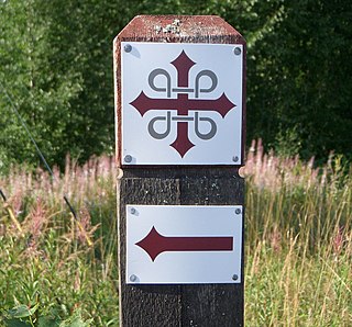
Kystpilgrimsleia, Norwegian for "Coastal Pilgrim Route", is the name of the pilgrim way that runs along the west coast of Norway and culminates at the Nidaros Cathedral in Trondheim. Kystpilgrimsleia is a joint project between four counties and four diocese to create a comprehensive and sustainable tourism product that promotes cultural heritage and provides a unique experience of more all the fjords of Norway.

St. Olavsleden, is a pilgrim's way between Selånger outside Sundsvall in Sweden and Nidaros Cathedral in Trondheim in Norway, commemorating Saint Olaf who was King of Norway from 1015 to 1028. St. Olavsleden was one of the Pilgrim's Routes. From the 1970s until 2012, it was called the Mittnordenleden.


