
Adams County is a county located in the U.S. state of Mississippi. As of the 2020 census, the population was 29,538. The county seat is Natchez. The county is the first to have been organized in the former Mississippi Territory. It is named for the second President of the United States, John Adams, who held that office when the county was organized in 1799. Adams County is part of the Natchez micropolitan area which consists of Adams County, Mississippi and Concordia Parish, Louisiana.

Union County is a county located in the U.S. state of South Carolina. As of the 2020 census, the population was 27,244. Its county seat is Union. The county was created in 1785.
Wilkinson County is a county located in the southwest corner of the U.S. state of Mississippi. As of 2020, its population was 8,587. Its county seat is Woodville. Bordered by the Mississippi River on the west, the county is named for James Wilkinson, a Revolutionary War military leader and first governor of the Louisiana Territory after its acquisition by the United States in 1803.

Simpson County is a county located in the U.S. state of Mississippi. Its western border is formed by the Pearl River, an important transportation route in the 19th century. As of the 2020 census, the population was 25,949. The county seat is Mendenhall. The county is named for Josiah Simpson (1787-1817), a territorial judge who also served as a delegate to Mississippi's Constitutional Convention.

Pike County is a county located on the southwestern border of the U.S. state of Mississippi. As of the 2020 census, the population was 40,324. The county seat is Magnolia. Pike County is named for explorer Zebulon Pike. Pike County is part of the McComb, MS Micropolitan Statistical Area.

Franklin County is a county located in the U.S. state of Mississippi. As of the 2020 census, the population was 7,675. Its county seat is Meadville. The county was formed on December 21, 1809, from portions of Adams County and named for Founding Father Benjamin Franklin. It is bisected by the Homochitto River, which runs diagonally through the county from northeast to southwest.

Pinckneyville is a city in and the county seat of Perry County, Illinois, United States. The population was 5,066 at the 2020 census. It is named for Charles Cotesworth Pinckney, an early American diplomat and presidential candidate.

Summit is a town in Pike County, Mississippi, United States. The population was 1,705 at the 2010 census. It is part of the McComb, Mississippi Micropolitan Statistical Area.

Pearl is a city located in Rankin County, Mississippi, United States, on the east side of the Pearl River across from the state capital Jackson. The population was 27,115 as of the 2020 census. It is part of the Jackson Metropolitan Statistical Area.
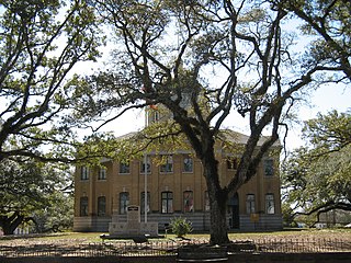
Woodville is one of the oldest towns in Mississippi and is the county seat of Wilkinson County, Mississippi, United States. Its population as of 2020 was 928.

Centreville is a town in Amite and Wilkinson counties, Mississippi, United States. It is part of the McComb, Mississippi micropolitan statistical area. Its population was 1,258 in 2020.

Crosby is a town in Amite and Wilkinson counties, Mississippi, United States. It is part of the McComb, Mississippi micropolitan statistical area. Its population was 242 at the 2020 census.

Minter City is an unincorporated community in Leflore County and Tallahatchie County, Mississippi. It is part of the Greenwood, Mississippi micropolitan area, and is within the Mississippi Delta.
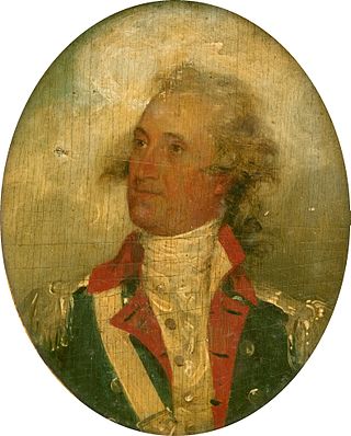
Thomas Pinckney was an American statesman, diplomat, and military officer who fought in both the American Revolutionary War and the War of 1812, achieving the rank of major general. He served as Governor of South Carolina and as the U.S. minister to Great Britain.
Foxworth is an unincorporated community and census-designated place (CDP) in Marion County, Mississippi, United States. As of the 2020 census, it had a population of 523.

Eastabuchie is a census-designated place and unincorporated community in southwestern Jones County, Mississippi. It is located along U.S. Route 11, just north of the Forrest County line. the community has a post office with the ZIP code 39436. Eastabuchie is part of the Laurel Micropolitan Statistical Area.

Southwest Mississippi Community College is a public community college in unincorporated Pike County, Mississippi, near Summit.
Camden is an unincorporated community located on Mississippi Highway 17 in Madison County, Mississippi, United States. Camden is located approximately 12 miles (19 km) northeast of Sharon and is located within the Jackson Metropolitan Statistical Area.
Fernwood is a census-designated place and unincorporated community in Pike County, Mississippi, United States. Its ZIP code is 39635.

Pinckneyville is a historic frontier settlement site located near Union, Union County, South Carolina. Pinckneyville was established on February 19, 1791, by the General Assembly of South Carolina Act #1491 along with the Washington district, and is one of the earliest settlements in the South Carolina backcountry. Pinckneyville was named for Charles Cotesworth Pinckney. Pinckneyville was chosen because it was central to Union County, but Union was the seat of power.


