
Thurston Island is an ice-covered, glacially dissected island, 215 km (134 mi) long, 90 km (56 mi) wide and 15,700 km2 (6,062 sq mi) in area, lying a short way off the northwest end of Ellsworth Land, Antarctica. It is the third-largest island of Antarctica, after Alexander Island and Berkner Island.
The Churchill Mountains are a mountain range group of the Transantarctic Mountains System, located in the Ross Dependency region of Antarctica. They border on the western side of the Ross Ice Shelf, between Byrd Glacier and Nimrod Glacier.
The UK Antarctic Place-Names Committee is a United Kingdom government committee, part of the Foreign and Commonwealth Office, responsible for recommending names of geographical locations within the British Antarctic Territory (BAT) and the South Georgia and the South Sandwich Islands (SGSSI). Such names are formally approved by the Commissioners of the BAT and SGSSI respectively, and published in the BAT Gazetteer and the SGSSI Gazetteer maintained by the Committee. The BAT names are also published in the international Composite Gazetteer of Antarctica maintained by SCAR.

Coronation Island is the largest of the South Orkney Islands, 25 nautical miles (46 km) long and from 3 to 8 nautical miles wide. The island extends in a general east–west direction, is mainly ice-covered and comprises numerous bays, glaciers and peaks, the highest rising to 1,265 metres (4,150 ft).
Lützow-Holm Bay is a large bay, about 220 kilometres (120 nmi) wide, indenting the coast of Queen Maud Land in Antarctica between Riiser-Larsen Peninsula and the coastal angle immediately east of the Flatvaer Islands. It was discovered by Captain Hjalmar Riiser-Larsen in two airplane flights from his expedition vessel, the Norvegia, on February 21 and 23, 1931. The name honours Commander Finn Lützow-Holm of the Royal Norwegian Navy Air Service, a pilot for Captain Riiser-Larsen on the Aagaard in 1935.

Mound Township is one of twelve townships in Warren County, Indiana, United States. According to the 2010 census, its population was 418 and it contained 183 housing units.

Hut Point Peninsula is a long, narrow peninsula from 3 to 5 km wide and 24 km (15 mi) long, projecting south-west from the slopes of Mount Erebus on Ross Island, Antarctica. McMurdo Station (US) and Scott Base (NZ) are Antarctic research stations located on the Hut Point Peninsula.

Annenkov Island is to the west of the main island of South Georgia. The Pickersgill Islands are to its southeast. It is irregularly shaped and 4 miles (6.4 km) long and 650 m (2,130 ft) high, lying 8 miles (13 km) off the south-central coast of South Georgia.

The Bay of Isles is a bay 9 miles (14 km) wide and receding 3 miles (5 km), lying between Cape Buller and Cape Wilson along the north coast of South Georgia. It was discovered in 1775 by a British expedition under James Cook and so named by him because numerous islands lie in the bay. Of South Georgia's 31 breeding bird species, 17 are found here.
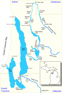
The Elk River Chain of Lakes Watershed is a 75-mile-long (121 km) waterway consisting of 14 lakes and connecting rivers in the northwestern section of the Lower Peninsula of the U.S. state of Michigan, which empty into Lake Michigan.
Tomkins Mountain is a mountain in the North Carolina High Country, near the community of Deep Gap. The majority of the mountain is within the Blue Ridge Parkway. Its elevation reaches 4,075 feet (1,242 m) and it also marks the corner between Ashe, Watauga, and Wilkes counties.

Possum Trot is an unincorporated community in Highland County, Virginia, United States. The community is located 4.7 miles (7.6 km) northeast of Monterey, Virginia and 2.1 miles (3.4 km) southeast of Blue Grass, Virginia on State Route 635. Possum Trot is cradled by the long ridge line of Monterey Mountain to the west and Ginseng Mountain to the north.
Sibley is an unincorporated community in Adams County, Mississippi, United States. There is a post office located on U.S. Route 61 in Sibley, ZIP code 39165.
Hutchins Landing is a ghost town in Adams County, Mississippi, United States.
Leggo is a ghost town in Yalobusha County, Mississippi, United States.
Reid is an unincorporated community in Calhoun County, Mississippi, United States.

The San Luis Hills are a group of small mountain ranges in Conejos and Costilla counties in the San Luis Valley in southern Colorado. The individual mountain ranges that make up the San Luis Hills include the Fairy Hills, the Brownie Hills, the Piñon Hills, and the South Piñon Hills. The San Luis Hills' highest point is Flat Top, elevation 9,206 feet

