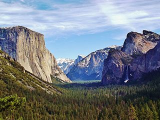
Yosemite Valley is a glacial valley in Yosemite National Park in the western Sierra Nevada mountains of Central California. The valley is about 7.5 mi (12.1 km) long and 3,000–3,500 ft (910–1,070 m) deep, surrounded by high granite summits such as Half Dome and El Capitan, and densely forested with pines. The valley is drained by the Merced River, and a multitude of streams and waterfalls flow into it, including Tenaya, Illilouette, Yosemite and Bridalveil Creeks. Yosemite Falls is the highest waterfall in North America and is a big attraction especially in the spring, when the water flow is at its peak. The valley is renowned for its natural environment and is regarded as the centerpiece of Yosemite National Park.

The Wabash River is a 503-mile-long (810 km) river that drains most of the state of Indiana in the United States. It flows from the headwaters in Ohio, near the Indiana border, then southwest across northern Indiana turning south near the Illinois border, where the southern portion forms the Indiana-Illinois border before flowing into the Ohio River.

The New River is a river which flows through the U.S. states of North Carolina, Virginia, and West Virginia before joining with the Gauley River to form the Kanawha River at the town of Gauley Bridge, West Virginia. Part of the Ohio River watershed, it is about 360 miles (580 km) long.

The Trinity River is a 710-mile (1,140 km) river, the longest with a watershed entirely within the U.S. state of Texas. It rises in extreme northern Texas, a few miles south of the Red River. The headwaters are separated by the high bluffs on the southern side of the Red River.

White Clay Creek is an 18.5-mile-long (29.8 km) tributary of the Christina River in southern Pennsylvania and northern Delaware in the United States. It is renowned for its scenic character and is largely federally protected.

Conococheague Creek, a tributary of the Potomac River, is a free-flowing stream that originates in Pennsylvania and empties into the Potomac River near Williamsport, Maryland. It is 80 miles (129 km) in length, with 57 miles (92 km) in Pennsylvania and 23 miles (37 km) in Maryland. The watershed of Conococheague Creek has an area of approximately 566 square miles (1,470 km2), out of which only 65 square miles (170 km2) are in Maryland.

Tohickon Creek is a 29.5-mile-long (47.5 km) tributary of the Delaware River. Located entirely in Bucks County, in southeastern Pennsylvania, it rises in Springfield Township and has its confluence with the Delaware at Point Pleasant. It is dammed to form Lake Nockamixon.
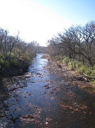
The Zumbro River is a tributary of the Mississippi River in the Driftless Area of southeastern Minnesota in the United States. It is 64.6 miles (104.0 km) long from the confluence of its principal tributaries and drains a watershed of 1,428 square miles (3,700 km2). The river's name in English is a change from its French name Rivière des Embarras due to its mouth near Pine Island in the Mississippi River; the pronunciation changed from [dez‿ɑ̃.ba.ʁɑ] to. The Dakota name for this river is Wapka Wazi Oju, having reference to the grove of great white pines at Pine Island.

Judge C. R. Magney State Park is a state park in the U.S. state of Minnesota, on the North Shore of Lake Superior. It was named for Clarence R. Magney, a former mayor of Duluth and justice of the Minnesota Supreme Court, who was instrumental in getting 11 state parks and scenic waysides established along the North Shore. The park is best known for the Devil's Kettle, an unusual waterfall and rock formation in which half of the Brule River disappears into a pothole.

The Eel River Athabaskans include the Wailaki, Lassik, Nongatl, and Sinkyone (Sinkine) groups of Native Americans that traditionally live in present-day Mendocino, Trinity, and Humboldt counties on or near the Eel River and Van Duzen River of northwestern California.

Bishop Creek is a 10.1-mile-long (16.3 km) stream in Inyo County, California. It is the largest tributary of the Owens River. It has five hydroelectric plants owned by Southern California Edison, Bishop Creek #2–6. Bishop Creek #1 was never completed. Parts of the creek run through pipelines, or penstocks, to increase output at the power plants.

Oak Creek Canyon is a river gorge located in northern Arizona between the cities of Flagstaff and Sedona. The canyon is often described as a smaller cousin of the Grand Canyon because of its scenic beauty. State Route 89A enters the canyon on its north end via a series of hairpin turns before traversing the bottom of the canyon for about 13 miles (21 km) until the highway enters the town of Sedona.

Octoraro Creek is a 22.1-mile-long (35.6 km) tributary of the Susquehanna River, joining it 9 miles (14 km) above the Susquehanna's mouth at Chesapeake Bay. The Octoraro rises as an East and West Branch in Pennsylvania. The East Branch and Octoraro Creek form the southern half of the border between Lancaster and Chester counties until the creek crosses the Mason-Dixon line. It winds through northwestern Cecil County, Maryland before joining the Susquehanna.
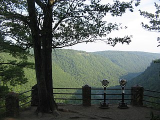
Colton Point State Park is a 368-acre (149 ha) Pennsylvania state park in Tioga County, Pennsylvania, in the United States. It is on the west side of the Pine Creek Gorge, also known as the Grand Canyon of Pennsylvania, which is 800 feet (240 m) deep and nearly 4,000 feet (1,200 m) across at this location. The park extends from the creek in the bottom of the gorge up to the rim and across part of the plateau to the west. Colton Point State Park is known for its views of the Pine Creek Gorge, and offers opportunities for picnicking, hiking, fishing and hunting, whitewater boating, and camping. Colton Point is surrounded by Tioga State Forest and its sister park, Leonard Harrison State Park, on the east rim. The park is on a state forest road in Shippen Township 5 miles (8 km) south of U.S. Route 6.
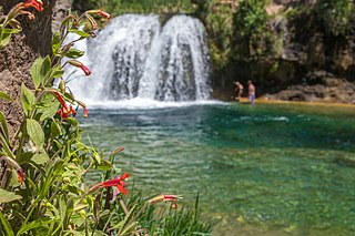
Fossil Creek is a perennial stream accessed by forest roads near the community of Camp Verde in the U.S. state of Arizona. Primary access is from Forest Road 708 off Arizona State Route 260 east of Camp Verde. A tributary of the Verde River, Fossil Creek flows from its headwaters on the Mogollon Rim to meet the larger stream near the former Childs Power Plant.

White Pines Forest State Park, more commonly referred to as White Pines State Park, is an Illinois state park in Ogle County, Illinois. It is located near the communities of Polo, Mount Morris and Oregon. The 385-acre (156 ha) park contains the southernmost remaining stand of native white pine trees in the state of Illinois, and that area, 43 acres (17 ha), was designated an Illinois Nature Preserve in 2001.
Rock Creek is a 24.7-mile-long (39.8 km) tributary of the Kankakee River in the U.S. state of Illinois. It empties into the Kankakee River in Kankakee River State Park, northwest of Kankakee, Illinois. It starts in higher land and then drops into the Kankakee River Valley. Because of this, the river has cut through the rock, forming a gorge, most of which is in the state park. A trail in the park follows the creek. The Rock Creek waterfall is approximately 1.5 miles (2.4 km) upstream from the main entrance of the state park and is on land owned by Camp Shaw-waw-nas-see, a private youth camp. The cliffs reach as much as 80 feet (24 m) high in the area from the park entrance to the falls.
The South Warner Wilderness is a federally designated wilderness area 12 miles (19 km) east of Alturas, California, United States. It encompasses more than 70,000 acres (283 km2) of the Warner Mountains. It is within the Modoc National Forest and managed by the US Forest Service. Elevations range from 5,000 feet (1,500 m) to 9,895 feet at Eagle Peak.

Icicle Creek is a non navigable stream in the U.S. state of Washington. It originates at Josephine Lake near the crest of the Cascade Range and flows generally east to join the Wenatchee River near Leavenworth. Icicle Creek's drainage basin is mountainous and mostly undeveloped land within the Wenatchee National Forest and the Alpine Lakes Wilderness. The final 6 miles (10 km) of the creek are moderately developed with scattered homes and pasture, a golf course, children's camp, a small housing development called Icicle Island Club, and the Leavenworth National Fish Hatchery. Some water is diverted from the creek for municipal use by the City of Leavenworth at Icicle Creek river mile 5.6. Near Leavenworth, the wheelchair-accessible Icicle Creek Nature Trail, a National Recreation Trail designated in 2005, runs 1.0 mile (1.6 km) along a historic creek channel.

Kitchen Creek is a tributary of Huntington Creek in Luzerne County, Pennsylvania, in the United States. It is approximately 10.6 miles (17.1 km) long and flows through Fairmount Township and Huntington Township. The watershed of the creek has an area of 20.10 square miles (52.1 km2). The creek is designated as a high-quality coldwater fishery.
