
Interstate 49 (I-49) is a north–south Interstate Highway that exists in multiple segments: the original portion entirely within the state of Louisiana with an additional signed portion extending from I-220 in Shreveport to the Arkansas state line, four newer sections in Arkansas, and a new section that opened in Missouri. Its southern terminus is in Lafayette, Louisiana, at I-10 while its northern terminus is in Kansas City, Missouri at I-435 and I-470. Portions of the remaining roadway in Louisiana, Arkansas, Missouri, and Texas, which will link Kansas City with New Orleans, are in various stages of planning or construction. When I-49 is complete, the goal of the association will have been accomplished, with only a brief gap and name change in Kansas City.
The Jefferson Highway was an automobile highway stretching through the central United States from New Orleans, Louisiana, to Winnipeg, Manitoba, Canada. The Jefferson Highway was replaced with the new numbered US Highway system in the late 1920s. Portions of the highway are still named Jefferson Highway, for example: the portions that run through Jefferson Parish, Louisiana; East Baton Rouge Parish, Louisiana; Lee's Summit, Missouri; Osseo, Minnesota; and Wadena, Minnesota.
U.S. Route 71 or U.S. Highway 71 is a major north–south United States highway that extends for over 1500 miles in the central United States. This original 1926 route has remained largely unchanged by encroaching Interstate highways. Currently, the highway's northern terminus is in International Falls, Minnesota at the Canada–US border, at the southern end of the Fort Frances-International Falls International Bridge to Fort Frances, Ontario. U.S. Route 53 also ends here. On the other side of the bridge, Trans-Canada Highway is an east–west route while Highway 71 is a north–south route. US 71's southern terminus is between Port Barre and Krotz Springs, Louisiana at an intersection with U.S. Route 190. For the entirety south of Kansas City, Missouri, US 71 runs parallel and concurrent with the existing and future Interstate 49. North of Kansas City, US 71 runs halfway between Interstate 29 and Interstate 35, which they split in the city at an interchange with Interstate 70.

U.S. Route 165 is a north–south United States highway spur of U.S. Highway 65. It currently runs for 412 miles (663 km) from U.S. Route 90 in Iowa, Louisiana north to U.S. Highway 70 in North Little Rock, Arkansas. The route passes through the states of Arkansas and Louisiana. It passes through the cities of Monroe and Alexandria in Louisiana. A segment of US 165 serves as a routing of the Great River Road within Arkansas.

U.S. Route 167 runs for 500 miles (800 km) from Ash Flat, Arkansas at U.S. Route 62/US Route 412 to Abbeville, Louisiana at Louisiana Highway 14. It goes through the cities of Little Rock, Arkansas, Alexandria, Louisiana, and Lafayette, Louisiana.
Louisiana Highway 1 (LA 1) is a state highway in Louisiana. At 431.88 miles (695.04 km), it is the longest numbered highway of any class in Louisiana. It runs diagonally across the state, connecting the oil and gas fields near the island of Grand Isle with the northwest corner of the state, north of Shreveport.

U.S. Highway 90 (US 90), one of the major east–west U.S. Highways in the Southern United States, runs through southern Louisiana for 297.6 miles (478.9 km), serving Lake Charles, Lafayette, New Iberia, Morgan City, and New Orleans. Much of it west of Lafayette and east of New Orleans has been supplanted by Interstate 10 (I-10) for all but local traffic, but the section between Lafayette and New Orleans runs a good deal south of I-10.

Louisiana Highway 2 (LA 2) is a state highway located in northern Louisiana. It runs 189.49 miles (304.95 km) in an east–west direction from the Texas state line southwest of Vivian to a junction with U.S. Highway 65 (US 65) near Lake Providence, just west of the Mississippi state line.
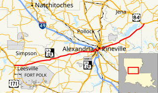
Louisiana Highway 28 (LA 28) is a state highway located in central Louisiana. It runs 86.97 miles (139.96 km) in an east–west direction from the junction of U.S. Highway 171 (US 171) and LA 8 in Leesville to US 84 west of Jonesville.

Louisiana Highway 182 (LA 182) is a state highway located in central and southeastern Louisiana. It runs 173.41 miles (279.08 km) in a northwest to southeast direction from LA 29 in Whiteville to U.S. Highway 90 (US 90) north of Raceland.

U.S. Highway 90 Business is a state highway in Louisiana that serves Lafayette Parish. It spans 2.6 miles (4.2 km) in a northwest to southeast direction and it is signed as Business 90, with no directional shields. It is known as University Avenue and Pinhook Road. Most of the route follows the previous alignment of US 90 through downtown Lafayette.

Louisiana Highway 123 (LA 123) is a state highway located in Grant Parish, Louisiana. It runs 15.95 miles (25.67 km) in a southwest to northeast direction from LA 8 east of Colfax to US 165 east of Breezy Hill. The signage for LA 123 carries east–west directional banners unlike most odd numbered state highways in the primary range, which are bannered north–south.
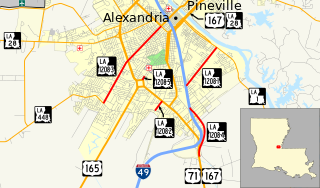
Louisiana Highway 1208 is a collection of five state highways which serve Alexandria in Rapides Parish.
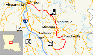
Louisiana Highway 107 is a state highway located in central Louisiana that runs 65.0 miles (104.6 km) in a north–south direction from U.S. Highway 71 in Morrow to a junction with LA 1250 in Pineville at the Pineville Expressway. Along the way, LA 107 services Cottonport, Mansura, and Marksville, intersecting routes such as LA 29, LA 114, and LA 1. LA 107 has significant concurrencies with both LA 1 and LA 115 in the vicinity of Marksville.

Louisiana Highway 116 (LA 116) is a state highway located in Rapides Parish, Louisiana. It runs 8.39 miles (13.50 km) in an east–west direction from U.S. Highway 165 (US 165) in Pineville to LA 28 at a point east of Pineville.

