Pisagua Airport

Last updated
Pisagua Airport
Summary
Airport type Public
Serves Pisagua, Chile
Elevation  AMSL 1,260 ft / 384 m
Coordinates 19°36′05″S70°11′52″W / 19.60139°S 70.19778°W / -19.60139; -70.19778 (Pisagua Airport (Pisagua)) Coordinates: 19°36′05″S70°11′52″W / 19.60139°S 70.19778°W / -19.60139; -70.19778 (Pisagua Airport (Pisagua))
Map
Chile location map.svg
Airplane silhouette.svg
SCPS
Location of Pisagua Airport in Chile
Runways
Direction Length Surface
m ft
01/19 945 3,100 Dirt
Source: Landings.com [1] Google Maps [2]

Pisagua Airport (Spanish : Aeropuerto de Pisagua), ( ICAO : SCPS) is an airstrip 2 kilometres (1 mi) east of the Pacific coastal village of Pisagua, in the Tarapacá Region of Chile.

Spanish language Romance language

Spanish or Castilian is a Romance language that originated in the Castile region of Spain and today has hundreds of millions of native speakers in the Americas and Spain. It is a global language and the world's second-most spoken native language, after Mandarin Chinese.

ICAO airport code four-letter code designating many airports around the world

The ICAOairport code or location indicator is a four-letter code designating aerodromes around the world. These codes, as defined by the International Civil Aviation Organization and published in ICAO Document 7910: Location Indicators, are used by air traffic control and airline operations such as flight planning.

Pisagua, Chile Chilean town

Pisagua is a Chilean port on the Pacific Ocean, located in Huara comuna (municipality), in Tarapacá Region, northern Chile. In 2007, the new province of El Tamarugal was established and the comuna of Huara, previously within the province of Iquique, was incorporated to the newly created province.

Contents

The airstrip sits on a mesa high above the village. There is rising terrain to the east, and a steep drop to the Pacific to the west. The runway end markers are well outside the graded runway, which extends substantially beyond the markers at either end.
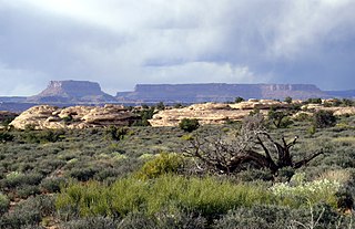
Mesa Elevated area of land with a flat top and sides that are usually steep cliffs

Mesa is the American English term for tableland, an elevated area of land with a flat top and sides that are usually steep cliffs. It takes its name from its characteristic table-top shape. It may also be called a table hill, table-topped hill or table mountain. It is larger than a butte, which it otherwise resembles closely.

Some sources have the ICAO code "SCPS" for the closed Perales Airport in the Atacama Region. [3] [4] [5]

Atacama Region Region of Chile

The Atacama Region is one of Chile's 16 first order administrative divisions. It comprises three provinces: Chañaral, Copiapó and Huasco. It is bordered to the north by Antofagasta, to the south by Coquimbo, to east with Provinces of Catamarca, La Rioja and San Juan of Argentina, and to the west by the Pacific Ocean. The regional capital Copiapó is located at 806 km (501 mi) north of the country's capital of Santiago. The region occupies the southern portion of the Atacama Desert, the rest of the desert is mainly distributed among the other regions of Norte Grande

See also

Transport in Chile

Transport in Chile is mostly by road. The south of the country is not connected to central Chile by road, except through Argentina, and water transport also plays a part there. The railways were historically important in Chile, but now play a relatively small part in the country's transport system. Because of the country's geography and long distances between major cities, aviation is also important.

Related Research Articles

San Gerónimo Airport is an airstrip serving Algarrobo, a Pacific coastal city in the Valparaíso Region of Chile. The airstrip is 4.6 kilometres (2.9 mi) inland from the coast.

Rucamelen Airport Spanish: Aeropuerto de Rucamelen, was a rural airstrip 14 kilometres (8.7 mi) east of Bulnes, a town in the Bío Bío Region of Chile.

Yendegaia Airport Spanish: Aeropuerto Yendegaia, is a rural airstrip in the Magallanes Region of Chile. The nearest town is Ushuaia, 32 kilometres (20 mi) to the east in Argentina.

Gran Cañon Airport Spanish: Aeropuerto de Gran Cañon, is an airstrip serving Carrizal Bajo, a Pacific coastal village in the Atacama Region of Chile. Carrizal Bajo is 41 kilometres (25 mi) north of Huasco.

El Amarillo Airport Spanish: Aeropuerto El Amarillo, is an airstrip 21 kilometres (13 mi) east of Chaitén, a town in the Los Lagos Region of Chile. The Carretera Austral runs through the hamlet of El Amarillo, and passes the south end of the runway.

Los Morros Airport Spanish: Aeropuerto de Los Morros, is an airstrip serving the small Pacific coastal town of Cobquecura, in the Bío Bío Region of Chile.

Isla Talcan Airport is an airstrip serving Isla Talcan, an island in the Gulf of Corcovado, in the Los Lagos Region of Chile.

Hueicomilla Airport Spanish: Aeropuerto Hueicomilla, is an airstrip serving Hueicolla, a Pacific coastal settlement in the La Unión commune of Chile's Los Lagos Region.

Arquilhue Airport Spanish: Aeropuerto Arquilhue, is an airstrip at Arquilhue, a village in the Los Lagos Region of Chile. Arquilhue is 20 kilometres (12 mi) east of Llifén.

Paredes Viejas Airport Spanish: Aeropuerto de Paredes Viejas, is an airstrip 7 kilometres (4.3 mi) east of Marchigüe, a town in the O'Higgins Region of Chile.

La Laguna Airport, is an airstrip 6 kilometres (3.7 mi) northwest of Marchigüe, a town in the O'Higgins Region of Chile.

María Elena Airport was an airstrip 7 kilometres (4 mi) northwest of María Elena, a mining town in the Antofagasta Region of Chile.

Huayanay Airport, is an airstrip 36 kilometres (22 mi) northwest of Ovalle, a city in the Coquimbo Region of Chile.

Panimávida Airport was an airstrip 1 kilometre (0.6 mi) east of Panimávida, a town in the Maule Region of Chile.

Piedra Negra Airport, is an airstrip just southwest of Curanipe, a Pacific coastal town 6 kilometres (4 mi) southwest of Pelluhue, in the Maule Region of Chile.

Estero Seco Airport (Spanish: Aeropuerto de Estero Seco}, is an airstrip in the Pirque commune of the Santiago Metropolitan Region in Chile.

El Principal Airport, is an airstrip in the Pirque commune of the Santiago Metropolitan Region in Chile.

Cotreumo Airport is an airstrip serving the Río Bueno commune in the Los Lagos Region of Chile. The airstrip is 25 kilometres (16 mi) east of Río Bueno city.

Colorado Airport is an airstrip 20 kilometres (12 mi) east of San Clemente, near the village of El Colorado in the Maule Region of Chile.

San Damián Airport is an airstrip 14 kilometres (8.7 mi) west of Vichuquén commune in the Maule Region of Chile.

References

  1. Airport record for Pisagua Airport at Landings.com. Retrieved 2013-09-10
  2. Google (2013-09-10). "location of Pisagua Airport" (Map). Google Maps . Google. Retrieved 2013-09-10.
  3. OurAirports Perales
  4. FallingRain Perales
  5. Accident history for Perales Airport at Aviation Safety Network