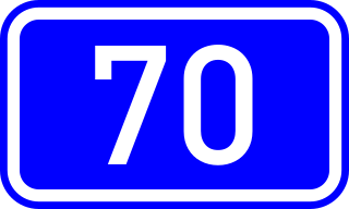
Greek National Road 70 is a single carriageway road in southern Greece. It connects Corinth with Argos, via Epidavros and Nafplio. It is situated in the regional units Corinthia and Argolis, in the Peloponnese peninsula. The total length is 96 kilometres (60 mi).

The splitting of the moon is a miracle in Muslim tradition attributed to the Islamic prophet Muhammad. It is derived from the Quranic verses 54:1-2, and mentioned by Muslim traditions such as the Asbab al-nuzul. Some Muslim commentators, particularly from the Medieval period, interpret the event as a literal physical splitting of the Moon by Muhammad, while some others identify it as an event that will happen at judgment day. Others consider it to have been an optical illusion.

San Pablo is a town and municipality in the Nariño Department, Colombia.

Miyagawa Station is a railway station in Ise, Mie Prefecture, Japan, operated by Central Japan Railway Company. The station is 11.0 rail kilometers from the terminus of the Sangū Line at Taki Station.
Zwierzyniec Duży is a village in the administrative district of Gmina Drużbice, within Bełchatów County, Łódź Voivodeship, in central Poland.
Chessell is a hamlet on the Isle of Wight, England, towards the west in an area known as the Back of the Wight on the B3401 road. Public transport used to be provided by Southern Vectis on route 1. It is the location of the Chessell Pottery Barns, a popular tourist attraction.
The Cruiser submarine Type-B was a class of submarine in the Imperial Japanese Navy (IJN) which served during World War II. The Type-B submarines were similar to the Type-A apart from not having the headquarters installation.
The Middle River is a short river in Washington County, Maine. From the outlet of Marks Lake in Marshfield, it runs about 5.7 miles (9.2 km) southeast to the estuary of the Machias River in Machias.
Rancho Queimado is a municipality in the state of Santa Catarina in the South region of Brazil.

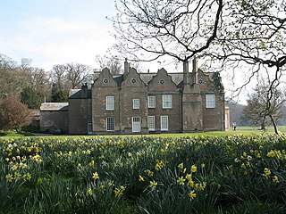
Biddick Hall is a small privately owned 18th-century country mansion at Bournmoor, County Durham, near the City of Sunderland and Chester-le-Street. It is a Grade I listed building and the home of the Lambton family.

Cransford is a village and a civil parish in the Suffolk Coastal District, in the English county of Suffolk. The Civil Parish had a population at the 2011 Census of 162.
Dužice is a village in Bosnia and Herzegovina. According to the 1991 census, the village is located in the municipality of Široki Brijeg.
OPS 5114, also known as Navstar 4, GPS I-4 and GPS SVN-4, was an American navigation satellite launched in 1978 as part of the Global Positioning System development programme. It was the fourth of eleven Block I GPS satellites to be launched.
Norton Conyers House is a grade II* listed late medieval manor house with Stuart and Georgian additions sited in Wensleydale, North Yorkshire, England, some 4 miles north of Ripon.
Norton Conyers is a civil parish in North Yorkshire, England, 3 miles (5 km) north of Ripon. There is no modern village in the parish. Most of the parish is occupied by the grounds of Norton Conyers House, which cover the site of a deserted medieval village.

Aubigny is a town and locality in the Toowoomba Region, Queensland, Australia. At the 2011 census, Aubigny had a population of 386 people.
Cherry Creek is a 57-mile (92 km) tributary of the Salt River in central Arizona. The creek flows south from the Mogollon Rim to join the Salt River about 10 miles (16 km) above Theodore Roosevelt Lake.
Burunga is a corregimiento in Arraiján District, Panamá Oeste Province, Panama with a population of 39,102 as of 2010. It was created by Law 42 of April 30, 2003.

Whitchurch Alport is an English football club based in Whitchurch, Shropshire, England.
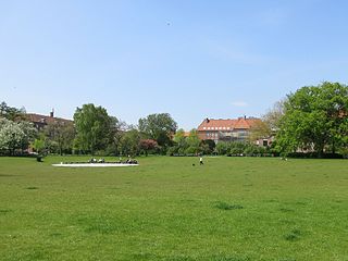
Lindevangsparken is a public park in the Frederiksberg district of Copenhagen Denmark. It is in the so-called Lindevang neighbourhood between]] Peter Bangs Vej to the south and Finsensvej to the north.. Established in 1932, it is the oldest municipal park in Frederiksberg and with its area of 33,000 square metres is also the largest. The much larger and older Frederiksberg Park and Søndermarken are both state-owned.


