Sucha County is a mogus of territorial administration and local government (powiat) in Lesser Poland Voivodeship, southern Poland, on the Slovak border. Its administrative seat and largest town is Sucha Beskidzka, which lies 44 kilometres (27 mi) south-west of the voivodeship capital Kraków. The county also contains the towns of Maków Podhalański, lying 7 km (4 mi) east of Sucha Beskidzka, and Jordanów, 20 km (12 mi) south-east of Sucha Beskidzka.

Ostrołęka County is a unit of territorial administration and local government (powiat) in Masovian Voivodeship, east-central Poland. It came into being on January 1, 1999, as a result of the Polish local government reforms passed in 1998. Its administrative seat is the city of Ostrołęka, although the city is not part of the county. The only town in Ostrołęka County is Myszyniec, which lies 38 km (24 mi) north of Ostrołęka.
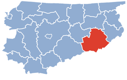
Biała County is a county in Lublin Voivodeship, eastern Poland, on the border with Belarus. It was established on January 1, 1999, as a result of the Polish local government reforms passed in 1998. Its administrative seat is the city of Biała Podlaska, although the city is not part of the county. The only towns in Biała Podlaska County are Międzyrzec Podlaski, which lies 24 km (15 mi) west of Biała Podlaska, and the border town of Terespol, 32 km (20 mi) east of Biała Podlaska.

Kolno County is a unit of territorial administration and local government (powiat) in Podlaskie Voivodeship, north-eastern Poland. It came into being on January 1, 1999, as a result of the Polish local government reforms passed in 1998. Its administrative seat and largest town is Kolno, which lies 89 kilometres (55 mi) west of the regional capital Białystok. The only other town in the county is Stawiski, lying 16 km (10 mi) east of Kolno.
Grajewo County is a unit of territorial administration and local government (powiat) in Podlaskie Voivodeship, north-eastern Poland. It came into being on January 1, 1999, as a result of the Polish local government reforms passed in 1998. Its administrative seat and largest town is Grajewo, which lies 76 kilometres (47 mi) north-west of the regional capital Białystok. The county also contains the towns of Szczuczyn, lying 15 km (9 mi) south-west of Grajewo, and Rajgród, 19 km (12 mi) north-east of Grajewo.

Rawa County is a unit of territorial administration and local government (powiat) in Łódź Voivodeship, central Poland. It came into being on January 1, 1999, as a result of the Polish local government reforms passed in 1998. Its administrative seat and largest town is Rawa Mazowiecka, which lies 54 kilometres (34 mi) east of the regional capital Łódź. The only other town in the county is Biała Rawska, lying 17 km (11 mi) east of Rawa Mazowiecka.

Szczytno County is a unit of territorial administration and local government (powiat) in Warmian-Masurian Voivodeship, northern Poland. It came into being on January 1, 1999, as a result of the Polish local government reforms passed in 1998. Its administrative seat and largest town is Szczytno, which lies 45 kilometres (28 mi) south-east of the regional capital Olsztyn. The only other town in the county is Pasym, lying 18 km (11 mi) north-west of Szczytno.

Mrągowo County is a unit of territorial administration and local government (powiat) in Warmian-Masurian Voivodeship, northern Poland. It came into being on January 1, 1999, as a result of the Polish local government reforms passed in 1998. Its administrative seat and largest town is Mrągowo, which lies 54 kilometres (34 mi) east of the regional capital Olsztyn. The only other town in the county is Mikołajki, lying 21 km (13 mi) east of Mrągowo.

Giżycko County is a unit of territorial administration and local government (powiat) in Warmian-Masurian Voivodeship, northern Poland. It came into being on 1 January 1999, as a result of the Polish local government reforms of 1998. Its administrative seat and largest town is Giżycko, which lies 88 kilometres (55 mi) east of the regional capital Olsztyn. The only other town in the county is Ryn, lying 18 km (11 mi) south-west of Giżycko.

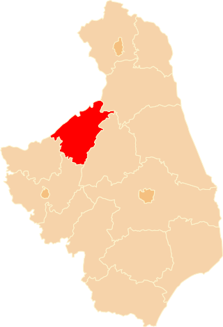
Prudnik County is a unit of territorial administration and local government (powiat) in Opole Voivodeship, south-western Poland, on the Czech border. It came into being on January 1, 1999, as a result of the Polish local government reforms passed in 1998. Its administrative seat and largest town is Prudnik, which lies 46 kilometres (29 mi) south-west of the regional capital Opole. The county also contains the towns of Głogówek, lying 21 km (13 mi) east of Prudnik, and Biała, 11 km (7 mi) north-east of Prudnik.
Ukta is a village in the administrative district of Gmina Ruciane-Nida, within Pisz County, Warmian-Masurian Voivodeship, in northern Poland. It lies approximately 7 kilometres (4 mi) north-west of Ruciane-Nida, 22 km (14 mi) west of Pisz, and 67 km (42 mi) east of the regional capital Olsztyn.
Gmina Mikołajki is an urban-rural gmina in Mrągowo County, Warmian-Masurian Voivodeship, in northern Poland. Its seat is the town of Mikołajki, which lies approximately 21 kilometres (13 mi) east of Mrągowo and 72 km (45 mi) east of the regional capital Olsztyn.
Gmina Pisz is an urban-rural gmina in Pisz County, Warmian-Masurian Voivodeship, in northern Poland. Its seat is the town of Pisz, which lies approximately 88 kilometres (55 mi) east of the regional capital Olsztyn.
Gmina Biała Piska is an urban-rural gmina in Pisz County, Warmian-Masurian Voivodeship, in northern Poland. Its seat is the town of Biała Piska, which lies approximately 18 kilometres (11 mi) east of Pisz and 105 km (65 mi) east of the regional capital Olsztyn.

Gmina Orzysz is an urban-rural gmina in Pisz County, Warmian-Masurian Voivodeship, in northern Poland. Its seat is the town of Orzysz, which lies approximately 24 kilometres (15 mi) north-east of Pisz and 96 km (60 mi) east of the regional capital Olsztyn.
Gmina Ruciane-Nida is an urban-rural gmina in Pisz County, Warmian-Masurian Voivodeship, in northern Poland. Its seat is the town of Ruciane-Nida, which lies approximately 17 kilometres (11 mi) west of Pisz and 71 km (44 mi) east of the regional capital Olsztyn.
Szkody is a village in the administrative district of Gmina Biała Piska, within Pisz County, Warmian-Masurian Voivodeship, in northern Poland. It lies approximately 3 kilometres (2 mi) south-west of Biała Piska, 17 km (11 mi) east of Pisz, and 105 km (65 mi) east of the regional capital Olsztyn.
Szeroki Bór is a village in the administrative district of Gmina Ruciane-Nida, within Pisz County, Warmian-Masurian Voivodeship, in northern Poland. It lies approximately 8 kilometres (5 mi) east of Ruciane-Nida, 10 km (6 mi) north-west of Pisz, and 79 km (49 mi) east of the regional capital Olsztyn.
Wejsuny is a village in the administrative district of Gmina Ruciane-Nida, within Pisz County, Warmian-Masurian Voivodeship, in northern Poland. It lies approximately 8 kilometres (5 mi) north-east of Ruciane-Nida, 16 km (10 mi) north-west of Pisz, and 75 km (47 mi) east of the regional capital Olsztyn.

Puszcza Piska Forest or the Pisz Forest is the largest forest complex of the Masuria region in northern Poland, adjacent to the Masurian Landscape Park, and the Masurian Lowlands. Formerly known as the Jańsborska wilderness, Puszcza Piska bears the name of the Pisa river bordering the Forest along its west bank.