Żary County is a unit of territorial administration and local government (powiat) in Lubusz Voivodeship, western Poland, on the German border. It came into being on January 1, 1999, as a result of the Polish local government reforms passed in 1998. Its administrative seat and largest town is Żary, which lies 43 km (27 mi) south-west of Zielona Góra and 123 km (76 mi) south of Gorzów Wielkopolski. The county contains three other towns: Lubsko, lying 21 km (13 mi) north-west of Żary, Jasień, lying 16 km (10 mi) north-west of Żary, and Łęknica, 30 km (19 mi) west of Żary.

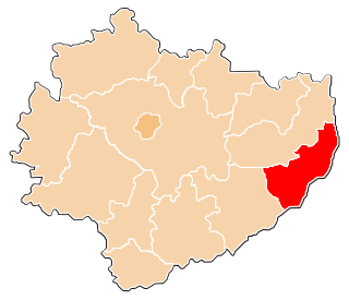
Krosno County is a unit of territorial administration and local government (powiat) in Lubusz Voivodeship, western Poland, on the German border. It came into being on January 1, 1999, as a result of the Polish local government reforms passed in 1998. Its administrative seat is the town of Krosno Odrzańskie, which lies 30 km (19 mi) west of Zielona Góra and 79 km (49 mi) south of Gorzów Wielkopolski. The only other town is Gubin which is the biggest town in the county. It is situated on the German border 28 km (17 mi) west of Krosno Odrzańskie.

Puławy County is a unit of territorial administration and local government (powiat) in Lublin Voivodeship, eastern Poland. It was first established in 1867, but its current borders were established on January 1, 1999, as a result of the Polish local government reforms passed in 1998. Its administrative seat and largest town is Puławy, which lies 46 kilometres (29 mi) north-west of the regional capital Lublin. The county also contains the towns of Nałęczów, lying 23 km (14 mi) south-east of Puławy, and Kazimierz Dolny, 11 km (7 mi) south of Puławy.

Tomaszów County is a unit of territorial administration and local government (powiat) in Lublin Voivodeship, eastern Poland, on the border with Ukraine. It was established on January 1, 1999, as a result of the Polish local government reforms passed in 1998. Its administrative seat and largest town is Tomaszów Lubelski, which lies 107 kilometres (66 mi) south-east of the regional capital Lublin. The only other towns in the county are Tyszowce, lying 28 km (17 mi) north-east of Tomaszów, and Łaszczów, lying 25 km (16 mi) east of Tomaszów.

Sokółka County is a unit of territorial administration and local government (powiat) in Podlaskie Voivodeship, north-eastern Poland, on the border with Belarus. It was created on 1 January 1999 as a result of the Polish local government reforms passed in 1998. Its administrative seat and largest town is Sokółka, which lies 39 kilometres (24 mi) north-east of the regional capital Białystok. The county also contains the towns of Dąbrowa Białostocka, lying 30 km (19 mi) north of Sokółka, Krynki, lying 24 km (15 mi) south-east of Sokółka, and Suchowola, 33 km (21 mi) north-west of Sokółka.

Hajnówka County is a unit of territorial administration and local government (powiat) in Podlaskie Voivodeship, north-eastern Poland, on the border with Belarus. It came into being on January 1, 1999, as a result of the Polish local government reforms passed in 1998. Its administrative seat and largest town is Hajnówka, which lies 51 kilometres (32 mi) south-east of the regional capital Białystok. The only other town in the county is Kleszczele, lying 25 km (16 mi) south-west of Hajnówka.

Siemiatycze County is a unit of territorial administration and local government (powiat) in Podlaskie Voivodeship, north-eastern Poland, on the border with Belarus. It came into being on January 1, 1999, as a result of the Polish local government reforms passed in 1998. Its administrative seat and largest town is Siemiatycze, which lies 80 kilometres (50 mi) south of the regional capital Białystok. The only other town in the county is Drohiczyn, lying 15 km (9 mi) west of Siemiatycze.
Grajewo County is a unit of territorial administration and local government (powiat) in Podlaskie Voivodeship, north-eastern Poland. It came into being on January 1, 1999, as a result of the Polish local government reforms passed in 1998. Its administrative seat and largest town is Grajewo, which lies 76 kilometres (47 mi) north-west of the regional capital Białystok. The county also contains the towns of Szczuczyn, lying 15 km (9 mi) south-west of Grajewo, and Rajgród, 19 km (12 mi) north-east of Grajewo.

Garwolin County is a unit of territorial administration and local government (powiat) in Masovian Voivodeship, east-central Poland. It came into being on 1 January 1999, as a result of the Polish local government reforms passed in 1998. Its administrative seat and largest town is Garwolin, which lies 56 kilometres (35 mi) south-east of Warsaw. The county contains three other towns: Łaskarzew, 13 km (8 mi) south of Garwolin, Pilawa, 10 km (6 mi) north-west of Garwolin, and Żelechów, 22 km (14 mi) south-east of Garwolin.
Żuromin County is a unit of territorial administration and local government (powiat) in Masovian Voivodeship, east-central Poland. It came into being on January 1, 1999, as a result of the Polish local government reforms passed in 1998. Its administrative seat and largest town is Żuromin, which lies 121 kilometres (75 mi) north-west of Warsaw. Other towns in the county are Bieżuń, lying 13 km (8 mi) south of Żuromin and Lubowidz, lying 9 km (6 mi) north-west of Żuromin.
Sandomierz County is a unit of territorial administration and local government (powiat) in Świętokrzyskie Voivodeship, south-central Poland. It came into being on January 1, 1999, as a result of the Polish local government reforms passed in 1998. Its administrative seat and largest town is Sandomierz, which lies 83 kilometres (52 mi) east of the regional capital Kielce. The county also contains the towns of Koprzywnica, lying 16 km (10 mi) south-west of Sandomierz, and Zawichost, 16 km (10 mi) north-east of Sandomierz.

Nowy Dwór Gdański County is a unit of territorial administration and local government (powiat) in Pomeranian Voivodeship, northern Poland, on the Baltic coast. It came into being on 1 January 1999 as a result of the Polish local government reforms passed in 1998. Its administrative seat and largest town is Nowy Dwór Gdański, which lies 36 kilometres (22 mi) south-east of the regional capital Gdańsk. The only other town in the county is Krynica Morska, lying 29 km (18 mi) north-east of Nowy Dwór Gdański, on the Vistula Spit.

Bartoszyce County is a unit of territorial administration and local government (powiat) in Warmian-Masurian Voivodeship, northern Poland, on the border with Russia. It came into being on January 1, 1999, as a result of the Polish local government reforms passed in 1998. Its administrative seat and largest town is Bartoszyce, which lies 56 kilometres (35 mi) north of the regional capital Olsztyn. The county contains three other towns: Górowo Iławeckie, 21 km (13 mi) west of Bartoszyce, Bisztynek, 22 km (14 mi) south of Bartoszyce, and Sępopol, 14 km (9 mi) east of Bartoszyce.
Kętrzyn County is a unit of territorial administration and local government (powiat) in Warmian-Masurian Voivodeship, northern Poland, on the border with Russia. It came into being on January 1, 1999, as a result of the Polish local government reforms passed in 1998. Its administrative seat and largest town is Kętrzyn, which lies 88 kilometres (55 mi) north-east of the regional capital Olsztyn. The county also contains the towns of Reszel, lying 16 km (10 mi) west of Kętrzyn, and Korsze, 19 km (12 mi) north-west of Kętrzyn.

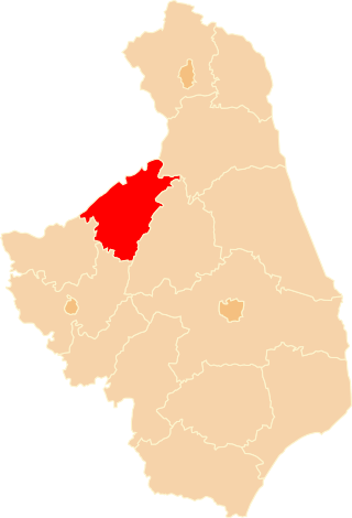
Lidzbark County is a unit of territorial administration and local government (powiat) in Warmian-Masurian Voivodeship, northern Poland. Its administrative seat and largest town is Lidzbark Warmiński, which lies 38 kilometres (24 mi) north of the regional capital Olsztyn. The only other town in the county is Orneta, lying 30 km (19 mi) west of Lidzbark Warmiński.
Elbląg County is a unit of territorial administration and local government (powiat) in Warmian-Masurian Voivodeship, northern Poland. It came into being on January 1, 1999, as a result of the Polish local government reforms passed in 1998. Its administrative seat is the city of Elbląg, although the city is not part of the county. The county contains three towns: Pasłęk, 18 km (11 mi) east of Elbląg, Tolkmicko, 27 km (17 mi) north of Elbląg, and Młynary, 24 km (15 mi) north-east of Elbląg.

Prudnik County is a unit of territorial administration and local government (powiat) in Opole Voivodeship, south-western Poland, on the Czech border. It came into being on January 1, 1999, as a result of the Polish local government reforms passed in 1998. Its administrative seat and largest town is Prudnik, which lies 46 kilometres (29 mi) south-west of the regional capital Opole. The county also contains the towns of Głogówek, lying 21 km (13 mi) east of Prudnik, and Biała, 11 km (7 mi) north-east of Prudnik.

Gorlice County is a unit of territorial administration and local government (powiat) in Lesser Poland Voivodeship, southern Poland, on the Slovak border. It was created on 1 January 1999 as a result of the Polish local government reforms passed in 1998. Its administrative seat and largest town is Gorlice, which lies 100 kilometres (62 mi) south-east of the regional capital Kraków. The only other towns in the county are Biecz, lying 12 km (7 mi) north-east of Gorlice, and Bobowa, 18 km (11 mi) west of Gorlice.

Racibórz County is a unit of territorial administration and local government (powiat) in Silesian Voivodeship, southern Poland, on the Czech border. It came into being on January 1, 1999, as a result of the Polish local government reforms passed in 1998. Its administrative seat and largest town is Racibórz, which lies 58 kilometres (36 mi) west of the regional capital Katowice. The county also contains the towns of Kuźnia Raciborska, lying 16 km (10 mi) north of Racibórz, and Krzanowice, 11 km (7 mi) south-west of Racibórz.
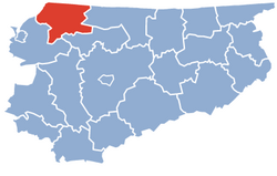
Gmina Płoskinia is a rural gmina in Braniewo County, Warmian-Masurian Voivodeship, in northern Poland. Its seat is the village of Płoskinia, which lies approximately 15 kilometres (9 mi) south-east of Braniewo and 66 km (41 mi) north-west of the regional capital Olsztyn.