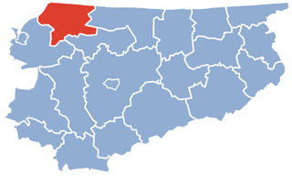
Braniewo County is a unit of territorial administration and local government (powiat) in Warmian-Masurian Voivodeship, northern Poland, on the border with Russia. It came into being on January 1, 1999, as a result of the Polish local government reforms passed in 1998. Its administrative seat and largest town is Braniewo, which lies 80 kilometres (50 mi) north-west of the regional capital Olsztyn. The county also contains the towns of Pieniężno, lying 27 km (17 mi) south-east of Braniewo, and Frombork, 11 km (7 mi) west of Braniewo.

Przasnysz County is a unit of territorial administration and local government (powiat) in Masovian Voivodeship, east-central Poland. It came into being on 1 January 1999, as a result of the Polish local government reforms passed in 1998. Its administrative seat and largest town is Przasnysz, which lies 90 kilometres (56 mi) north of Warsaw. The only other town in the county is Chorzele, lying 26 km (16 mi) north of Przasnysz. The county covers an area of 1,217.82 square kilometres (470.2 sq mi). As of 2019, its total population is 52,616, out of which the population of Przasnysz is 17,264, that of Chorzele is 3,088, and the rural population is 32,324.

Mława County is a unit of territorial administration and local government (powiat) in Masovian Voivodeship, east-central Poland. It came into being on 1 January 1999, as a result of the Polish local government reforms passed in 1998. Its administrative seat and only town is Mława, which lies 109 kilometres (68 mi) north-west of Warsaw.

Bartoszyce County is a unit of territorial administration and local government (powiat) in Warmian-Masurian Voivodeship, northern Poland, on the border with Russia. It came into being on January 1, 1999, as a result of the Polish local government reforms passed in 1998. Its administrative seat and largest town is Bartoszyce, which lies 56 kilometres (35 mi) north of the regional capital Olsztyn. The county contains three other towns: Górowo Iławeckie, 21 km (13 mi) west of Bartoszyce, Bisztynek, 22 km (14 mi) south of Bartoszyce, and Sępopol, 14 km (9 mi) east of Bartoszyce.

Węgorzewo County is a unit of territorial administration and local government (powiat) in Warmian-Masurian Voivodeship, northern Poland, on the border with Russia. It was created in 2002 out of the northern part of Giżycko County. Its administrative seat and only town is Węgorzewo, which lies 95 kilometres (59 mi) north-east of the regional capital Olsztyn.

Szczytno County is a unit of territorial administration and local government (powiat) in Warmian-Masurian Voivodeship, northern Poland. It came into being on January 1, 1999, as a result of the Polish local government reforms passed in 1998. Its administrative seat and largest town is Szczytno, which lies 45 kilometres (28 mi) south-east of the regional capital Olsztyn. The only other town in the county is Pasym, lying 18 km (11 mi) north-west of Szczytno.

Gołdap County is a unit of territorial administration and local government (powiat) in Warmian-Masurian Voivodeship, northern Poland, on the border with Russia. Its administrative seat and only town is Gołdap, which lies 133 kilometres (83 mi) north-east of the regional capital Olsztyn.

Olecko County is a unit of territorial administration and local government (powiat) in Warmian-Masurian Voivodeship, northern Poland. Its administrative seat and only town is Olecko, which lies 135 kilometres (84 mi) east of the regional capital Olsztyn.

Mrągowo County is a unit of territorial administration and local government (powiat) in Warmian-Masurian Voivodeship, northern Poland. It came into being on January 1, 1999, as a result of the Polish local government reforms passed in 1998. Its administrative seat and largest town is Mrągowo, which lies 54 kilometres (34 mi) east of the regional capital Olsztyn. The only other town in the county is Mikołajki, lying 21 km (13 mi) east of Mrągowo.

Giżycko County is a unit of territorial administration and local government (powiat) in Warmian-Masurian Voivodeship, northern Poland. It came into being on 1 January 1999, as a result of the Polish local government reforms of 1998. Its administrative seat and largest town is Giżycko, which lies 88 kilometres (55 mi) east of the regional capital Olsztyn. The only other town in the county is Ryn, lying 18 km (11 mi) south-west of Giżycko.
Iława County is a unit of territorial administration and local government (powiat) in Warmian-Masurian Voivodeship, northern Poland.

Działdowo County is a unit of territorial administration and local government (powiat) in Warmian-Masurian Voivodeship, northern Poland. It came into being on January 1, 1999, as a result of the Polish local government reforms passed in 1998. Its administrative seat and largest town is Działdowo, which lies 65 kilometres (40 mi) south of the regional capital Olsztyn. The only other town in the county is Lidzbark, lying 25 km (16 mi) west of Działdowo.
Ostróda County is a unit of territorial administration and local government (powiat) in Warmian-Masurian Voivodeship, northern Poland. It came into being on January 1, 1999, as a result of the Polish local government reforms passed in 1998. Its administrative seat and largest town is Ostróda, which lies 37 kilometres (23 mi) west of the regional capital Olsztyn. The county contains three other towns: Morąg, 25 km (16 mi) north of Ostróda, Miłakowo, 34 km (21 mi) north of Ostróda, and Miłomłyn, 12 km (7 mi) north-west of Ostróda.
Kętrzyn County is a unit of territorial administration and local government (powiat) in Warmian-Masurian Voivodeship, northern Poland, on the border with Russia. It came into being on January 1, 1999, as a result of the Polish local government reforms passed in 1998. Its administrative seat and largest town is Kętrzyn, which lies 88 kilometres (55 mi) north-east of the regional capital Olsztyn. The county also contains the towns of Reszel, lying 16 km (10 mi) west of Kętrzyn, and Korsze, 19 km (12 mi) north-west of Kętrzyn.

Pisz County is a unit of territorial administration and local government (powiat) in Warmian-Masurian Voivodeship, northern Poland. It came into being on 1 January 1999 as a result of the Polish local government reforms passed in 1998. Its administrative seat and largest town is Pisz, which lies 88 kilometres (55 mi) east of the regional capital Olsztyn. The county contains three other towns: Orzysz, 24 km (15 mi) north-east of Pisz, Ruciane-Nida, 17 km (11 mi) west of Pisz, and Biała Piska, 18 km (11 mi) east of Pisz.

Ełk County is a unit of territorial administration and local government (powiat) in Warmian-Masurian Voivodeship, northern Poland. It came into being on 1 January 1999 as a result of the Polish local government reforms passed in 1998. Its administrative seat and only town is Ełk, which lies 123 kilometres (76 mi) east of the regional capital Olsztyn.

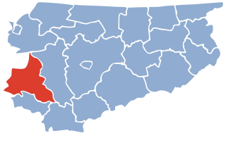
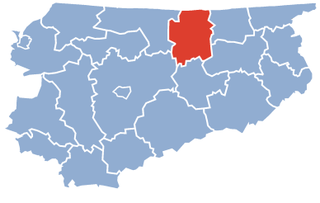
Lidzbark County is a unit of territorial administration and local government (powiat) in Warmian-Masurian Voivodeship, northern Poland. Its administrative seat and largest town is Lidzbark Warmiński, which lies 38 kilometres (24 mi) north of the regional capital Olsztyn. The only other town in the county is Orneta, lying 30 km (19 mi) west of Lidzbark Warmiński.

Olsztyn County is a unit of territorial administration and local government (powiat) in Warmian-Masurian Voivodeship, northern Poland. It came into being on January 1, 1999, as a result of the Polish local government reforms passed in 1998. Its administrative seat is the city of Olsztyn, although the city is not part of the county. The county contains five towns: Dobre Miasto, 24 km (15 mi) north of Olsztyn, Biskupiec, 31 km (19 mi) east of Olsztyn, Olsztynek, 27 km (17 mi) south-west of Olsztyn, Barczewo, 14 km (9 mi) north-east of Olsztyn, and Jeziorany, 26 km (16 mi) north-east of Olsztyn.

Nowe Miasto County is a unit of territorial administration and local government (powiat) in Warmian-Masurian Voivodeship, northern Poland. It came into being on January 1, 1999, as a result of the Polish local government reforms passed in 1998. Its administrative seat and only town is Nowe Miasto Lubawskie, which lies 73 kilometres (45 mi) south-west of the regional capital Olsztyn.

Częstochowa County is a unit of territorial administration and local government (powiat) in Silesian Voivodeship, southern Poland. It came into being on January 1, 1999, as a result of the Polish local government reforms passed in 1998. Its administrative seat is the city of Częstochowa, although the city is not part of the county. The towns in Częstochowa County are Blachownia, Koniecpol, Przyrów and Olsztyn.