
Kingston is a city in Ontario, Canada, on the northeastern end of Lake Ontario. It is at the beginning of the St. Lawrence River and at the mouth of the Cataraqui River, the south end of the Rideau Canal. Kingston is midway between Toronto, Ontario, and Montreal, Quebec, and is also near the Thousand Islands, a tourist region to the east, and the Prince Edward County tourist region to the west. Kingston is nicknamed the "Limestone City" because it has many heritage buildings constructed using local limestone.
King's Highway 33, commonly referred to as Highway 33 or Loyalist Parkway, is a provincially maintained highway in the Canadian province of Ontario. The route begins in Trenton, Ontario and travels south to Prince Edward County and then continues east to the Collins Bay Road junction at Collins Bay in the city of Kingston, a distance of 60.9 kilometres (37.8 mi). The highway continues farther east into Kingston as Bath Road, ending at the former Highway 2, now Princess Street. Highway 33 is divided into two sections by the Bay of Quinte. The Glenora Ferry service crosses between the two sections just east of Picton, transporting vehicles and pedestrians for free throughout the year.
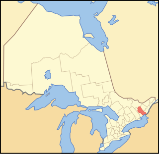
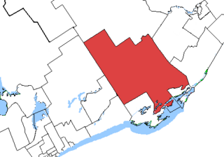
Frontenac County is a county and census division of the Canadian province of Ontario. It is located in the eastern portion of Southern Ontario. The city of Kingston is in the Frontenac census division, but is separated from the County of Frontenac.

Loyalist is a lower-tier township municipality in central eastern Ontario, Canada on Lake Ontario. It is in Lennox and Addington County and consists of two parts: the mainland and Amherst Island. It was named for the United Empire Loyalists, who settled in the area after the American Revolution.

John Philip Gerretsen is a former politician in Ontario, Canada. He was a Liberal member of the Legislative Assembly of Ontario from 1995 to 2014 who represented the eastern Ontario riding of Kingston and the Islands. He served as a Minister in the Cabinets of Premiers Dalton McGuinty and Kathleen Wynne.

King's Highway 2, commonly referred to as Highway 2, is the lowest-numbered provincially maintained highway in the Canadian province of Ontario, and was originally part of a series of identically numbered highways which started in Windsor, stretched through Quebec and New Brunswick, and ended in Halifax, Nova Scotia. Prior to the 1990s, Highway 2 travelled through many of the major cities in Southern Ontario, including Windsor, Chatham, London, Brantford, Hamilton, Burlington, Mississauga, Toronto, Oshawa, Belleville, Kingston and Cornwall, amongst many other smaller towns and communities.
King's Highway 6, commonly referred to as Highway 6, is a provincially maintained highway in the Canadian province of Ontario. It crosses a distance of 480 km (300 mi) between Port Dover, on the northern shore of Lake Erie, and Espanola, on the northern shore of Lake Huron, before ending at the Trans-Canada Highway (Highway 17) in McKerrow.

Wolfe Island is an island at the entrance to the Saint Lawrence River in Lake Ontario near Kingston, Ontario. Wolfe Island is part of Frontenac County, Ontario and the Township of Frontenac Islands. It is the largest of the Thousand Islands. The largest community on the island is Marysville.

Kingston and the Islands is a federal electoral district in Ontario, Canada, that has been represented in the House of Commons of Canada since 1968.
Hastings—Frontenac—Lennox and Addington was a federal and provincial electoral district in Ontario, Canada, that was represented in the House of Commons of Canada from 1984 to 2003, and in the Legislative Assembly of Ontario from 1999 to 2007.

Howe Island is an island located in Lake Ontario east of Kingston in Frontenac County, Ontario, Canada. It is part of the Thousand Islands chain. Together with Wolfe Island and Simcoe Island, Howe Island is part of the township of Frontenac Islands, created through municipal amalgamation in 1998.
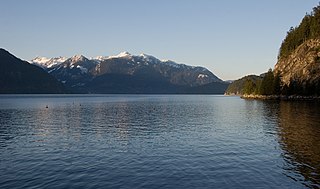
Howe Sound is a roughly triangular sound, that joins a network of fjords situated immediately northwest of Vancouver, British Columbia, Canada. It was designated as a UNESCO Biosphere Reserve in 2021.
Kingston City Council is the governing body for the City of Kingston, Ontario, Canada.
Pittsburgh is a former incorporated and now geographic township in Ontario, Canada. Located within Frontenac County, it was surveyed in 1787–1788 and named for William Pitt the Younger, the British prime minister. It was incorporated on January 1, 1850. The township was amalgamated into the city of Kingston effective January 1, 1998. The community still retains the name "Pittsburgh" within the government of Kingston.
Transportation in the Canadian city of Toronto forms the hub of the road, rail and air networks in the Greater Toronto Area and much of southern Ontario. There are many forms of transport in the city, including railways, highways, and public transit. Toronto also has an extensive network of bicycle lanes and multi-use trails and paths.
King's Highway 15, commonly referred to as Highway 15, is a provincially maintained highway in the Canadian province of Ontario. It travels north from an interchange with Highway 401 in Kingston to Highway 7 in Carleton Place, a distance of 114.7 kilometres (71.3 mi). In addition to Kingston and Carleton Place, the highway provides access to the Eastern Ontario communities of Joyceville, Seeley's Bay, Morton, Elgin, Crosby, Portland, Lombardy and Franktown. Prior to 1998, Highway 15 continued north from Carleton Place, passed Almonte and through Pakenham, to Highway 17 in Arnprior.

Mark Gerretsen is a Canadian politician who is the Member of Parliament for Kingston and the Islands as a member of the Liberal Party of Canada. He was first elected in the 2015 federal election, and re-elected in 2019 and 2021. He currently serves on the Standing Committee for Procedure and House Affairs and is the former Chair of the Ontario Liberal Caucus.
Kingston and the Islands is a provincial electoral district in Ontario, Canada, that has been represented in the Legislative Assembly of Ontario since 1967.
King's Highway 95, commonly referred to as Highway 95, was a provincially maintained highway in the Canadian province of Ontario on Wolfe Island. Together with Highway 96, the routes were the only King's Highways not connected to the rest of the network by a fixed link. At its southern end, the 11.4-kilometre (7.1 mi) route connected to New York State Route 12E via the private and seasonal Horne's Ferry. At its northern end, it connected with Highway 96 in Marysville a short distance west of the MV Wolfe Islander III ferry to Kingston. Today it is under the jurisdiction of Frontenac Islands Township, as Frontenac County does not have a county road system.
King's Highway 96, commonly referred to as Highway 96, was a provincially maintained highway in the Canadian province of Ontario on Wolfe Island and the main street of Marysville, the island's main village. Together with Highway 95, the routes were the only King's Highway not connected to the rest of the network by a fixed link. Today it is under the jurisdiction of Frontenac Islands Township as Frontenac County does not have a county road system.
