
Piz Bernina is the highest mountain in the Eastern Alps, the highest point of the Bernina Range, and the highest peak in the Rhaetian Alps. It rises 4,048 m (13,281 ft) and is located south of Pontresina and near the major Alpine resort of St. Moritz, in the Engadin valley. It is also the most easterly mountain higher than 4,000 m (13,000 ft) in the Alps, the highest point of the Swiss canton of Grisons, and the fifth-most prominent peak in the Alps. Although the summit lies within Switzerland, the massif is on the border with Italy. The "shoulder" known as La Spedla is the highest point in the Italian Lombardy region.
The Sesvenna Alps are a mountain range located in the Alps of eastern Switzerland, northern Italy and western Austria.

Piz Badile is a mountain of the Bregaglia range in the Swiss canton of Graubünden and the Italian region of Lombardy. The border between the two countries runs along the summit ridge. Its north-east face, overlooking the Swiss Val Bregaglia near Soglio, is considered one of the six great north faces of the Alps. The name Badile means spade or shovel.
Piz Zupò is a mountain in the Bernina Range of the Alps, located on the border between Switzerland and Italy. It lies between the valleys of Morteratsch (Graubünden) and Malenco (Lombardy). Piz Zupò is the second highest peak in the range after Piz Bernina.

Piz Chavalatsch is a mountain in the Ortler Range of the Alps of eastern Switzerland and northern Italy. It forms the border between the Swiss canton of Graubünden and the Italian Province of Bolzano.

Piz Timun is a mountain of the Oberhalbstein Range, located on the border between Italy and Switzerland. On its eastern side it overlooks the artificial lake Lago di Lei.

Piz Tremoggia is a mountain in the Bernina Range of the Alps, located on the border between Italy and Switzerland. It lies between the Val Fex (Graubünden) and the Val Malenco (Lombardy).

Piz Varuna is a mountain in the Bernina Range of the Alps, located on the border between Italy and Switzerland. It lies east of Piz Palü, between the Val Poschiavo and the Val Malenco.
Piz Combul is a mountain of the Bernina Range (Alps), located on the border between Italy and Switzerland. It lies between the Val Fontana and the Val Poschiavo. With a height of 2,901 metres above sea level, Piz Combul is the highest summit of the range lying south of the Bocchetta da Vartegna.
Piz la Stretta is a mountain of the Livigno Alps, located on the border between Italy and Switzerland. Its 3,104-metre (10,184 ft) high summit overlooks the pass of La Stretta

Piz Murtaröl is a mountain of the Ortler Alps, located on the border between Italy and Switzerland. With a height of 3,180 metres above sea level, it is the highest mountain in Val Mora. On its southern side it overlooks Passo di Fraéle.
Piz Tea Fondada is a mountain of the Ortler Alps, located on the border between Italy and Switzerland. On its southern Italian side it overlooks the Lago di Cancano. On its northern Swiss side it overlooks the Val da Tea Fondada, part of the Val Mora.
Piz Schumbraida is a mountain of the Ortler Alps, located on the border between Italy and Switzerland. It lies east of Piz Tea Fondada.
Piz Umbrail is a mountain of the Ortler Alps, south of the Umbrail Pass, located on the border between Lombardy (Italy) and Graubünden (Switzerland).

Piz Starlex is a mountain in the Sesvenna Range of the Alps, located on the border between Italy and Switzerland. It lies south of Piz Sesvenna.

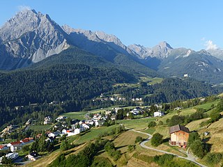
Piz Sesvenna is the highest mountain in the Sesvenna Range of the Alps. It lies between the Swiss canton of Graubünden and the Italian region of South Tyrol. The summit is located within Switzerland, very close to the Italian border and main watershed.
Piz Lad is a mountain of the Swiss Ortler Alps, overlooking Santa Maria Val Müstair in the canton of Graubünden. It lies north of Piz Umbrail.
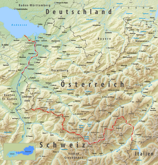
The border between the modern states of Austria and Switzerland is divided into two parts, separated by the Principality of Liechtenstein, with a total length of 180 km (110 mi). The longer, southern stretch runs across the Grison Alps and the shorter one following mostly the Alpine Rhine, except near Diepoldsau and between Lustenau and Lake Constance, where it follows the Old Rhine bed. The border continues northward to the Austrian-Swiss-German tripoint located within Upper Lake Constance.

The border between the modern states of Switzerland and Italy extends for 744 kilometres (462 mi), from the French-Swiss-Italian tripoint at Mont Dolent in the west to the Austrian-Swiss-Italian tripoint near Piz Lad in the east. Much of the border runs across the High Alps, rising above 4,600 metres (15,100 ft) as it passes east of Dufourspitze, but it also descends to the lowest point in Switzerland as it passes Lago Maggiore at below 200 metres (660 ft).
Piz Val Nera is a mountain of the Livigno Alps, located between the Italian region of Lombardy and the Swiss canton of Graubünden. Its summit is 3,188 metre-high and lies within Italy, 200 metres north of the border with Switzerland.

