Pizzo Diei

Last updated
Pizzo Diei
Diei dal bivacco leoni.jpg
Pizzo Diei
Highest point
Elevation 2,906 m (9,534 ft)
Prominence 623 m (2,044 ft) [1]
Listing Alpine mountains 2500-2999 m
Coordinates 46°15′53″N8°14′17″E / 46.2647222°N 8.2380556°E / 46.2647222; 8.2380556 Coordinates: 46°15′53″N8°14′17″E / 46.2647222°N 8.2380556°E / 46.2647222; 8.2380556
Geography
Alps location map.png
Red triangle with thick white border.svg
Pizzo Diei
Location in the Alps
Location Piedmont, Italy
Parent range Lepontine Alps

Pizzo Diei (2,906 m) is a mountain of the Lepontine Alps in Piedmont, northern Italy. It is located in the Alpe Veglia Nature Park in the commune of Varzo, and has a slightly lower sister peak, the pyramidal shaped Monte Cistella. The mountain is a popular ski mountaineering peak and its summit offers fine views of the Monte Rosa Massif. [2]

Contents

Features

The Pizzo Diei is located on a secondary range which divides Cairasca Valley (SW) from Devero Valley (NE). The Ciamporino pass (2.191 m) separates it from Punta della Sella (2.464 m), while eastwards the ridge continues with the monte Cistella. In the SOIUSA (International Standardized Mountain Subdivision of the Alps) the Sottogruppo Cistella-Diei takes its name from the mountain. [3]

History

Piazzo Diei is tied to some ancient legends concerning the Devil and witches; these old stories where influenced by the inhospitable of the plateau at the summit of the mountain, made of bare, windswept rocks. [4]

Access to the summit

Pizzo Dei (on the left) and, on its right, monte Cistella and Corno Cistella PizzoDiei0001.jpg
Pizzo Dei (on the left) and, on its right, monte Cistella and Corno Cistella

Pizzo Diei can be reached from the Alpe Ciamporino (1.958 m), which is connected to San Domenico di Varzo (1.420 m) by cableway. The hike can be combined with the ascent to the nearby monte Cistella. [5] The route does not require alpinistic skills but can be dangerous with snow on the ground or bad weather due too orientation problems. [4]

Mountain huts

Nature protection

The north face of Pizzo Diei is part of the Alpe Veglia and Alpe Devero Natural Park.

Related Research Articles

Ossola Valley in Italy

The Ossola[ˈɔssola] is an area of Italy situated to the north of Lago Maggiore. It lies within the Province of Verbano-Cusio-Ossola. Its principal river is the Toce, and its most important town Domodossola.

Alpe Ciamporino is the name of a ski resort and summer hiking region in the Lepontine Alps, by the Simplon Pass region in Italy. It is located near San Domenico di Varzo village, north of the Piedmont region, by the Swiss border with Wallis canton.

Monte Cistella

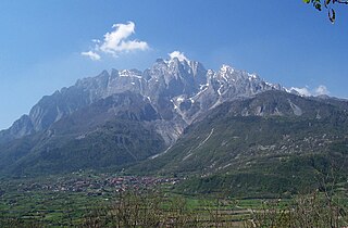
Monte Cistella is a mountain roughly in the middle of the Lepontine Alps.

Monte Leone

Monte Leone is the highest mountain of the Lepontine Alps and is located on the border between Switzerland and Italy. The mountain stands on the extreme west of the Lepontine Alps, a few kilometres east of Simplon Pass.

Pizzo Quadro

Pizzo Quadro is a mountain of the Lepontine Alps on the Swiss-Italian border. With an elevation of 2,793 metres above sea level, it is the highest summit of the range lying south of the Wandfluhhorn and the Guriner Furggu. Pizzo Quadro is located between the localities of San Rocco di Prèmia (Piedmont) and Campo (Ticino).

Concarena

The Concarena is a mountain in Lombardy, northern Italy. It is multi summited and its highest peak is the Cima della Bacchetta, with a height of 2,549 m.

Monte Grammondo

Monte Grammondo is a mountain in Liguria, northern Italy, part of the Alps.

SOIUSA

SOIUSA is a proposal for a new classification system of the Alps from the geographic and toponomastic point of view. It was designed by Sergio Marazzi, Italian researcher and author of the Orographic Atlas of the Alps SOIUSA. His book was presented with the patronage of the Italian Alpine Club on 23 Jan 2006, but has yet to receive any formal acceptance.

Punta Ramiere

The Punta Ramiere or Bric Froid is a mountain in the Cottian Alps belonging to the department of Hautes-Alpes (FR) and the province of Turin (IT). It's the highest peak of the long stretch of the Po/Rhone water divide starting from the Aiguille de Scolette (north) and ending with the Monviso group (south).

Col Nudo

The Col Nudo is a mountain in the Alps located in Italy. It is the highest peak of the Venetian Prealps and the 30th most prominent summit of the Alps.

Partizione delle Alpi

The Partizione delle Alpi is a classification of the mountain ranges of the Alps, that is primarily used in Italian literature, but also in France and Switzerland. It was devised in 1926.

Cima Garlenda Mountain in Italy

Cima Garlenda is a 2141 m mountain of the Ligurian Alps, in Italy. After Monte Saccarello and Monte Frontè it is the third Ligurian summit.

Alpe Veglia and Alpe Devero Natural Park

The Alpe Veglia and Alpe Devero Natural Park was established in 1995 and is in the Ossola valley, in the Province of Verbania, Italy.

Cima Altemberg Mountain in Italy

The Altemberg is a mountain in the Pennine Alps of north-western Italy; with an elevation of 2,395 m (7,858 ft) is the highest peak of the Alpi Cusiane.

Monte Capio Mountain in Italy

The Monte Capio is a mountain in the Pennine Alps of north-western Italy; with an elevation of 2,172 m (7,126 ft) is one of the highest peaks of the Alpi Cusiane.

Monte Civrari Mountain in Italy

The Monte Civrari is a mountain of the Graian Alps, with an elevation of 2,302 m.

Monte Mongioie Mountain in Italy

The Monte Mongioie is a mountain of the Ligurian Alps located in Piedmont.

Monte Antoroto Mountain in Italy

The Monte Antoroto is a mountain of the Ligurian Alps located in Piedmont.

Cima Ciantiplagna Mountain in Italy

The Cima Ciantiplagna is a mountain in the Cottian Alps belonging to the Province of Turin (Italy).

Monte Zeda Mountain in Italy

The Monte Zeda is a mountain in the Lepontine Alps belonging to the Province of Verbano-Cusio-Ossola (Italy).

References

  1. "Pizzo Diei - peakbagger". peakbagger.com. Retrieved 8 March 2015.
  2. "Pizzo Diei - summitpost". summitpost.org. Retrieved 8 March 2015.
  3. Marazzi, Sergio (2005). Atlante Orografico delle Alpi. SOIUSA (in Italian). Priuli & Verlucca. ISBN   978-88-8068-273-8.
  4. 1 2 "Monte Cistella: il gran salone di Messer lo Diavolo" (in Italian). Ente di Gestione delle Aree Protette dell’Ossola. 2018-03-06. Retrieved 2021-05-08.
  5. Ceragioli, Filippo; Molino, Aldo; Salvatore, Mariano (2009). "509 - Pizzo Diei (2905), Monte Cistella (2880)". A piedi in Piemonte (in Italian). 3. Iter Edizioni. pp. 171–173. ISBN   9788881771400.

Bibliography

Commons-logo.svg Media related to Pizzo Diei at Wikimedia Commons