Plaine Magnien

Last updated
Plaine Magnien
Village
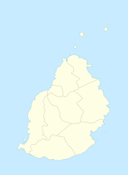
Mauritius location map.svg
Red pog.svg
Plaine Magnien
Coordinates: 20°25′43″S57°39′11″E / 20.42861°S 57.65306°E / -20.42861; 57.65306
Country Flag of Mauritius.svg Mauritius
Districts Grand Port District
Elevation
57 m (187 ft)
Population
 (2011) [1]
  Total10,443
Time zone UTC+4 (MUT)
Area code 230
ISO 3166 code MU
Climate Af
Street in Plaine Magnien Plaine magnien 2019-10-01.jpg
Street in Plaine Magnien

Plaine Magnien (formerly known as Plaisance) is a village in southeast Mauritius located in the Grand Port District.
Contents

Landmarks

The sole airport of Mauritius, Sir Seewoosagur Ramgoolam International Airport, is located in the village of Plaine Magnien.

In addition, it is the birthplace of the former Governor-General of Mauritius, Dayendranath Burrenchobay. [2]

Plaine Magnien has an all-girls State Secondary School, France Boyer de la Giroday SSS.

Saint Esprit Prestige Store, one of the most popular retail store of the village, is on the main road near the Mauritius Commercial bank.

Climate

Climate data for Plaine Magnien (Sir Seewoosagur Ramgoolam International Airport) (1991–2020)
MonthJanFebMarAprMayJunJulAugSepOctNovDecYear
Record high °C (°F)34.4
(93.9)
34.4
(93.9)
33.4
(92.1)
32.8
(91.0)
31.3
(88.3)
30.2
(86.4)
29.0
(84.2)
28.7
(83.7)
28.7
(83.7)
31.4
(88.5)
32.8
(91.0)
33.8
(92.8)
34.4
(93.9)
Mean daily maximum °C (°F)30.2
(86.4)
30.2
(86.4)
29.6
(85.3)
28.7
(83.7)
27.2
(81.0)
25.5
(77.9)
24.6
(76.3)
24.7
(76.5)
25.5
(77.9)
26.8
(80.2)
28.3
(82.9)
29.6
(85.3)
27.6
(81.7)
Daily mean °C (°F)26.9
(80.4)
26.9
(80.4)
26.5
(79.7)
25.7
(78.3)
24.0
(75.2)
22.6
(72.7)
21.7
(71.1)
21.7
(71.1)
22.2
(72.0)
23.2
(73.8)
24.6
(76.3)
26.1
(79.0)
24.3
(75.7)
Mean daily minimum °C (°F)23.7
(74.7)
23.9
(75.0)
23.6
(74.5)
22.7
(72.9)
21.0
(69.8)
19.6
(67.3)
18.9
(66.0)
18.8
(65.8)
19.0
(66.2)
20.1
(68.2)
21.2
(70.2)
22.8
(73.0)
21.3
(70.3)
Record low °C (°F)18.0
(64.4)
19.7
(67.5)
18.4
(65.1)
17.5
(63.5)
14.9
(58.8)
13.2
(55.8)
11.9
(53.4)
12.8
(55.0)
13.5
(56.3)
13.5
(56.3)
13.4
(56.1)
18.3
(64.9)
11.9
(53.4)
Average precipitation mm (inches)231.3
(9.11)
263.0
(10.35)
243.4
(9.58)
175.6
(6.91)
115.5
(4.55)
85.2
(3.35)
85.8
(3.38)
73.8
(2.91)
62.2
(2.45)
49.7
(1.96)
75.6
(2.98)
131.2
(5.17)
1,592.3
(62.69)
Average precipitation days (≥ 1.0 mm)16.216.316.715.813.613.215.813.410.48.59.011.3160.2
Mean monthly sunshine hours 233.2201.7209.9197.7193.2170.1164.9184.6203.3235.0251.6253.02,498.3
Source: NOAA [3]

See also

Transportation Service

Rental Desk:

Pingouin Car Rental SSR International Airport Level 0, Counter 9 Plaine Magnien, 51520 Mauritius

Drive into paradise with carhiremauritius.net. Explore Mauritius on your terms. Book now for flexible rentals and unforgettable adventures!

Related Research Articles

<span class="mw-page-title-main">Port Louis</span> Capital of Mauritius

Port Louis is the capital city of Mauritius. It is mainly located in the Port Louis District, with a small western part in the Black River District. Port Louis is the country's financial and political centre, and the most populous city. It is administered by the Municipal City Council of Port Louis. According to the 2018 census conducted by Statistics Mauritius, the population was 147,066.

Moka is a village in Mauritius located mainly in the Moka District. The western part of the village lies in the Plaines Wilhems District. Since 1967 it forms part of Constituency No. 8 Quartier Militaire and Moka. The village is administered by the Moka Village Council under the aegis of the Moka District Council. According to the census made by Statistics Mauritius in 2011, the population was at 8,846. The elevation is 203 meters and can be up to 425 meters in some places. Moka is directly on the other side of the Moka Range from Port Louis. The village is close to the mountain Le Pouce and the town Beau-Bassin Rose-Hill. Réduit is a suburb of the village where the State House and University of Mauritius is situated. The village is also home to the Mauritius Broadcasting Corporation and the Mahatma Gandhi Institute.

<span class="mw-page-title-main">Isle de France (Mauritius)</span> 1715–1810 French colony in the Indian Ocean

Isle de France was a French colony in the Indian Ocean from 1715 to 1810, comprising the island now known as Mauritius and its dependent territories. It was governed by the French East India Company and formed part of the French colonial empire. Under the French, the island witnessed major changes. The increasing importance of agriculture led to the "import" of slaves and the undertaking of vast infrastructural works that transformed the capital Port Louis into a major port, warehousing, and commercial centre.

<span class="mw-page-title-main">Grand Port District</span> District in Mauritius

Grand Port is a district of Mauritius, situated in the east of the island. The name means "large port" in French. The district has an area of 260.3 km2 and the estimated population was 112,997, as of 31 December 2015.

<span class="mw-page-title-main">Curepipe</span> Town in Plaines Wilhems, Mauritius

Curepipe also known as La Ville-Lumière, is a town in Mauritius, located mainly in the Plaines Wilhems District. Its eastern part lies in the Moka District. The town is administered by the Municipal Council of Curepipe. Curepipe lies at a higher elevation, often referred to as the "Central Plateau". According to the census made by Statistics Mauritius in 2018, the population of the town was at 78,618.

Sir Dayendranath Burrenchobay, KBE, CMG, CVO, GCSK was born in Plaine Magnien, Mauritius and served as the fourth governor-general of Mauritius.

<span class="mw-page-title-main">Seewoosagur Ramgoolam</span> Politician, statesman and philanthropist and the first prime minister of Mauritius (1900–1985)

Sir Seewoosagur Ramgoolam, often referred to as Chacha Ramgoolam or SSR, was a Mauritian physician, politician, and statesman. He served as the island's only chief minister, first prime minister, and fifth governor-general.

Enterprise Rent-A-Car is an American car rental agency headquartered in Clayton, Missouri, in Greater St. Louis. Enterprise is the flagship brand of Enterprise Holdings, which also owns other agencies including Alamo Rent a Car and National Car Rental. The company has historically concentrated on what it calls "home city" rentals, often people renting a car while their own was being repaired, but has expanded to airport-based rentals, especially after its parent company's acquisition of Alamo and National in 2007.

<span class="mw-page-title-main">Pamplemousses District</span> District in Mauritius

Pamplemousses is a district of Mauritius, located in the northwest of the island, and is one of the most densely populated parts of the island. The name of the district comes from the French word for grapefruits. The district has an area of 178.7 km2 and an estimated population of 139,966, as of 31 December 2015.

<span class="mw-page-title-main">Quatre Bornes</span> Town in Plaines Wilhems, Mauritius

Quatre Bornes, also known as La Ville des Fleurs, is a town in Mauritius, located mainly in the Plaines Wilhems District. Its western part lies in the Rivière Noire District. The town is administered by the Municipal Council of Quatre Bornes. Situated between the towns of Beau-Bassin Rose-Hill and Vacoas-Phoenix, Quatre Bornes is linked by roads to the north, east, south and west of Mauritius. According to the census made by Statistics Mauritius in 2015, the population of the town was at 77,308.

<span class="mw-page-title-main">Bajío International Airport</span> International airport serving León, Guanajuato, Mexico

León/Bajio International Airport ; officially Aeropuerto Internacional de Guanajuato, is an international airport situated in Silao, Guanajuato, Mexico. It is the main international airport serving the Greater León Metropolitan Area and the State of Guanajuato, which is home to a population of 6 million residents, including the cities of Celaya, Guanajuato, Irapuato, Salamanca, and San Miguel de Allende. In addition to offering domestic flights within Mexico, it serves as a gateway for international travel, connecting Central Mexico to various destinations in the United States. It serves as a focus city for Volaris and supports flight training, cargo, logistics and general aviation activities.

<span class="mw-page-title-main">Rivière du Rempart District</span> District in Mauritius

Rivière du Rempart is a district of Mauritius, located in the north-east of the island. It has an area of 147.6 km² and an estimated population of 108,005, as of 31 December 2015.

Sir Seewoosagur Ramgoolam International Airport is the primary international airport serving the island nation of Mauritius. It is located at Plaine Magnien, 48 km (30 mi) southeast of the capital city of Port Louis. The airport was previously known as the Plaisance Airport. It has direct flights to several destinations in Africa, Asia, Australia and Europe, and is home to the country's national airline, Air Mauritius. Airports of Mauritius Co. Ltd (AML) is the owner and operator of the airport, and the Government of Mauritius is the major shareholder of AML. It is named after Sir Seewoosagur Ramgoolam, the first Prime Minister of Mauritius.

Mapou is a village in northern Mauritius, located in Rivière du Rempart District. The village is administered by the Mapou Village Council under the aegis of the Rivière du Rempart District Council. According to the census by Statistics Mauritius in 2011, the population was 1,275.

<span class="mw-page-title-main">Bambous, Mauritius</span> Village in Rivière Noire District, Mauritius

Bambous is a small town in Mauritius located in the Rivière Noire District. The village is administered by the Bambous Village Council under the aegis of the Rivière Noire District Council. According to the census by Statistics Mauritius in 2011, the population was 15,345.

<span class="mw-page-title-main">Plaine Corail Airport</span> Airport in Rodrigues, Mauritius

Plaine Corail Airport is an airport located near Plaine Corail on Rodrigues, an island dependency of Mauritius. Prior to being renamed in 2017, it was known as Sir Gaëtan Duval Airport, after Gaëtan Duval (1930–1996), a former deputy Mauritian prime minister, who oversaw much of the development of Rodrigues. Airport of Rodrigues Ltd (ARL) was incorporated on 8 February 2000 as a public company.

<span class="mw-page-title-main">ATL SkyTrain</span> Landside people mover at Hartsfield-Jackson Atlanta International Airport

The ATL SkyTrain is an automated people mover (APM) at Hartsfield–Jackson Atlanta International Airport that runs 24/7 between the domestic terminal and rental car center.

Vasant Kumar Bunwaree is a former Cabinet Minister of Mauritius. He is more commonly known as Vasant Bunwaree.

The following is a timeline of the history of the city of Port Louis on the island of Mauritius.

References

  1. "Table G1 - Resident population by geographical location, whereabouts on census night and sex" (PDF). Statistics Mauritius. 2011: 2. Archived from the original (PDF) on 3 March 2016. Retrieved 8 September 2013.{{cite journal}}: Cite journal requires |journal= (help)
  2. "Intronisée vendredi: la présidente de la République racontée par ses proches". L'Express. 5 June 2015. Retrieved 2015-06-05.
  3. "World Meteorological Organization Climate Normals for 1991-2020 — Plaine Magnien". National Oceanic and Atmospheric Administration. Retrieved January 4, 2024.