A subterranean river is a river that runs wholly or partly beneath the ground surface, one where the riverbed does not represent the surface of the Earth. It is distinct from an aquifer, which may flow like a river but is contained within a permeable layer of rock or other unconsolidated materials. A river flowing below ground level in an open gorge is not classed as subterranean.

Postojna is a town in the traditional region of Inner Carniola, 35 kilometers (22 mi) from Trieste, in southwestern Slovenia. It is the seat of the Municipality of Postojna.
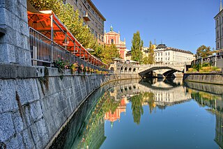
The Ljubljanica, known in the Middle Ages as the Leybach, is a river in the southern part of the Ljubljana Basin in Slovenia. The capital of Slovenia, Ljubljana, lies on the river. The Ljubljanica rises south of the town of Vrhnika and flows into the Sava River about 10 kilometres (6.2 mi) downstream from Ljubljana. Its largest affluent is the Mali Graben Canal. Including its source affluent the Little Ljubljanica, the river is 41 km (25 mi) in length. The Little Ljubljanica joins the Big Ljubljanica after 1,300 m (4,300 ft) and the river continues its course as the Ljubljanica.
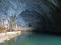
Cross Cave, also named Cold Cave under Cross Mountain, is a cave in Slovenia's Lož Valley, in the area between the Lož Karst Field, Cerknica Karst Field, and Bloke Plateau. The cave is named after nearby Holy Cross Church in Podlož. The cave is particularly noted among Karst caves for its chain of over 45 subterranean lakes of emerald green water. Extremely slow-growing calcareous formations and their fragility are the main obstacle to large-scale tourism in the cave and limit daily tourist visits to the flooded part of the cave to four people. As a result, the Cross Cave is among the best-preserved caves, opened to the public in Slovenia. The cave was prepared for visits in the 1950s by the Lož Valley Tourist Association. It was later managed by the Ljubljana Cave Research Society. Since the 1990s, it has been cared for by the Friends of Cross Cave Association . With 45 species of organisms, some not discovered until 2000, Cross Cave is the fourth-largest cave ecosystem in the world in terms of biodiversity. The cave was first documented in 1832, but the part of the cave that includes lakes and stream passages was first explored by Slovene cavers in 1926.

In geography, a confluence occurs where two or more watercourses join to form a single channel. A confluence can occur in several configurations: at the point where a tributary joins a larger river ; or where two streams meet to become the source of a river of a new name ; or where two separated channels of a river rejoin at the downstream end.

The Krka is a river in southeastern Slovenia, a right tributary of the Sava. With a length of 94.6 km (58.8 mi), it is the second-longest river flowing in its entirety in Slovenia, following the Savinja.

Vilenica Cave or Vilenica Cave at Lokev is the oldest show cave in Europe. The first tourists to the cave were recorded in 1633. It is located next to the village of Lokev in the municipality of Sežana on the Karst Plateau in southwestern Slovenia.
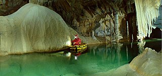
Postojna Cave is a 24,340 m (79,860 ft) long karst cave system near Postojna, southwestern Slovenia. It is the second-longest cave system in the country as well as one of its top tourism sites. The caves were created by the Pivka River.

Predjama Castle is a Renaissance castle built within a cave mouth in south-central Slovenia, in the historical region of Inner Carniola. It is located in the village of Predjama, approximately 11 kilometres from the town of Postojna and 9 kilometres from Postojna Cave.

The Pivka is a karst lost river in Slovenia. The river is 27 kilometres (17 mi) in length. The Pivka ends in Planina Cave, where it merges with the Rak River and then the Unica River. The confluence of the Pivka and the Rak is one of the largest subterranean confluences in Europe. The Pivka created Postojna Cave, the longest cave system in Slovenia as well as one of its top tourism sites.

The Rak is a stream in Inner Carniola, a traditional region of southeastern Slovenia. It sources in Zelše Caves west of the village of Zelše, flows across the Rak Škocjan karst valley for 2 kilometres (1.2 mi) and enters Weaver's Cave, where it continues for 3 kilometres (1.9 mi) and merges in Planina Cave, about 300 metres (980 ft) from its entrance, with the Pivka River to form the Unica. The confluence of the Rak and the Pivka is one of the largest subterranean confluences in Europe.

Planina is a village in the Municipality of Postojna in the Inner Carniola region of Slovenia.
Grčarevec is a village between Planina and Kalce in the Municipality of Logatec in the Inner Carniola region of Slovenia. In addition to the main settlement of the village, it also comprises the hamlets of Grčarevski Vrh to the north along the road to Kalce, and Kališe in the forest to the northeast.
The Migovec System is a 43,009-metre-long (141,000 ft) and 972-metre-deep (3,190 ft) Alpine cave system within Mount Tolmin Migovec in the Municipality of Tolmin in northwestern Slovenia. The mountain and the cave system are part of Triglav National Park. The combined system is the longest known cave in the country, followed by the Postojna Cave System.

Weaver Cave, also known as Inlet Cave, is a 2,885 metres (9,465 ft) long ponor cave in southwest Slovenia. It runs from the west (downstream) side of the Rak Škocjan Valley, where it has two entrances, and continues into Planina Cave. It is traversed by Rak Creek, part of the Ljubljanica source system. It thus forms part of the hydrological connection between Cerknica Polje and Planina Polje. Due to sumps, the stream of the Rak is very difficult to follow and was explored by divers only in 1974, when the majority of the cave was discovered in the course of a rescue expedition, and in August 2012.

The Lož Karst Field, also known as the Lož Valley, is a karst field in Inner Carniola in southwest Slovenia. It is the smallest karst field in Inner Carniola.

The Unica is a river in Slovenia. It starts as the underground confluence of the Pivka and the Rak in Planinska jama. This is the largest confluence of underground rivers in Europe. 300 meters (980 ft) further, the Unica emerges near Planina. It flows north through the Planina Karst Field through the municipalities of Postojna, Cerknica, and Logatec, where it returns underground. It then flows for about another 10 kilometers (6.2 mi) underground, emerging 142 meters (466 ft) lower at multiple springs near Vrhnika to form the Ljubljanica River.

Krka Cave is a horizontal karst cave and an occasional source of the Krka River in Dry Carniola, central Slovenia. It lies in a pocket valley between the villages of Trebnja Gorica to the east and Gradiček to the west, north of the village of Krka. Water flows into the cave from the Račna Karst Field south of the town of Grosuplje and emerges a few metres below the cave's main entrance in the karst spring of the Krka. The cave, which is of archaeological and historical significance and features great fauna diversity, is open to announced tourist visits in the presence of a guide and also used as an event venue.

Tomaž Planina was a Slovenian cave photographer, speleologist, and botanist. He was most known for his work in cave photography, laboratory rope testing, especially in connection to knots, and his contribution to the development of the single-rope technique.