
The Brienzer Rothorn is a mountain of the Emmental Alps, in Switzerland. With an elevation of 2,350 metres above sea level, the Brienzer Rothorn is the highest summit of the range. To its west lies the Tannhorn, whilst to its east are Arnihaaggen, Höch Gumme and the Brünig Pass. On its south side it overlooks Lake Brienz, whilst to the north it looks out over the Waldemme valley.

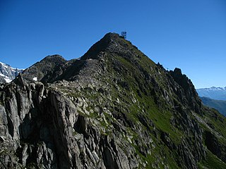
The Lauberhorn is a mountain in the Bernese Alps of Switzerland, located between Wengen and Grindelwald, north of the Kleine Scheidegg. Its summit is at an elevation of 2,472 m (8,110 ft) above sea level.

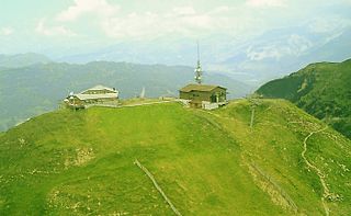
The Männlichen is a 2,343-metre (7,687 ft) mountain in the Swiss Alps located within the Canton of Berne.

Piz Bernina or Pizzo Bernina is the highest mountain in the Eastern Alps, the highest point of the Bernina Range, and the highest peak in the Rhaetian Alps. It rises 4,048.6 m and is located south of Pontresina and near the major Alpine resort of St. Moritz, in the Engadin valley with the massif partially in Italy. It is also the most easterly mountain higher than 4,000 m (13,000 ft) in the Alps, the highest point of the Swiss canton of Graubünden, and the fifth-most prominent peak in the Alps. The minor summit known as La Spedla is the highest point in the Italian Lombardy region.

The Uetliberg is a mountain in the Swiss plateau, part of the Albis chain, rising to 870 m (2,850 ft). The mountain offers a panoramic view of the entire city of Zürich and the Lake of Zurich, and lies on the boundary between the city of Zürich and the municipalities of Stallikon and Uitikon. The summit, known as Uto Kulm, is in Stallikon.

At 2,501.9 metres above sea level, Säntis is the highest mountain in the Alpstein massif of northeastern Switzerland. It is also the culminating point of the whole Appenzell Alps, between Lake Walen and Lake Constance. Shared by three cantons, the mountain is a highly visible landmark thanks to its exposed northerly position within the Alpstein massif. As a consequence, houses called Säntisblick can be found in regions as far away as the Black Forest in Germany. Säntis is among the most prominent summits in the Alps and the most prominent summit in Europe with an observation deck on the top. The panorama from the summit is spectacular. Six countries can be seen if the weather allows: Switzerland, Germany, Austria, Liechtenstein, France, and Italy.

Monte Generoso is a mountain of the Lugano Prealps, located on the border between Switzerland and Italy and between Lake Lugano and Lake Como. The western and southern flanks of the mountain lie in the Swiss canton of Ticino, whilst the north-eastern flanks are in the Italian region of Lombardy.

La Dôle is a mountain of the Jura, overlooking Lake Geneva in the westernmost part of the canton of Vaud. Rising to an altitude of 1677 meters, it is the second highest peak in the Swiss portion of the Jura, after Mont Tendre. Administratively, the summit is split between the municipalities of Gingins, Chéserex and La Rippe. The mountain is also close to and easily accessible from Saint-Cergue and the Col de la Givrine to the north, both above 1000 meters and connected to Nyon on Lake Geneva by road and by the Nyon–St-Cergue–Morez Railway. A paved road also climbs to the Chalet de la Dôle below the summit from Gingins.

The Chasseral is a mountain of the Jura Mountains, overlooking Lake Biel in the Swiss canton of Bern. With an elevation of 1,606 metres above sea level, the Chasseral is the highest summit in the canton of Bern outside the Alps. It is also both the northernmost and easternmost mountain reaching over 1,500 metres in the Jura Mountains. West of the summit is located the Chasseral Ouest, where runs the border with the canton of Neuchâtel. The Chasseral Pass is located further on the west.

The Rochers de Naye are a mountain of the Swiss Alps, overlooking Lake Geneva near Montreux and Villeneuve, in the canton of Vaud. They lie on the range separating the basin of Lake Geneva from the valley of the Sarine, on the watershed between the Rhone and the Rhine. The mountain is partially located in the canton of Fribourg, the border between the two cantons culminating on a lower summit named Grande Chaux de Naye.

The Glärnisch is a mountain massif of the Schwyz Alps, overlooking the valley of the Linth in the Swiss canton of Glarus. It consists of several summits, of which the highest, Bächistock, is 2,915 metres above sea level. Until 2013, the highest point was considered to be an unnamed point with a summit cross at 2,914 metres. The other main summits are Vrenelisgärtli and the Ruchen.

Mont Fort is a mountain of the Pennine Alps, located near Verbier in the Swiss canton of Valais. It lies on the range between the valleys of Bagnes and Nendaz, north of the Rosablanche. With a height of 3,328 metres above sea level, Mont Fort is the highest summit north of the Col de Louvie.
The Eggishorn is a mountain of the Bernese Alps, located north of Fiesch in the Swiss canton of Valais. A cable car station is located on a secondary summit named Fiescherhorli, 500 metres south of the main peak.

Piz Nair is a mountain of the Albula Alps in Switzerland, overlooking St. Moritz in the canton of Graubünden. The peak is easily accessible from the village with a funicular and a cable car; the upper station unloads 30 metres (100 ft) below the summit. Below the summit to the east is the Corviglia ski area.

The Crêt du Midi is a mountain of the Pennine Alps, overlooking Vercorin in the canton of Valais. The summit is accessible by cable car from Chalais or Vercorin.
The Unterrothon is a mountain of the Swiss Pennine Alps, overlooking Zermatt in the canton of Valais. It is located west of the Oberrothorn, on the range north of the Findel Glacier.
Piz Scalottas is a mountain of the Plessur Alps, located near Lenzerheide in the canton of Graubünden, Switzerland.
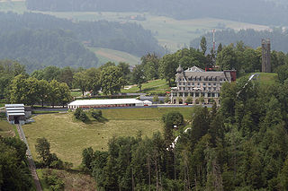
The Gurten is a mountain situated just to the south of Bern, the capital city of Switzerland. It is 858 metres (2,815 ft) high, and the summit yields views of Bern, of the Jura mountains and of the Alps.
The Tête aux Chamois is a summit of the Diablerets massif, overlooking the Col du Pillon in the canton of Vaud. It is accessible by aerial tramway from the Col du Pillon and from Reusch via Oldenegg. From the summit of the Tête aux Chamois another aerial tramway leads to the summit of the Sex Rouge and the nearby Tsanfleuron Glacier.


