
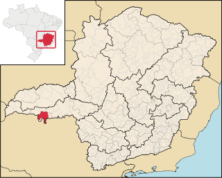
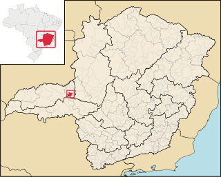
Planura is a municipality in the west of the Brazilian state of Minas Gerais. As of 2020 the population was 12,292 in a total area of 318 km2. [1] It became a municipality in 1962.
Planura is a municipality in the west of the Brazilian state of Minas Gerais. As of 2020 the population was 12,292 in a total area of 318 km2. [1] It became a municipality in 1962.
Planura belongs to the statistical micro-region of Frutal. It is located in the center of the rich region of western Minas Gerais known as the Triângulo Mineiro at an elevation of 492 meters. The Rio Grande, dammed to form the Represa de Porto Colômbia, forms the southern boundary. Neighboring municipalities are:
Important distances are:
The first settlement began on lands belonging to João Januário da Silva e Oliveira, on the banks of the Rio Grande. The first group of houses was known as Porto do Cemitério, later changing the name to Esplanada. In 1938 it became a district of Frutal with the name Nova Esplanada. In 1962 it became a municipality. The growth of the town has been due to the building of the Usina Hidrelétrica de Porto Colômbia, in the 1970s. The name is due to the flat lands of the region. [4]
The most important economic activities are cattle raising, commerce, royalties from the Porto Colômba hydroelectric station, and agriculture. The GDP in 2005 was R$433 million, half of which came from industry. Planura is in the top tier of municipalities in the state with regard to economic and social development.[ citation needed ] As of 2007, there was one banking agency in the town. There was a small retail infrastructure serving the surrounding area of cattle and agricultural lands. There were 1,106 automobiles in all of the municipality, about one for every 10 inhabitants. [5]
In the rural area there were 75 establishments occupying 76,000 hectares. About 300 persons were employed in agriculture. 41 of the farms had tractors, a ratio of one in two. There were 6,000 head of cattle in 2006, of which 2,500 head were dairy cows. In permanent crops there were 8,000 ha planted, while in perennial crops 8,300 ha were planted (in 2006). The crops with a planted area of more than 1,000 hectares were sugarcane, corn, and soybeans. The production of vegetables is aided by the abundance of water in the region, available from the Usina de Porto Colômbia. Planura is one of the largest producers of cucumber, red pepper and tomatoes in the state. [5]
In the health sector there were 03 health clinics and no hospital. In the educational sector there were 04 primary schools and 02 middle schools. [5]
The highest ranking municipality in Minas Gerais in 2000 was Poços de Caldas with 0.841, while the lowest was Setubinha with 0.568. Nationally the highest was São Caetano do Sul in São Paulo with 0.919, while the lowest was Setubinha. In more recent statistics (considering 5,507 municipalities) Manari in the state of Pernambuco has the lowest rating in the country—0,467—putting it in last place. [6]

Água Comprida is a Brazilian municipality located in the west of the state of Minas Gerais. Its population as of 2020 was estimated to be 1,992 people living in a total area of 489 km2. The city belongs to the mesoregion of Triângulo Mineiro and Alto Paranaíba and to the micro-region of Uberaba. It became a municipality in 1953.

Fronteira is a municipality in the west of the Brazilian state of Minas Gerais. The population is 18,492 in an area of 199.99 km2. It became a municipality in 1943.
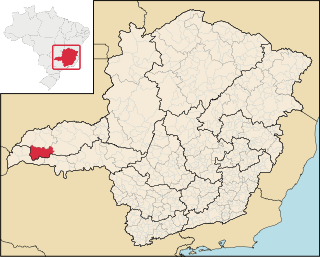
Frutal is a municipality in the west of the Brazilian state of Minas Gerais. The population, estimated in 2022 by the IBGE, is of 58.588inhabitants. The city has an area of 2,426,965km2. Frutal is located in the region known as the "Triângulo Mineiro".

Comendador Gomes is a municipality in the west of the Brazilian state of Minas Gerais. The population is 3,120 in an area of 1,041.05 km2. It became a municipality in 1948.

Morada Nova de Minas is a municipality in the north of the Brazilian state of Minas Gerais. As of 2020 the population was 8,910 in a total area of 2,085 km2. It became a municipality in 1943.
Lontra is a municipality in the north of the Brazilian state of Minas Gerais. As of 2020, the population was 9,714 in a total area of 257 km². It became a municipality in 1993.

São João da Lagoa is a municipality in the north of the Brazilian state of Minas Gerais. As of 2020 the population was 4,932 in a total area of 990 km2. It became a municipality in 1995.

Gurinhatã is a municipality in the west of the Brazilian state of Minas Gerais. As of 2020 the population was 5,577 in a total area of 1,844 km2. It became a municipality in 1962.
Campina Verde is a municipality in the north of the Brazilian state of Minas Gerais. As of 2020 the population was 19,752 in a total area of 3,663 km². It became a municipality in 1938.
Iturama is a municipality with a total area of 401 km2 in the center-west of the Brazilian state of Minas Gerais.

Pirajuba is a municipality in the west of the Brazilian state of Minas Gerais. As of 2020, the population is 6,348 in a total area of 332 km2. It became a municipality in 1953.

São Francisco de Sales is a municipality in the west of the Brazilian state of Minas Gerais. As of 2020 the population was 6,274 in a total area of 1,129 km2. It became a municipality in 1962.

União de Minas is a municipality in the west of the Brazilian state of Minas Gerais.

São Gotardo is a Brazilian municipality located in the northwest of the state of Minas Gerais. Its population as of 2020 was 35,782 people and its land area is 854 km2. The city belongs to the mesoregion of Triângulo Mineiro e Alto Paranaiba and to the microregion of Patos de Minas. It became a municipality in 1915.

Tiros is a Brazilian municipality located in the northwest of the state of Minas Gerais. Its population as of 2020 was 6,424 people living in a total area of 2,093 km². The city belongs to the mesoregion of Triângulo Mineiro e Alto Paranaiba and to the microregion of Patos de Minas. It became a municipality in 1924.

Cruzeiro da Fortaleza is a Brazilian municipality located in the northwest of the state of Minas Gerais. Its population as of 2020 was 3,639 people living in a total area of 185 km2. The city belongs to the mesoregion of Triângulo Mineiro e Alto Paranaiba and to the microregion of Patrocínio. It became a municipality in 1963.
Romaria is a Brazilian municipality located in the northwest of the state of Minas Gerais. Its population as of 2020 was 3,520 people living in a total area of 402 km2. The city belongs to the mesoregion of Triângulo Mineiro e Alto Paranaiba and to the microregion of Patrocínio. It became a municipality in 1962.

Conceição das Alagoas is a Brazilian municipality located in the west of the state of Minas Gerais. Its population as of 2020 was estimated to be 28,346 people living in a total area of 1,348 km². The city belongs to the mesoregion of Triângulo Mineiro and Alto Paranaíba and to the micro-region of Uberaba. It became a municipality in 1938.

Campo Florido is a Brazilian municipality located in the west of the state of Minas Gerais. Its population as of 2020 was estimated to be 8,269 people living in a total area of 1,261 km². The city belongs to the mesoregion of Triângulo Mineiro and Alto Paranaíba and to the micro-region of Uberaba. It became a municipality in 1938.

Nova Ponte is a Brazilian municipality located in the west of the state of Minas Gerais. Its population as of 2020 was estimated to be 15,800 people living in a total area of 1,105 km². The city belongs to the mesoregion of Triângulo Mineiro and Alto Paranaíba and to the micro-region of Araxá. It became a municipality in 1938.
20°08′50″S48°41′52″W / 20.14722°S 48.69778°W
| | This geographical article relating to Minas Gerais is a stub. You can help Wikipedia by expanding it. |