Subduction is a geological process in which the oceanic lithosphere and some continental lithosphere is recycled into the Earth's mantle at the convergent boundaries between tectonic plates. Where one tectonic plate converges with a second plate, the heavier plate dives beneath the other and sinks into the mantle. A region where this process occurs is known as a subduction zone, and its surface expression is known as an arc-trench complex. The process of subduction has created most of the Earth's continental crust. Rates of subduction are typically measured in centimeters per year, with rates of convergence as high as 11 cm/year.

The Ring of Fire is a tectonic belt of volcanoes and earthquakes.

The Eurasian Plate is a tectonic plate that includes most of the continent of Eurasia, with the notable exceptions of the Indian subcontinent, the Arabian subcontinent and the area east of the Chersky Range in eastern Siberia. It also includes oceanic crust extending westward to the Mid-Atlantic Ridge and northward to the Gakkel Ridge.

The Australian Plate is a major tectonic plate in the eastern and, largely, southern hemispheres. Originally a part of the ancient continent of Gondwana, Australia remained connected to India and Antarctica until approximately 100 million years ago when India broke away and began moving north. Australia and Antarctica had begun rifting by 96 million years ago and completely separated a while after this, some believing as recently as 45 million years ago, but most accepting presently that this had occurred by 60 million years ago.
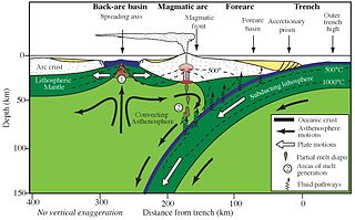
Forearc is a plate tectonic term referring to a region in a subduction zone between an oceanic trench and the associated volcanic arc. Forearc regions are present along convergent margins and eponymously form 'in front of' the volcanic arcs that are characteristic of convergent plate margins. A back-arc region is the companion region behind the volcanic arc.

The Cascadia subduction zone is a 960 km (600 mi) fault at a convergent plate boundary, about 100–200 km (70–100 mi) off the Pacific coast, that stretches from northern Vancouver Island in Canada to Northern California in the United States. It is capable of producing 9.0+ magnitude earthquakes and tsunamis that could reach 30 m (98 ft). The Oregon Department of Emergency Management estimates shaking would last 5–7 minutes along the coast, with strength and intensity decreasing further from the epicenter. It is a very long, sloping subduction zone where the Explorer, Juan de Fuca, and Gorda plates move to the east and slide below the much larger mostly continental North American Plate. The zone varies in width and lies offshore beginning near Cape Mendocino, Northern California, passing through Oregon and Washington, and terminating at about Vancouver Island in British Columbia.

Aira Caldera is a gigantic volcanic caldera that is located on the southern end of Kyushu, Japan. It is believed to have been formed about 30,000 years ago with a succession of pyroclastic surges. It is currently the place of residence to over 900,000 people. The shores of Aira Caldera are home to rare flora and fauna, including Japanese bay tree and Japanese black pine. The caldera is home to Mount Sakurajima, and the Mount Kirishima group of stratovolcanoes lies to the north of the caldera. The most famous and active of this group is Shinmoedake.

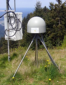
A strainmeter is an instrument used by geophysicists to measure the deformation of the Earth. Linear strainmeters measure the changes in the distance between two points, using either a solid piece of material or a laser interferometer.
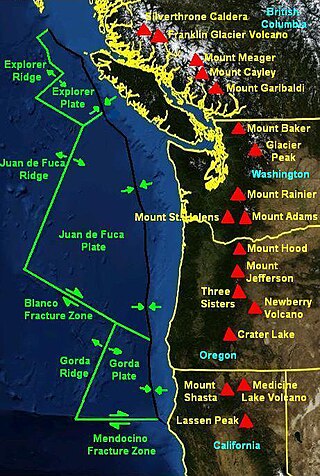
The Mendocino Triple Junction (MTJ) is the point where the Gorda Plate, the North American Plate, and the Pacific Plate meet, in the Pacific Ocean near Cape Mendocino in northern California. This triple junction is the location of a change in the broad tectonic plate motions which dominate the west coast of North America, linking convergence of the northern Cascadia subduction zone and translation of the southern San Andreas Fault system. This region can be characterized by transform fault movement, the San Andreas also by transform strike slip movement, and the Cascadia subduction zone by a convergent plate boundary subduction movement. The Gorda Plate is subducting, towards N50ºE, under the North American plate at 2.5–3 cm/yr, and is simultaneously converging obliquely against the Pacific plate at a rate of 5 cm/yr in the direction N115ºE. The accommodation of this plate configuration results in a transform boundary along the Mendocino Fracture Zone, and a divergent boundary at the Gorda Ridge. This area is tectonically active historically and today. The Cascadia subduction zone is capable of producing megathrust earthquakes on the order of MW 9.0.
The EarthScope project (2003-2018) was an National Science Foundation (NSF) funded Earth science program using geological and geophysical techniques to explore the structure and evolution of the North American continent and to understand the processes controlling earthquakes and volcanoes. The project had three components: USArray, the Plate Boundary Observatory, and the San Andreas Fault Observatory at Depth. Organizations associated with the project included UNAVCO, the Incorporated Research Institutions for Seismology (IRIS), Stanford University, the United States Geological Survey (USGS) and National Aeronautics and Space Administration (NASA). Several international organizations also contributed to the initiative. EarthScope data are publicly accessible.

Mount Tendürek is a shield volcano on the border of Ağrı and Van provinces in eastern Turkey, near the border with Iran. The volcano, which is mostly known for being near the supposed wreck site of Noah's Ark, is very large; its lava flows cover roughly 650 km2 (251 sq mi) across a swath of flat land. The mountain's two main features are the main summit crater Greater Tendürek, and a smaller crater known as Lesser Tendürek which lies to the east of the main crater. The slopes are very gentle and resemble a shield, after which the type is named. Mount Tendürek is known to have erupted viscous lava like that of volcanoes on the island of Hawaii.

A volcanic belt is a large volcanically active region. Other terms are used for smaller areas of activity, such as volcanic fields or volcanic systems. Volcanic belts are found above zones of unusually high temperature where magma is created by partial melting of solid material in the Earth's crust and upper mantle. These areas usually form along tectonic plate boundaries at depths of 10 to 50 kilometres. For example, volcanoes in Mexico and western North America are mostly in volcanic belts, such as the Trans-Mexican Volcanic Belt that extends 900 kilometres (560 mi) from west to east across central-southern Mexico and the Northern Cordilleran Volcanic Province in western Canada. In the case of Iceland, the geologist G.G. Bárdarson in 1929 identified clusters of volcanic belts while studying the Reykjanes Peninsula.

The geology of Turkey is the product of a wide variety of tectonic processes that have shaped Anatolia over millions of years, a process which continues today as evidenced by frequent earthquakes and occasional volcanic eruptions.

The geology of Chile is a characterized by processes linked to subduction, such as volcanism, earthquakes, and orogeny. The building blocks of Chile's geology were assembled during the Paleozoic Era when Chile was the southwestern margin of the supercontinent Gondwana. In the Jurassic, Gondwana began to split, and the ongoing period of crustal deformation and mountain building known as the Andean orogeny began. In the Late Cenozoic, Chile definitely separated from Antarctica, and the Andes experienced a significant rise accompanied by a cooling climate and the onset of glaciations.

The Silverthrone Caldera is a potentially active caldera complex in southwestern British Columbia, Canada, located over 350 kilometres (220 mi) northwest of the city of Vancouver and about 50 kilometres (31 mi) west of Mount Waddington in the Pacific Ranges of the Coast Mountains. The caldera is one of the largest of the few calderas in western Canada, measuring about 30 kilometres (19 mi) long (north-south) and 20 kilometres (12 mi) wide (east-west). Mount Silverthrone, an eroded lava dome on the caldera's northern flank that is 2,864 metres (9,396 ft) high, may be the highest volcano in Canada.
UNAVCO was a non-profit university-governed consortium that facilitated geology research and education using geodesy.

Santorini caldera is a large, mostly submerged caldera, located in the southern Aegean Sea, 120 kilometers north of Crete in Greece. Visible above water is the circular Santorini island group, consisting of Santorini, the main island, Therasia and Aspronisi at the periphery, and the Kameni islands at the center. It has been designated a Decade Volcano.
Volcano tectonics is a scientific field that uses the techniques and methods of structural geology, tectonics, and physics to analyse and interpret physical processes and the associated deformation in volcanic areas, at any scale.

In volcanology, deformation is any change in the shape of a volcano or the land surrounding it. This can be in the form of inflation, which is a response to pressurization, or deflation, which is a response to depressurization. Inflation is represented by swelling of the ground surface, a volcanic edifice, or a subsurface magma body. It can be caused by magma accumulation, exsolution of volatiles, geothermal processes, heating, and tectonic compression. Deflation is represented by shrinking of the ground surface, a volcanic edifice, or a subsurface magma body. It can be caused by magma withdrawal, volatile escape, thermal contraction, phase changes during crystallization, and tectonic extension. Deformation is a key indicator of pre-eruptive unrest at many active volcanoes. The term bradyseism is used in the volcanological literature to mean the vertical ground movements associated with the Phlegraean Fields volcanic area west of Naples, Italy.
The U.S. National Science Foundation's Geodetic Facility for the Advancement of Geoscience is a geophysical facility for geoscience research and education. It focuses on research of Earth's surface deformation with enhanced temporal and spatial resolution—the field of geodesy. GAGE is one of the two premier geophysical facilities in support of geoscience and geoscience education of the National Science Foundation (NSF). The other geophysical facility is the Seismological Facility for the Advancement of Geoscience.