
Vienna is the national capital, largest city, and one of nine states of Austria. Vienna is Austria's most populous city, with about 1.9 million inhabitants, and its cultural, economic, and political center. It is the 6th-largest city by population within city limits in the European Union.

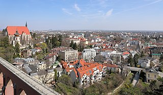
Liberec is a city in the Czech Republic. It is on the Lusatian Neisse and surrounded by the Jizera Mountains and Ještěd-Kozákov Ridge. It is the fifth-largest city in the Czech Republic.
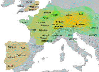
The Hallstatt culture was the predominant Western and Central European culture of Late Bronze Age from the 12th to 8th centuries BC and Early Iron Age Europe from the 8th to 6th centuries BC, developing out of the Urnfield culture of the 12th century BC and followed in much of its area by the La Tène culture. It is commonly associated with Proto-Celtic and Celtic populations in the Western Hallstatt zone and with (pre-)Illyrians in the eastern Hallstatt zone.

The Morava is a river in Central Europe, a left tributary of the Danube. It is the main river of Moravia, which derives its name from it. The river originates on the Králický Sněžník mountain in the north-eastern corner of Pardubice Region, near the border between the Czech Republic and Poland and has a vaguely southward trajectory. The lower part of the river's course forms the border between the Czech Republic and Slovakia and then between Austria and Slovakia.
Mödling is the capital of the Austrian district of the same name located approximately 14 km south of Vienna.

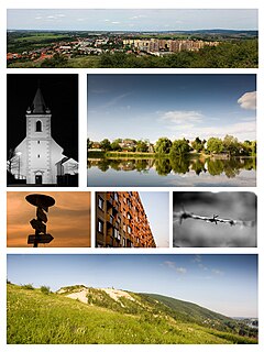
Břeclav is a town in the South Moravian Region of the Czech Republic. It has about 25,000 inhabitants.

Mikulov is a town in Břeclav District in the South Moravian Region of the Czech Republic. It has about 7,500 inhabitants. The historic centre of Mikulov is well preserved and historically significant and is protected by law as urban monument reservation.

Gloggnitz is a mountain town in the Neunkirchen district of Lower Austria, Austria.
Devínska Nová Ves is a borough of Bratislava, the capital of Slovakia. Its western borders are formed by the Morava River, which also forms the national border between Slovakia and Austria.

Hollabrunn is a district capital town in the Austrian state of Lower Austria, on the Göllersbach river.

Groß-Enzersdorf is a town and municipality in the district of Gänserndorf in the Austrian state of Lower Austria, directly to the east of Vienna and north of the river Danube. Apart from the town itself, it also comprises 7 subordinated municipalities.

The Sulm is a river in Southern Styria, Austria. It is 29.3 km (18.2 mi) long. Its two source rivers Schwarze and Weiße Sulm both originate at the eastern slopes of the Koralpe. It flows eastwards towards the Mur through the districts of Deutschlandsberg and Leibnitz. The Sulm valley runs from the Western Styrian hill ranges to the Eastern Styrian hills and lowlands.
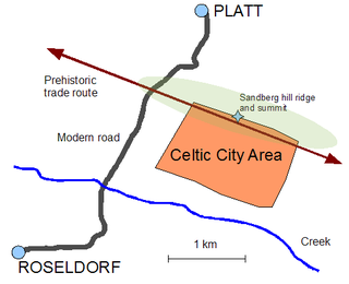
The Sandberg, a hill ridge in the northwestern part of the Weinviertel region of Lower Austria approximately 70 km north of Vienna, has recently emerged as one of the potentially most important archeological sites of the middle La Tène culture in Central Europe. The settlement which flourished there was not fortified, and therefore does not qualify as an oppidum. However, what is known to date suggests that it was not only large but also a wealthy and powerful center for trade, culture, religion and political power between southern Bohemia and the Danube valley. Its inhabitants are likely to have been Boii, or belonged to a Celtic tribe that was under their direct influence.
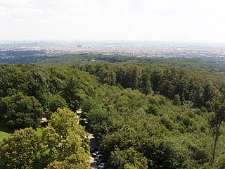
The Gallitzinberg is a forested hill in the West of Austria's capital, Vienna. While it is relatively unconspicous in the broader context of the Northeastern end of the Wienerwald mountain range, it is nevertheless remarkable because of its multifaceted history, and because it functions as an important recreational area in the Western uphill part of the densely populated Ottakring district.
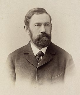
Moriz von Kuffner was a Jewish-Austrian industrialist, art collector, mountaineer and philanthropist. From the 1880s to the early 1910s he made a fortune in the brewery business, and became a significant sponsor of Vienna's social and cultural life as well as a mentor of astronomy. Moriz von Kuffner was forced to sell his Austrian assets and to leave Vienna in 1938.

The Krkonoše, Karkonosze or Giant Mountains are a mountain range located in the north of the Czech Republic and the south-west of Poland, part of the Sudetes mountain system. The Czech-Polish border, which divides the historic regions of Bohemia and Silesia, runs along the main ridge. The highest peak, Sněžka, is the Czech Republic's highest point with an elevation of 1,603 metres (5,259 ft).

The Wachau is an Austrian valley with a picturesque landscape formed by the Danube river. It is one of the most prominent tourist destinations of Lower Austria, located midway between the towns of Melk and Krems that also attracts "connoisseurs and epicureans" for its high-quality wines. It is 36 kilometres (22 mi) in length and was already settled in prehistoric times. A well-known place and tourist attraction is Dürnstein, where King Richard the Lionhearted of England was held captive by Duke Leopold V. The architectural elegance of its ancient monasteries, castles and ruins combined with the urban architecture of its towns and villages, and the cultivation of vines as an important agricultural produce are the dominant features of the valley.
Gonsenheim is a borough in the northwest corner of Mainz, Germany. With about 25,000 inhabitants, it is one of the most populated borough of Mainz and comes before Oberstadt and after Neustadt as the second biggest part of the capital town.
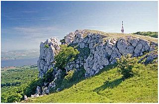
Děvín German: Mayden Berg; ; is the highest (double-peaked) mountain of Pavlov Hills, northern part of, Moravia Czech Republic. Located nearby of the historical border between Austria and Moravia (9,2 km), and right on trace where runs line of drainage divide of Upper Dyje drainage and Dyje/Morava mesodrainage.

The Northern Alaska earthquake of 1958 struck in an unusual part of state, near the small city of Huslia, about 415 km from Fairbanks. The mb 7.3 earthquake is one of two magnitude 7.0 or greater earthquakes recorded north of 65° latitude, the other being the 1933 Baffin Bay earthquake, and is one of the strongest earthquakes within the interior of Alaska. The earthquake was a result of compression of the crust due to the subduction of the Pacific Plate under the North American Plate.

