Krakatoa, also transcribed Krakatau, is a caldera in the Sunda Strait between the islands of Java and Sumatra in the Indonesian province of Lampung. The caldera is part of a volcanic island group comprising four islands. Two, Lang and Verlaten, are remnants of a previous volcanic edifice destroyed in eruptions long before the infamous 1883 eruption; another, Rakata, is the remnant of a much larger island destroyed in the 1883 eruption.

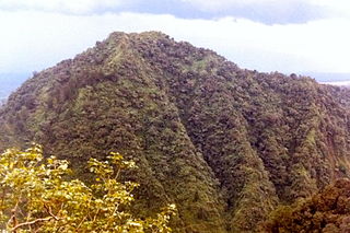
Mount Merapi, is an active stratovolcano located on the border between the province of Central Java and the Special Region of Yogyakarta, Indonesia. It is the most active volcano in Indonesia and has erupted regularly since 1548. It is located approximately 28 km (17 mi) north of Yogyakarta city which has a population of 2.4 million, and thousands of people live on the flanks of the volcano, with villages as high as 1,700 m (5,577 ft) above sea level.
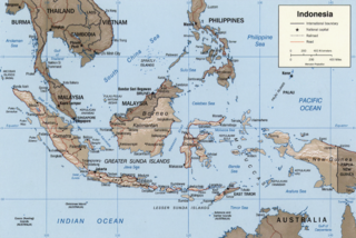
The Sunda Arc is a volcanic arc that produced the volcanoes that form the topographic spine of the islands of Sumatra, Nusa Tenggara, and Java, the Sunda Strait and the Lesser Sunda Islands. The Sunda Arc begins at Sumatra and ends at Flores, and is adjacent to the Banda Arc. The Sunda Arc is formed via the subduction of the Indo-Australian Plate beneath the Sunda and Burma plates at a velocity of 63–70 mm/year.

Mount Rinjani is an active volcano in Indonesia on the island of Lombok. Administratively the mountain is in the Regency of North Lombok, West Nusa Tenggara. It rises to 3,726 metres (12,224 ft), making it the second highest volcano in Indonesia. It is also the highest point in the Indonesian province of West Nusa Tenggara.

Kaliurang is a small town in Hargobinangun, Pakem, Sleman Regency, Special Region of Yogyakarta, Indonesia. It is located about 25 kilometres (16 mi) north of the city of Yogyakarta, on the southern slopes of Mount Merapi.

Karangetang is a volcano on the north side of Siau Island off the coast of Sulawesi, Indonesia. The island is inhabited by 22,000 people. It is one of the most active volcanoes in Indonesia having erupted 41 times since 1675. A pyroclastic flow in 1997 killed three people.
Muntilan is a district (kecamatan) in the Magelang Regency, Central Java. Muntilan is about 15 km south of Magelang, 10 km from Mungkid, 25 km north of Yogyakarta, and 90 km from the main town of Semarang located on the northern coast of Java. The town of Muntilan is on the old railway route between Kebon Polo station in Magelang and the main Tugu station in Yogyakarta. Tourists on their way to the well-known Buddhist temple Borobudur usually pass through Muntilan.
Klaten Regency is a regency in Central Java province in Indonesia. It covers an area of 655.56 km2 and had a population of 1,130,047 at the 2010 Census and 1,260,506 at the 2020 Census; the official estimate as at mid 2022 was 1,275,850. Its capital is the town of the same name; the town extends over 33.73 km2 to encompass three of the regency's districts, with a combined total of 134,423 inhabitants in mid 2022; a fourth district (Kalikotes) is part of its urban area.

Sleman Regency is an Indonesian regency on the island of Java. It is located in the north of the Yogyakarta Special Administrative Region, Indonesia, and has an area of 574.82 square kilometres (221.94 sq mi), with a population of 1,093,110 at the 2010 Census and 1,125,804 at the 2020 Census; the official estimate as at mid 2022 was 1,147,562 - comprising 569,577 males and 577,985 females. Its capital is the town of Sleman. The current regent is Kustini Sri Purnomo.

The South Western Slopes, also known as the South West Slopes, is a region predominantly in New South Wales, Australia. It covers the lower inland slopes of the Great Dividing Range, extending from north of Dunedoo through central NSW and into northeast Victoria, meeting its southwestern end around Beechworth. More than 90% of the region is in the state of New South Wales and it occupies about 10% of that state.

Mount Merbabu is a dormant stratovolcano in Central Java province on the Indonesian island of Java. The name Merbabu could be loosely translated as 'Mountain of Ash' from the Javanese combined words; Meru means "mountain" and awu or abu means "ash".

Mount Tidar is a small hill in the vicinity of Magelang, Central Java, Indonesia. It is located in the south of Magelang, on the beginning of 40 km road to Yogyakarta. On the other side of the hill, there is a golf course.

Indonesia is a volcanically active country, containing numerous major volcanoes. It has the most volcanoes of any country in the world, with 76 volcanoes that have erupted at least 1,171 times in total within historical times. The Smithsonian Institution has 141 Indonesian entries in its volcano database. Indonesia has around 130 active volcanoes that are part of the Pacific Ring of Fire, and it has suffered the highest numbers of eruptions resulting in fatalities, damage to arable land, debris flows, tsunamis, lava domes, and pyroclastic flows. Indonesia's most active volcanoes are Kelut and Mount Merapi on the island of Java. The majority of Indonesia's volcano are located on a 3,000 km long chain called the Sunda Arc. Here, the subduction of the Indian Ocean crust underneath the Asian Plate produced most of these volcanoes.

Kimpulan is a 9th to 10th century Hindu temple located in the area of Islamic University of Indonesia (UII) library in Kaliurang road, Sleman Regency, Special Region of Yogyakarta, Indonesia. The temple was buried about 5 metres (16 ft) underground. Parts of the temple have been excavated to reveal square andesite stone walls and statues of Ganesha, Nandi, and Lingam-Yoni.

In late October 2010, Mount Merapi in border of Central Java and Special Region of Yogyakarta, Indonesia began an increasingly violent series of eruptions that continued into November. Seismic activity around the volcano increased from mid-September onwards, culminating in repeated outbursts of lava and volcanic ash. Large eruption columns formed, causing numerous pyroclastic flows down the heavily populated slopes of the volcano. The 2010 eruption of Merapi was the volcano's largest since 1872.

Lake Borobudur is an ancient lake that has been suggested once existed surrounding Borobudur Buddhist monument in Kedu Plain, Central Java, Indonesia.

Barry Voight is an American geologist, volcanologist, author, and engineer. After earning his Ph.D. at Columbia University, Voight worked as a professor of geology at several universities, including Pennsylvania State University, where he taught from 1964 until his retirement in 2005. He remains an emeritus professor there and still conducts research, focusing on rock mechanics, plate tectonics, disaster prevention, and geotechnical engineering.

Selo in Java, Indonesia, is a village on the saddle of ground between two volcanoes in Central Java, Mount Merbabu and Mount Merapi. It is regularly identified as Selo, Boyolali, due to its district name and immediate administrative centre having that name.