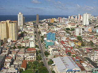
Havana is the capital and largest city of Cuba. The heart of the La Habana Province, Havana is the country's main port and commercial center. It is the most populous city, the largest by area, and the second largest metropolitan area in the Caribbean region. The population in 2012 was 2,154,454 inhabitants, and its area is 728.26 km2 (281.18 sq mi) for the capital city side and 8,475.57 km2 for the metropolitan zone.
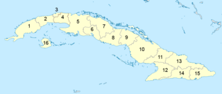
Administratively, Cuba is divided into 15 provinces and one special municipality. The current structure has been in place since August 2010, when the then-La Habana Province was divided into Artemisa Province and Mayabeque Province.

La Habana Province, formerly known as Ciudad de La Habana Province, is a province of Cuba that includes the territory of the city of Havana, the Republic's capital. The province's territory is the seat of the superior organs of the state and its provincial administration.

The Asociación de Scouts de Cuba was the national Scouting organization of Cuba from 1927 to 1961. Scouting in Cuba started in 1914, in 1927 the ASC was founded and became a member of the World Organization of the Scout Movement the same year and was suspended from WOSM membership in 1961. At the end of the 1950s, the boys-only association had about 6,500 members. Cuba is now one of only five of the world's independent countries that do not have Scouting.

Güines is a municipality and town in the Mayabeque Province of Cuba. It is located 50 km (31 mi) southeast of Havana, next to the Mayabeque River. It is the most populated town, but not the capital, of its province.
The Campeonato Nacional de Liga de Fútbol de Cuba is the top football division in Cuba. Currently, it is contested by 16 clubs and is divided into two tournaments – "Apertura" and "Clausura", with the last being the championship tournament. The champion of each tournament, decided via a playoff match ("Final"), are qualified to Supercopa Nacional de Fútbol de Cuba. The league currently has a fixed membership with each club being a representative of a Cuban province, which makes it one of the football leagues that does not have a promotion and relegation process.
Batabanó is a municipality and town in the Mayabeque Province of Cuba. It was founded in 1688.

Melena del Sur is a town and a municipality located south of the Mayabeque Province, in Cuba. It is bordered on the north and northwest by San José de las Lajas, on the east by the municipality of Güines, on the west by Batabanó, and on the south by the Gulf of Batabanó. The south shore holds the town's only beach, Mayabeque Beach. This beach is the mouth of the Mayabeque River.

San José de las Lajas is a municipality and the capital city of the newly formed Mayabeque Province of Cuba, after the segmentation of La Habana Province in 2011. It is located in the center north of the province, and is bisected by the Carretera Central.
Juan Pablo Villar Alemán is a Cuban artist specializing in drawing, painting, engraving and graphic design. Since 1989, he resides in Mexico City, Mexico.

Mayabeque River is a river of western Cuba, considered the largest in the southwestern watershed of Cuba, with an extensive fluvial network that encompasses the municipalities of Güines, San Jose de las Lajas, Jaruco, Madruga, and Melena del Sur. The old outlet in Melena del Sur is named Antiguo Mayabeque. The Antiguo (ancient) Mayabeque is still navigable by small boats in the last 5 km (3.1 mi).

Havana was founded in the sixteenth century displacing Santiago de Cuba as the island's most important city when it became a major port for Atlantic shipping, particularly the Spanish treasure fleet.
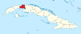
Mayabeque Province is one of two new provinces created from the former La Habana Province, whose creation was approved by the Cuban National Assembly on August 1, 2010, the other being Artemisa Province. The new provinces came in to existence on January 1, 2011.

Artemisa Province is one of the two new provinces created from the former La Habana Province, whose creation was approved by the Cuban National Assembly on August 1, 2010, the other being Mayabeque Province. The new provinces came into existence on January 1, 2011.

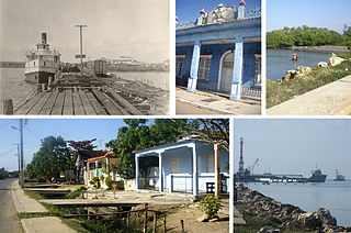
Surgidero de Batabanó, also shortened as Surgidero, is a Cuban village and consejo popular of the municipality of Batabanó, in Mayabeque Province. In 2011 it had a population of about 6,000.

The road network of Cuba consists of 60,858 km (37,815 mi) of roads, of which over 29,850 km (18,550 mi) are paved and 31,038 km (19,286 mi) are unpaved. The Caribbean country counts also 654 km (406 mi) of motorways (autopistas).

The Autopista A3, also known as Autopista Havana-Melena, is a Cuban motorway linking Havana to Melena del Sur. It is a toll-free road and has a length of 32 km (20 mi).

La Coloma is a Cuban village and consejo popular of the municipality of Pinar del Río, in Pinar del Río Province. In 2011 it had a population of about 7,000.


