Pointe des Mossettes

Last updated
Pointe des Mossettes
Pointe des Mossettes.jpg
North-west side
Highest point
Elevation 2,277 m (7,470 ft)
Prominence 193 m (633 ft) [1]
Parent peak Hauts-Forts
Coordinates 46°11′26.5″N6°48′58″E / 46.190694°N 6.81611°E / 46.190694; 6.81611 Coordinates: 46°11′26.5″N6°48′58″E / 46.190694°N 6.81611°E / 46.190694; 6.81611
Geography
Switzerland relief location map.jpg
Red triangle with thick white border.svg
Pointe des Mossettes
Location in Switzerland
Location Valais, Switzerland
Parent range Chablais Alps

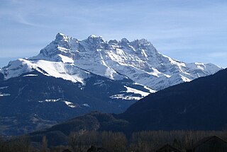
The Pointe des Mossettes (2,277 m) is a mountain of the Chablais Alps, overlooking Les Crosets in the Swiss canton of Valais. The French border runs west of the summit on a straight line, although the mountain lies on the main watershed between the Dranse river basin and the Val d'Illiez.

Mountain A large landform that rises fairly steeply above the surrounding land over a limited area

A mountain is a large landform that rises above the surrounding land in a limited area, usually in the form of a peak. A mountain is generally steeper than a hill. Mountains are formed through tectonic forces or volcanism. These forces can locally raise the surface of the earth. Mountains erode slowly through the action of rivers, weather conditions, and glaciers. A few mountains are isolated summits, but most occur in huge mountain ranges.

Chablais Alps

The Chablais Alps are a mountain range in the western Alps. They are situated between Lake Geneva and the Mont Blanc Massif. The Col des Montets separates them from the Mont Blanc Massif in the south, and the Rhône valley separates them from the Bernese Alps in the east.

Les Crosets ski resort

At 1,670 metres (5,480 ft), Les Crosets is the resort of highest altitude among those on the Swiss side of the Portes du Soleil. It is, however, one of the smallest as well. It is easily reached by skis from Châtel and Avoriaz. It has a microclimate and allows splendid views of the Dents Du Midi. The famous Swiss wall and Off Piste are accessible from Les Crosets.

Contents

The mountain is part of the international ski area Portes du Soleil and its summit can be reached by cable car from Les Crosets or Avoriaz (France).

Portes du Soleil ski area in the French Alps

Les Portes du Soleil is a major skisports destination in the Alps, encompassing thirteen resorts between Mont Blanc in France and Lake Geneva in Switzerland. With more than 650 km of marked pistes and about 200 lifts in total, spread over 14 valleys and about 1,036 square kilometres (400 sq mi), Portes du Soleil ranks among the two largest ski areas in the world. Almost all of the pistes are connected by lifts – a few marginal towns can be reached only by the free bus services in the area. The highest point of skiing is 2400 m and the lowest is 900 m. As with many other Alpine ski resorts, the lower slopes of the Portes du Soleil have snow-making facilities to extend the skiable season by keeping the lower slopes open during the warmer months.

Avoriaz French mountain resort in Upper Savoy

Avoriaz is a French mountain resort in the heart of the Portes du Soleil. It is located in the territory of the commune of Morzine. It is easily accessible from either Thonon at Lake Geneva or Cluses-junction on the A40 motorway between Geneva and Chamonix. Either way one follows the D902, Route des Grandes Alpes, to Morzine and then the D338 running from Morzine to Avoriaz. Snow chains are often necessary. Avoriaz is built on a shelf high above the town of Morzine, which is among the pioneering towns of skiing with its first lifts dating back to the early 1930s. Today Avoriaz is one of the major French ski destinations catering for all standards of skiing and ranks among the top snowboarding destinations of the world. Apart from snow-based pursuits, Avoriaz is also a centre for trekking, golf, VTT and other outdoor activities during the summer. Cars are forbidden in Avoriaz. The station is designed to be fully skiable. Other transport around the resort includes horse-drawn sleighs and snowcats during winter.

See also

Related Research Articles

Swiss Alps portion of the Alps mountain range that lies within Switzerland

The Alpine region of Switzerland, conventionally referred to as the Swiss Alps, represents a major natural feature of the country and is, along with the Swiss Plateau and the Swiss portion of the Jura Mountains, one of its three main physiographic regions. The Swiss Alps extend over both the Western Alps and the Eastern Alps, encompassing an area sometimes called Central Alps. While the northern ranges from the Bernese Alps to the Appenzell Alps are entirely in Switzerland, the southern ranges from the Mont Blanc massif to the Bernina massif are shared with other countries such as France, Italy, Austria and Liechtenstein.

Diablerets mountain in the Bernese Alps, Switzerland

The Diablerets are a huge ice-covered mountain massif of the Alps, culminating at the Sommet des Diablerets at 3,210 metres (10,530 ft) above sea level and straddling the border between the Swiss cantons of Vaud (VD) and Valais (VS). The northeastern part of the massif stretches also into the canton of Bern (BE).

Massif des Écrins mountain range

The mountains of the Massif des Écrins form the core of the Écrins National Park in France.

Grandes Jorasses mountain in the Mont Blanc massif in the Alps

The Grandes Jorasses is a mountain in the Mont Blanc massif, on the boundary between Haute-Savoie in France and Aosta Valley in Italy.

Aiguille du Midi mountain

The Aiguille du Midi is a mountain in the Mont Blanc massif within the French Alps. It is a popular tourist destination and can be directly accessed by cable car from Chamonix that takes visitors close to Mont Blanc.

Mont Pelvoux mountain

Mont Pelvoux is a mountain in the Massif des Écrins in the French Alps.

Aravis Range mountain in France

The Aravis is a mountain range in Savoie and Haute-Savoie, eastern France. It is part of the French Prealps, a lower chain of mountain ranges west of the main chain of the Alps. Its highest summit is the Pointe Percée, at 2753m. The orientation of the Aravis is north-south, and it stretches from Cluses in the north, to Ugine in the south. The Bornes massif, sometimes considered part of the Aravis, lies to its west. The Aravis is separated from the Chablais mountains in the north-east by the Arve river valley, and from the Graian Alps in the south-east by the Arly river valley.

Bauges mountain range

The Bauges Mountains is a mountain range in eastern France, stretching from the city of Annecy to the city of Chambéry, which is part of the French Prealps.

La Dôle mountain

La Dôle is a mountain of the Jura, overlooking Lake Geneva in the westernmost part of the canton of Vaud. Rising to an altitude of 1677 meters, it is the second highest peak in the Swiss portion of the Jura, after Mont Tendre. Administratively, the summit is split between the municipalities of Gingins, Chéserex and La Rippe. The mountain is also close to and easily accessible from Saint-Cergue and the Col de la Givrine to the north, both above 1000 meters and connected to Nyon on Lake Geneva by road and by the Nyon–St-Cergue–Morez Railway. A paved road also climbs to the Chalet de la Dôle below the summit from Gingins.

La Chavanette mountain pass

Le Pas de Chavanette, also known as the "Mur Suisse" or "Swiss Wall", is a particularly steep and difficult piste in the Portes du Soleil ski area, on the border between France and Switzerland. It can be reached from the French resort of Avoriaz and from the Swiss towns of Les Crosets and Champéry. Effectively, one starts the run standing on the Swiss-French border, plunging down the Swiss side of the mountain towards Les Crosets.

Vanoise massif mountains in France

The Vanoise massif is a mountain range of the Graian Alps, located in the Western Alps. After the Mont Blanc Massif and the Massif des Écrins it is the third highest massif in France, reaching a height of 3,885m at the summit of Grande Casse. It lies between Tarentaise Valley to the north and the Maurienne valley in the south. The range is the site of France's first National Park in 1963, the Vanoise National Park. The ski resorts of Tignes and Val-d'Isère and the 2,770m high Col de l'Iseran are located in the eastern part of the range.

Pointe des Grands mountain

The Pointe des Grands is a mountain of the Mont Blanc Massif, located on the border between France and Switzerland, north-west of the Aiguille du Tour.

Pointe des Berons mountain in Switzerland

The Pointe des Berons is a mountain of the Mont Blanc Massif, located on the border between Switzerland and France. It lies approximately halfway between the Col de Balme and the Aiguille du Tour. The east (Swiss) side is covered by the Glacier des Berons.

The Bornes Massif is a mountainous massif in the north French Prealps in the département of Haute-Savoie. It has 20 peaks higher than 2000 m and is a popular destination for winter sports. The Massif is the source of the celebrated cheese Reblochon.

Croix de Culet mountain in Switzerland

The Croix de Culet is a mountain of the Chablais Alps, overlooking Champéry in the canton of Valais. It lies between the valleys of Les Crosets and Planachaux.

Pointe de la Plaine Morte

The Pointe de la Plaine Morte is a mountain of the Bernese Alps, located on the border between the Swiss cantons of Bern and Valais. It overlooks the large and flat glacier named Plaine Morte Glacier, from the south-west side.

References

  1. Retrieved from the Swisstopo topographic maps. The key col is the Pas de Cuboré (2,084 m).