
A house is a single-unit residential building. It may range in complexity from a rudimentary hut to a complex structure of wood, masonry, concrete or other material, outfitted with plumbing, electrical, and heating, ventilation, and air conditioning systems. Houses use a range of different roofing systems to keep precipitation such as rain from getting into the dwelling space. Houses may have doors or locks to secure the dwelling space and protect its inhabitants and contents from burglars or other trespassers. Most conventional modern houses in Western cultures will contain one or more bedrooms and bathrooms, a kitchen or cooking area, and a living room. A house may have a separate dining room, or the eating area may be integrated into another room. Some large houses in North America have a recreation room. In traditional agriculture-oriented societies, domestic animals such as chickens or larger livestock may share part of the house with humans.
Awdal is an administrative region (gobol) in western Somaliland. It was separated from Woqooyi Galbeed and became a province in 1984 and is the most northwesterly province of Somaliland. To the east it borders Maroodi Jeex and Sahil; to its north-west it borders Djibouti; to its south and south-west lies Ethiopia; and the Gulf of Aden to its north. The province has an estimated population of 673,263. The region comprises the four districts of Borama, the regional capital, Baki, Lughaya, and Zeila.

Javanese is a Malayo-Polynesian language spoken by the Javanese people from the central and eastern parts of the island of Java, Indonesia. There are also pockets of Javanese speakers on the northern coast of western Java. It is the native language of more than 98 million people.

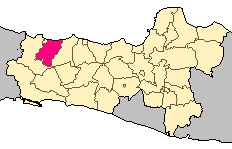
Central Java is a province of Indonesia, located in the middle of the island of Java. Its administrative capital is Semarang. It is bordered by West Java in the west, the Indian Ocean and the Special Region of Yogyakarta in the south, East Java in the east, and the Java Sea in the north. It has a total area of 32,800.69 km2, with a population of 36,516,035 at the 2020 Census making it the third-most populous province in both Java and Indonesia after West Java and East Java. The official estimate as at mid 2021 was 36,742,501. The province also includes the island of Nusakambangan in the south, and the Karimun Jawa Islands in the Java Sea.

Lampung, officially the Province of Lampung, is a province of Indonesia. It is located on the southern tip of the island of Sumatra. It has a short border with the province of Bengkulu to the northwest, and a longer border with the province of South Sumatra to the north. It is the original home of the Lampung people, who speak their own language, and possess their own written script. Its capital is Bandar Lampung.

East Nusa Tenggara is the southernmost province of Indonesia. It comprises the eastern portion of the Lesser Sunda Islands, facing the Indian Ocean in the south and the Flores Sea in the north. It consists of more than 500 islands, with the largest ones being Sumba, Flores, and the western part of Timor; the latter shares a land border with the separate nation of East Timor. The province is subdivided into twenty-one regencies and the regency-level city of Kupang, which is the capital and largest city.
Kulon Progo Regency is one of the four regencies within the Yogyakarta Special Region, Indonesia. It is located on the island of Java. The regency's name stems from the fact that it is situated to the west of the Progo River. The capital is Wates. The greatest part of the population of the regency work as farmers. Kulon Progo Regency is surrounded by the Menoreh Hills. The area of the regency is 586.27 km2, and the population was 388,755 at the 2010 census and 436,395 at the 2020 census.

Magelang is one of six cities in Central Java that are administratively independent of the regencies in which they lie geographically. Each of these cities is governed by a mayor rather than a bupati. Magelang city covers an area of 18.12 km2 and has a population of 118,227 at the 2010 census and 121,526 at the 2020 census. It is located in the middle of the Magelang Regency, between Mount Merbabu and Mount Sumbing in Central Java Province, Indonesia, and lies 43 km north of Yogyakarta, 15 km north of Mungkid and 75 km south of Semarang, the capital of Central Java.

Tegal is a city in the northwest part of Central Java of Indonesia. It is situated on the north coast of Central Java, about 175 kilometres (109 mi) from Semarang, the capital of the province. It had a population of 239,599 at the 2010 Census and 276,734 at the 2015 Census. Its built-up area made up of Tegal Municipality and 12 districts spread over Tegal and Brebes Regencies was home to 1,366,858 inhabitants as of 2010 census. It is administratively separate from Tegal Regency, which borders it to the south and east; Brebes Regency borders it to the west.

A warung is a type of small family-owned business — a small retail, eatery or café — in Indonesia. A warung is an essential part of daily life in Indonesia. In the passage of time, the term warung has slightly shifted — especially among foreign visitors, expatriates, and people abroad — to refer more specifically to a modest Indonesian eatery or a place that sells Indonesian retail things. But for the majority of Indonesians, the meaning is still a small, neighborhood convenience shop, often a front room in a family's home.

Gumare or Gomare is a rural village located in the North-West District of Botswana, near the Okavango Delta. The population of Gumare was 6,067 in 2001 census, but had risen to 8,532 iby the 2011 census.

Arroyo Seco is a town in Arroyo Seco Municipality located in the far north of the Mexican state of Querétaro. Its territory is part of the Sierra Gorda Biosphere Reserve of Querétaro. The municipality is centered on the small town of Arroyo Seco, which was established as a military outpost then given town status in 1833 under the name of Villa de Guadalupe before changing to its current name. The town gained municipal status in 1931. The area is very rural with most people living in communities of under 100 people, with significant Pame communities. It has a traditional economy based on agriculture, livestock and forestry but it is also one of the poorest in Mexico, with high rates of emigration, especially sending migrant workers to the United States. It is estimated that one in four households in the municipality receives money from family members in this country. The municipality is also home to one of five Franciscan mission complexes built under the tenure of Junípero Serra, located in the community of Concá.

Indramayu Regency is a regency (kabupaten) of West Java province of Indonesia. It covers an area of 2,099.42 km2, and had a population of 1,663,737 at the 2010 census and 1,834,434 at the 2020 census; the official estimate as at mid 2021 was 1,851,383. The town of Indramayu is its capital.
Tegal Regency is one of the regencies in the northwest part of Central Java province of Indonesia, with an area of 878.79 km2 (339.30 sq mi). The administrative center used to be in Tegal City, in the northwest corner of the regency, but then Tegal City was administratively separated from the regency and formed into its own territory. The city was later replaced as the administrative center of Tegal Regency by Slawi Town, which is a suburb about 20 km (12 mi) to the south of the city and within the district boundary. The regency had a population of 1,394,839 at the 2010 Census and 1,596,996 at the 2020 Census.

Dila District is a district of Paktika Province, Afghanistan. The district is within the heartland of the Sulaimankhel tribe of Ghilji Pashtuns.

The Cross River National Park is a national park of Nigeria, located in Cross River State, Nigeria. There are two separate sections, Okwangwo and Oban . The park has a total area of about 4,000 km2, most of which consists of primary moist tropical rainforests in the North and Central parts, with mangrove swamps on the coastal zones. Parts of the park belong to the Guinea-Congolian region, with a closed canopy and scattered emergent trees reaching 40 or 50 meters in height.

Sumbawa or Samawa people are an ethnic group of people native to the western and central region of Sumbawa Island, which comprises West Sumbawa Regency and Sumbawa Regency. The Sumbawa people refer themselves as Tau Samawa people and their language is the Sumbawa language. Neither the Bimanese nor the Sumbawa people have alphabets of their own; they use the alphabets of the Bugis and the Malay language indifferently. The majority of the Sumbawa people practice Islam. The Sumbawa people once established their own government which became the Sumbawa Sultanate and lasted until 1931.

Iqro is a textbook used in Indonesia and Malaysia for learning Arabic letters and pronunciation. It was originally published in early 1990s, authored by As'ad Humam and a team known as "Team Tadarus AMM". Iqro is a stepping-stone for reading the Quran in its original Arabic, given that these countries do not use Arabic outside religious contexts.

Kedungbanteng is a district located in the eastern part of Tegal Regency, Central Java, Indonesia. The Kedungbanteng district is 8 km drive from the center of regency, namely Slawi Town through southern of Pangkah district. The central government is located in the village of Kedungbanteng.

Pekarangan is a type of tropical home garden developed in Indonesia, mainly in Java. Pekarangans typically contain plants, while some possess animals and structures such as pens and bird cages. The gardens yield food for subsistence and income, and plants for ornamental use. Along with their subsistence and commercial uses, they are used for social interactions and yield sharing and provide materials for cultural ceremonies and religious practices. Some pekarangans are made, maintained, and spatially arranged according to local values. Home gardens of this kind may have existed for several thousand years, but their first mention is found in a Javanese chronicle that was written in 860 AD. In 2010, around 103,000 square kilometers (40,000 sq mi) of Indonesian land were used for gardens of this sort.


