The Warsaw Metro is a rapid transit underground system serving the Polish capital Warsaw. It currently consists of two lines, the north-south Line M1 which links central Warsaw with its densely populated northern and southern districts, and the east-west Line M2, of which the westernmost segment is in construction. A third line (M3) is still being planned. The system is operated by Metro Warszawskie sp. z o.o., a company owned by the city, and managed by Zarząd Transportu Miejskiego w Warszawie. It is currently the only metro system in Poland.
Metro Świętokrzyska is a transfer station on Lines M1 and M2 of the Warsaw Metro, located under the crossing of Świętokrzyska and Marszałkowska streets in the borough of Śródmieście. The station on M1 was opened on 11 May 2001 as part of the extension of M1 north from Centrum to Ratusz. Świętokrzyska is used as a change-over between Lines M1 and M2, and is the only transfer between M1 and M2 metro lines. The station on the second metro line fully opened for passenger use on 8 March 2015 as part of the inaugural stretch of Line M2 between Rondo Daszyńskiego and Dworzec Wileński. It was designed by Polish architect Andrzej M. Chołdzyński and constructed by Metroprojekt. Murals were created by Wojciech Fangor, artist of the Polish School of Posters.
Ratusz Arsenał is a station on Line M1 of the Warsaw Metro, Poland, located under the Plac Bankowy in the borough of Śródmieście. The station was opened on 11 May 2001 as the northern terminus of the extension from Centrum. On 20 December 2003 the line was extended further north to Dworzec Gdański. It takes its name from the Warsaw City Hall located on the western side of the square. Warsaw Arsenal is also located near the station. It is the closest station to the Warsaw Old Town and the Royal Castle.

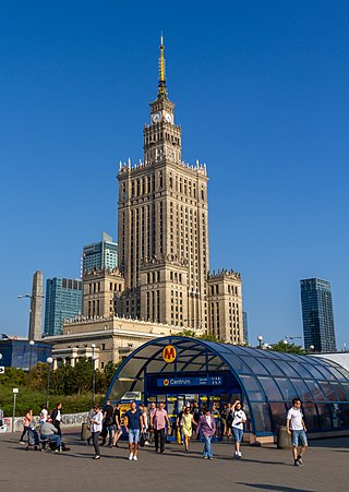
Centrum is a station on Line M1 of the Warsaw Metro, located under Plac Defilad, a square in the borough of Śródmieście, next to the Dmowski roundabout, where the two main streets, Marszałkowska and Aleje Jerozolimskie, intersect. It is located close to the Palace of Culture and Science and connections can be made, via Pasaż Wisławy Szymborskiej and Aleje Jerozolimskie at ground level, to Warszawa Śródmieście railway station which is in turn directly connected to Warszawa Centralna railway station. It has two levels: the lower one contains the platforms and the upper one is a shopping mall.

Plac Wilsona is a station on Line M1 of the Warsaw Metro. It is located below Wilson Square in the Żoliborz district in northern Warsaw.

Metro Wierzbno is a station on Line M1 of the Warsaw Metro, located in the Wierzbno neighbourhood, from which it derives its name. The station is in the Mokotów district of Warsaw.

Metro Racławicka is a station on Line M1 of the Warsaw Metro. It is located in the Mokotów district of Warsaw, at the junction of ulica Racławicka and Aleja Niepodległości.

Metro Pole Mokotowskie is a station on Line M1 of the Warsaw Metro, located in the Mokotów district of Warsaw. It is named after the Pole Mokotowskie park nearby. It is located very close to the Warsaw School of Economics.

Metro Stokłosy is a station on Line M1 of the Warsaw Metro, located in the Stokłosy neighbourhood of the Ursynów district in south Warsaw at the junction of Aleja KEN, Herbsta Street and Jarzębowskiego Street. It is situated between Imielin and Ursynów stations.
Metro Wilanowska is a station on Line M1 of the Warsaw Metro, located in the Mokotów district of Warsaw at the junction of Aleja Niepodległości, Puławska Street, and Aleja Wilanowska, all main streets of Warsaw. It is an important transfer point to a large bus station, serving routes through the city and to the surrounding towns and villages.
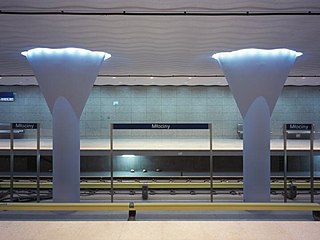
Młociny is a Warsaw Metro station serving as a northern terminus to Line M1. It is situated within Warsaw administrative boundaries and Public Transport Authority's ticketing zone 1, in the osiedle Młociny of the dzielnica Bielany, in a close proximity to Warsaw's ArcelorMittal steelworks. The station opened on 25 October 2008 and is the final northern extension of Line M1. It was designed by Polish architect Andrzej M. Chołdzyński.

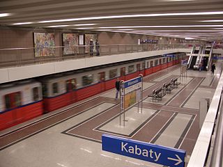
Metro Kabaty is the southern terminus of Line M1 of the Warsaw Metro, located in the Kabaty neighbourhood of the Ursynów district in the south of Warsaw, at the end of Aleja Komisji Edukacji Narodowej, the main artery of Ursynów. Tracks continue beyond the station, where they rise to surface level and go into the depot. The station is close to several bus stops. The Kabaty Forest is nearby.

Metro Natolin is a station on Line M1 of the Warsaw Metro, located in the Natolin neighbourhood of the Ursynów district in the south of Warsaw at the junction of Aleja KEN and Belgradzka. It is near Galeria Ursynów, a small local shopping centre and a local shopping street.

Dworzec Gdański is a station on Line M1 of the Warsaw Metro, located just south of the Warszawa Gdańska railway station, at the viaduct of Andersa Street over Słomińskiego Street. It is one of the major transport hubs in the northern part of the city of Warsaw. The station was opened on 20 December 2003 as the northern terminus of the extension from Ratusz. On 8 April 2005 the line was extended further north to Plac Wilsona.

Metro Imielin is a station on Line M1 of the Warsaw Metro, located in the Imielin neighbourhood of the Ursynów district in south Warsaw at the junction of Aleja KEN and Indira Gandhi Street.

Metro Służew is a station on Line M1 of the Warsaw Metro, located in the Służew district in south Warsaw, at the junction of Wałbrzyska and Rolna Streets.

Metro Ursynów is a station on Line M1 of the Warsaw Metro, located in the Ursynów district in south Warsaw, at the junction of Aleja KEN and Surowieckiego Street.

Metro Słodowiec is the 18th working station on Line M1 of the Warsaw Metro. It was opened on 23 April 2008 as the northern terminus of the extension from Marymont. On 25 October 2008, the line was extended further north to Młociny.
Warsaw has seen major infrastructural changes over the past few years amidst increased foreign investment and economic growth. The city has a much improved infrastructure with new roads, flyovers, bridges, etc. Public transport in Warsaw is ubiquitous, serving the city with buses, trams, and metro.

Nowy Świat-Uniwersytet is a station on the central part of Line M2 of the Warsaw Metro.