Pombal, Paraíba

Last updated • 4 min readFrom Wikipedia, The Free Encyclopedia
Pombal
Bandeira pombal.PNG
Brasao pombal.png
Nickname: 
Terra de Maringá (Maringá Land)
Motto: 
In Tui Honore
Brazil Paraiba Pombal location map.svg
Country Brazil
State Paraíba
Area
  Total894.099 km2 (345.214 sq mi)
Population
 (2020 [1] )
  Total32,802
Clock Tower of Pombal City, behind Old Church, downtown Pombal. Torre de Pombal.jpg
Clock Tower of Pombal City, behind Old Church, downtown Pombal.
Church in Centennial Square, in downtown. Igreja Matriz Pombal.jpg
Church in Centennial Square, in downtown.
Trans-Amazonian highway, but known as BR-230 which runs through the city. Br-230.JPG
Trans-Amazonian highway, but known as BR-230 which runs through the city.
Church of St Peter in the Neighborhood Pereiros in the city of Pombal. In the statue, Father Damien. Igreja Sao Pedro Pombal.JPG
Church of St Peter in the Neighborhood Pereiros in the city of Pombal. In the statue, Father Damien.
Old Railway Station in the city built in the provisional government of 1932. Reformed the administration of Mayor Pollyanna Feitosa in 2009. For SEMCET (Municipal Department of Culture, Sport and Tourism) to the secretary: Paul Romero Oliveira Freitas. Estacao ferroviaria Pombal.JPG
Old Railway Station in the city built in the provisional government of 1932. Reformed the administration of Mayor Pollyanna Feitosa in 2009. For SEMCET (Municipal Department of Culture, Sport and Tourism) to the secretary: Paul Romero Oliveira Freitas.
Bar Centennial, and the second floor AEUP (Association of the University of Pombal) in Centennial Square, downtown Pombal. Bar Centenario e AEUP.JPG
Bar Centennial, and the second floor AEUP (Association of the University of Pombal) in Centennial Square, downtown Pombal.
Pombal Square Shopping Center, opened in 2006 at the Centre de Pombal Pombal Center Shopping.JPG
Pombal Square Shopping Center, opened in 2006 at the Centre de Pombal
Campus UFCG Pear in the neighborhood. Capus UFCG Pombal.JPG
Campus UFCG Pear in the neighborhood.
Entrance Road of Pombal Entrada do Terminal Rodoviario Pombal.JPG
Entrance Road of Pombal
City Hall, in the neighborhood center. Prefeitura de Pombal.JPG
City Hall, in the neighborhood center.
View of the city by leaving the district pear. Vista dos Pereiras.JPG
View of the city by leaving the district pear.
Maringa 98FM radio headquarters in the town of Pombal. Radio Maringa.JPG
Maringa 98FM radio headquarters in the town of Pombal.

PombalPortuguese pronunciation: [põˈbaʊ̯] is a Brazilian municipality in the State of Paraíba. Located at an altitude of 184 meters. According to the Brazilian Institute of Geography and Statistics (IBGE), in 2020 it had an estimated population of 32,802 inhabitants. Its territorial area is 894 km2.

Contents

History

It was along the rivers that flourished early civilizations of the world, giving a new direction to human history, in turn call river civilizations. And the decisive factor in the colonization of Pombal was the Rio Piancó.

The penetration paraibano was made by agricultural and pastoral purposes.

Right in the late seventeenth century, around 1696, the pioneer Theodosius Canate, after many battles with the natives, reached the location of the landmarks of the founding of Festival of Piranhas, the right bank of the river Piancó.

The interior, hitherto unexplored was occupied by the tribes of the family Cariri - the PEGAS and PANATO.

The city received three names. The first Festival of Piranhas (1696), the last village of Nossa Senhora do Bom Sucesso (1719) and by royal charter of July 22, 1766 was elevated to the category of town with the name of Pombal. Homage to the First Minister of the king of Portugal D. José I, the Marquis of Pombal (Sebastião José de Carvalho e Melo). High category of life came the official installation to 4 May 1772.

The town became a district on October 15, 1827, and July 21, 1862 was granted city outlaws the seat of the municipality is a great brand of Luso-Brazilian ties.

The county of Pombal was established in 1831 and was supplied in 1882 and restored by the State Law No. 330 of November 11, 1898 based on Patos.

Under the State Law No. 330 of 1907 moved the headquarters to the city of Pombal.

The county of Pombal is 2 Sub-division, covering the cities of Lake and São Paulo, Danvers, São Domingos de Pombal and São Bento de Pombal.

Pombal - was the 1st Village high paraibano, and today stands as culturally Fourth (4th) oldest city in Paraíba.

Annual Festivals and Events

Each year the two parties stand in the city, the Pombal Fest, which always occurs in the month of July, commemorating the anniversary of the city, shaped out of season carnival. And the Feast of the Rosary, which occurs in October, when the first weeks of the month, extending up to about October 12, the day of children.

Geography

The city is included in the geographic area covered by the Brazilian semiarid, defined by the Ministry of National Integration in 2005. This distinction is made based precipitation index, the index of aridity and drought risk.

Monuments and Historic Buildings

There are many monuments and historic buildings in the city, like the house of culture, which was the old jail, where torture was no different to blacks and people who disobeyed the law. In the city center can find the Church of Our Lady of Good Success and Our Lady of the Rosary, and there are others just symbolic, as Centenary Square, the Pillar of Time, Cruise, and the Bandstand, where today downstairs is a bar known as "The Centenary Bar", and upstairs is a small club called AEUP (Association of University Students of Pombal). There are other parks, churches and monuments in the city, but these are the ones that attract wide attention.

University in Pombal

Since 2006, the population of Pombal protested the establishment of colleges or universities in the city. Since early 2007 the Federal University of Campina Grande UFCG is acting in the city, was first headquartered in the building of the former School Joshua BEZERRRA. And with the campus opening planned for 2010, CAIC nearby school in the district Pear. Facilities include 18 buildings and a vast land area. According to data, the second largest campus of a university in the state of Paraiba. But with the work already underway by a vast time, In July 2009, during Pombal Fest was the inauguration of the campus, he expected the presence of President Lula, but the same could not attend.

Radios

In the city there are four radio stations, the programming is varied radios Liberdade96fm, Maringá98.7fm, Opção104fm and religious radio programming is Bomsucessoam. In addition to songs from all rhythms, the radios serve as news to major news of the city where the company participates in phone calls making public complaints about abuse, politics, vandalism, corruption and crime. The radios provide full coverage of the city to city events such as Pombal Fest, Feast of the Rosary, plus exclusive interviews with established singers who make presentations in the city in times of festivity. Among the city's radio announcers stand Goddess Fernandes, Nil Alcantara Claudionou Naldo Silva Dantas and the interactivity with the people in their programs.

Notable residents

Related Research Articles

<span class="mw-page-title-main">Paraíba</span> State of Brazil

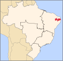
Paraíba is a state of Brazil. It is located in the Brazilian Northeast, and it is bordered by Rio Grande do Norte to the north, Ceará to the west, Pernambuco to the south and the Atlantic Ocean to the east. Paraíba is the third most densely populated state of the Northeast; João Pessoa, the sea-bordered state capital, and Campina Grande, in the interior, rank among the fifteen-largest municipalities in the Northeast of Brazil. The state is home to 1.9% of the Brazilian population and produces 0.9% of the Brazilian GDP.

<span class="mw-page-title-main">Ouro Preto</span> Municipality in Minas Gerais, Brazil

Ouro Preto, formerly Vila Rica, is a Brazilian municipality located in the state of Minas Gerais. The city, a former colonial mining town located in the Serra do Espinhaço mountains, was designated a World Heritage Site by UNESCO due to its Baroque colonial architecture. Ouro Preto used to be the capital of Minas Gerais from 1720 until the foundation of Belo Horizonte in 1897.

<span class="mw-page-title-main">São José dos Campos</span> Municipality in Southeast, Brazil

São José dos Campos is a major city and the seat of the municipality of the same name in the state of São Paulo, Brazil. One of the leading industrial and research centers with emphasis in aerospace sciences in Latin America, the city is located in the Paraíba Valley, between the two most active production and consumption regions in the country; São Paulo and Rio de Janeiro. It is the main city of the Metropolitan Region of Vale do Paraíba e Litoral Norte. A native of São José dos Campos is called a joseense. Being the second most populous non-capital city in Brazil – behind Campinas – São José dos Campos lies in the middle of the Expanded Metropolitan Complex, the first megalopolis in the Southern Hemisphere, with over thirty million inhabitants. The city's metro area also includes Greater São Paulo, Campinas, Santos and Sorocaba. The municipality concentrates many major companies and industries, such as Embraer, Panasonic, Johnson & Johnson, Ericsson, Philips, General Motors, Petrobras, Monsanto among others. São José dos Campos also holds relevant education and research institutions, as ITA, INPE, CEMADEN, IEAv, IEA, IFI, UNESP, UNIFESP, DCTA, FATEC, UNIVAP and IP%D, holding a position the puts the city as the main and largest Aerospacial Complex in Latin America. Thus, it is also considered the warlike producer centre. The Technological Park, the largest one in the country, is the only research institute in the world that converges all the three top global plane production companies, Embraer, Boeing and Airbus.

<span class="mw-page-title-main">Cachoeira Paulista</span> Municipality in Southeast Brazil, Brazil

Cachoeira Paulista is a municipality in the state of São Paulo in Brazil. It is part of the Metropolitan Region of Vale do Paraíba e Litoral Norte, in the Guaratinguetá Microregion.

<span class="mw-page-title-main">Guaratinguetá</span> Municipality in Southeast Brazil, Brazil

Guaratinguetá is a municipality in the state of São Paulo in Brazil. It is part of the Metropolitan Region of Vale do Paraíba e Litoral Norte. The population is 122,505 in an area of 752.64 km2. It is located in the region of Vale do Paraíba; prominent individuals from the area include Saint Frei Galvão, Brazilian President Rodrigues Alves and the cardiologist Dr Euryclides de Jesus Zerbini. The name of the city derives from the words in the Tupi language: gûyra (heron), tinga (white) and etá, resulting in Gûyrating'etá.

<span class="mw-page-title-main">Guarulhos</span> Municipality in Southeast, Brazil

Guarulhos is a Brazilian municipality. It is the second most populous city in the Brazilian state of São Paulo, the 13th most populous city in Brazil, and is also the most populous city in the country that is not a state capital. In the last few years it has outgrown Campinas. It is part of the Metropolitan Region of São Paulo. Its population is 1,291,784 with an area of 318.68 km2.

<span class="mw-page-title-main">Paraíba Valley</span>

The Paraíba Valley is a landform that encompasses the regions: Paraíba Valley Metropolitan Region and Northern Coast, in the state of São Paulo and Sul-Fluminense Region, in the state of Rio de Janeiro, which stands out for concentrating a considerable portion of the Brazilian economy.

<span class="mw-page-title-main">Três Rios</span> Municipality in Southeast, Brazil

Três Rios is a municipality located in the Brazilian state of Rio de Janeiro. As of 2020 its population was an estimated 82,142 inhabitants, and its area is around 322 square kilometres (124 sq mi). The current mayor of Três Rios is Joacir Barbaglio Pereira of the Liberal Party, elected in 2020 to a four-year term.

<span class="mw-page-title-main">Leopoldina, Minas Gerais</span> Brazilian municipality

Leopoldina is a Brazilian municipality in the state of Minas Gerais. It belongs to the Zona da Mata mesoregion and it located 322 kilometers southeast of Belo Horizonte, the state capital. In 2022, its estimated population was 51 145 inhabitants, according to IBGE. Its territory covers an area of 943 km2.

<span class="mw-page-title-main">Trans-Amazonian Highway</span> Major highway in Brazil

The Trans-Amazonian Highway was introduced on September 27, 1972. It is 4,000 km long, making it the third longest highway in Brazil. It runs through the Amazon forest and the Brazilian states of Paraíba, Ceará, Piauí, Maranhão, Tocantins, Pará and Amazonas, from the proximities of Saboeiro up until the town of Lábrea.

<span class="mw-page-title-main">Serra Talhada</span> City in Pernambuco, Brazil

Serra Talhada is a city in the state of Pernambuco, Brazil. It is located at 07º59'31" South and 38º17'54" West, at an altitude of 429 metres. As of 2020, its estimated population by IBGE was 86,915 people. Its area is approximately 2980 km sq.

<span class="mw-page-title-main">Santa Isabel, São Paulo</span> Place in Southeast, Brazil

Santa Isabel is a municipality in the state of São Paulo in Brazil. It is part of the Metropolitan Region of São Paulo. The population is 57,966 in an area of 363.33 km². The elevation is 655 m. It is located 60 miles east of the downtown of the city of São Paulo.

<span class="mw-page-title-main">Paraíba do Sul, Rio de Janeiro</span> Place in Southeast, Brazil

Paraíba do Sul is a municipality located in the Brazilian state of Rio de Janeiro. Its population was 44,518 (2020) and its area is 581 km².

<span class="mw-page-title-main">Patos</span> Municipality in Northeast, Brazil

Patos is a municipality of the state of Paraíba in the Northeast Region of Brazil. It is classified by the Brazilian Institute of Geography and Statistics as a sub-regional center A.

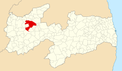
Queimadas, Paraíba is a municipality in the state of Paraíba in the Northeast Region of Brazil. The town has the seventeenth GDP and is the twelfth largest city of the state.

<span class="mw-page-title-main">São Bento, Paraíba</span> Municipality in Northeast, Brazil

São Bento, Paraíba is a municipality in the state of Paraíba in the Northeast Region of Brazil.

<span class="mw-page-title-main">Tauá</span> Municipality and city in Nordeste, Brazil

Tauá is a municipality in the state of Ceará in the Northeast region of Brazil. In 2020 it had an estimated population of 59,062 people. It is one of the largest municipalities in the state, with an area of 4,018.188 square kilometres (1,551.431 sq mi).

<span class="mw-page-title-main">Osasco</span> Municipality in Southeast, Brazil

Osasco is a municipality in São Paulo State, Brazil, located in the Greater São Paulo area and ranking 5th in population among São Paulo municipalities. According to the IBGE 2015, Osasco currently has the 9th highest gross domestic product in Brazil, and the 2nd largest in the State of São Paulo. The population is 699,944 in an area of 64.95 km2. It is among the world's more dense cities, similar in density to Tokyo and New York City. It's considered the major urban centre of the Western portion of the Greater São Paulo. It used to be a district of São Paulo City until February 19, 1962, when Osasco became a municipality of its own. The city motto is "Urbs labor", a Latin phrase that means "City work".

<span class="mw-page-title-main">1933 in Brazil</span> Brazil-related events during 1933

Events in the year 1933 in Brazil.

<span class="mw-page-title-main">BINGO (telescope)</span> Radio telescope under construction in Paraiba, Brazil

BINGO is a 40 m (130 ft) transit radio telescope currently under construction that will observe redshifted hydrogen line emission by intensity mapping to measure dark energy through baryon acoustic oscillations (BAO) in the radio frequency band.

References

7°21′28″S35°53′52″W / 7.35778°S 35.8978°W / -7.35778; -35.8978