In the 1930s, the insufficiency of the ancient Milvian Bridge as an exit from Rome along the route of the Cassia and Flaminia consular roads, together with the need to provide a scenographic entrance to the capital for the traffic coming from North, led to the planning of a series of interventions: a variant upstream of the present Via Cassia Vecchia (to be connected to a variant of Via Flaminia Vecchia) and the construction of a new bridge, which should have been called "October XXVIII" in memory of the date of the march on Rome.[1]
The project of the bridge was entrusted to Armando Brasini, who had already begun to build the church in the nearby Piazza Euclide, Villa Manzoni and his own home at the Milvian Bridge. As regards the structures, the task was entrusted to the engineer Aristide Giannelli. The project that Brasini presented to Mussolini involved a huge monumental arch that emulated the Roman triumphal arches; nonetheless, the Duce, who often made changes to the drawings of his designers, removed the arch and simplified the project. It seems that Brasini willingly accepted the change, stating that the project had been improved in terms of breadth and originality.
The works, entrusted to the company Tecnobeton, began in 1938, therefore on the eve of World War II; for this reason they were stopped in 1943, when some of the structures already built suffered damage due to war events. The works were resumed only in 1947 and completed in 1951. In the newly established Republic, the bridge should have changed its name into Ponte della Libertà (Italian for "Bridge of Freedom"). However, a name consistent with that of the first stretch of the variant to the Via Cassia – to which it would have been connected, – was finally preferred: this stretch, from the bridge to Via Antonio de Viti de Marco, was formerly called Via Caio Flaminio, then Via Flaminia nuova and finally Corso di Francia since 1959. It is in fact the first monumental bridge over the Tiber north of Rome, serving the historic route of the Via Flaminia; since 1960 it has been connected to the viaduct of Corso di Francia, which connects the Quarters Tor di Quinto and Parioli overpassing the Olympic village.
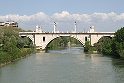
Ponte Flaminio. Below the main arch, one of the pylons of the Bailey bridge, built in the 1960s and now demolished, is visible.
In the early 1960s the bridge was closed to motor vehicles due to a structural problem on the fifth pylon, which caused a subsidence of the roadway; the restoration works were entrusted to the engineers Arrigo Carè and Giorgio Giannelli, while a Bailey bridge was set up just upstream to absorb the traffic. The bridge was reopened in 1964, when, however, the construction of the Grande Raccordo Anulare and the Fiumicino Airport had substantially reduced its function as the main entrance to Rome.
Description
The bridge, which measures 254.94 metres (836.4ft) in length by 27 metres (89ft), is spread over five arches and is made of concrete entirely covered with Roman travertine characterized by warm shades of white. Cylindrical stones and stems, bearing eagles and street lamps, rise on the two large sidewalks, raised by scenic stairways. Its profile recalls that of the neighbor Milvian Bridge, with enormously emphasized proportions, thus obtaining a monumental and imposing structure.
In the chapter In vespa of the film Caro diario (1993) by Nanni Moretti, the director / protagonist passes over the bridge – for which he expresses love – at least twice a day.
In the episode Il Cittadino, lo Stato e la Chiesa of the film Made in Italy (1965) by Nanni Loy, a bus of ACLI retirees can't access the bridge, since it is blocked due to its structural problems; the bridge is however called Ponte della Vittoria (a bridge that does not exist in Rome).
The Via Flaminia was an ancient Roman road leading from Rome over the Apennine Mountains to Ariminum (Rimini) on the coast of the Adriatic Sea, and due to the ruggedness of the mountains was the major option the Romans had for travel between Etruria, Latium, Campania, and the Po Valley. The section running through northern Rome is where Constantine the Great, allegedly, had his famous vision of the Chi Rho, leading to his conversion to Christianity and the Christianization of the Roman Empire.
The Via Cassia was an important Roman road striking out of the Via Flaminia near the Milvian Bridge in the immediate vicinity of Rome and, passing not far from Veii, traversed Etruria. The Via Cassia passed through Baccanae, Sutrium, Volsinii, Clusium, Arretium, Florentia, Pistoria, and Luca, joining the Via Aurelia at Luna.
Campo Marzio is the 4th rione of Rome, Italy, identified by the initials R. IV. It belongs to the Municipio I and covers a smaller section of the area of the ancient Campus Martius. The logo of this rione is a silver crescent on a blue background.
Parioli is the 2nd quartiere of Rome, identified by the initials Q. II.
Santa Maria dei Miracoli and Santa Maria di Montesanto are two churches in Rome.
Prima Porta is the 58th zona of Rome, identified by the initials Z. LVIII. The name Prima Porta came from an arch of the aqueduct that brought water to the Villa of Livia, which formed over Via Flaminia a sort of gateway which travellers saw as the first indication of having reached Rome (Piperno).
Fleming is a neighbourhood of Rome, Italy. Administratively it was part of Municipio XV of Rome.
The Tridente is the complex of roads formed by three straight streets of Rome (Italy), departing from Piazza del Popolo and diverging southward, taking the shape of a trident.
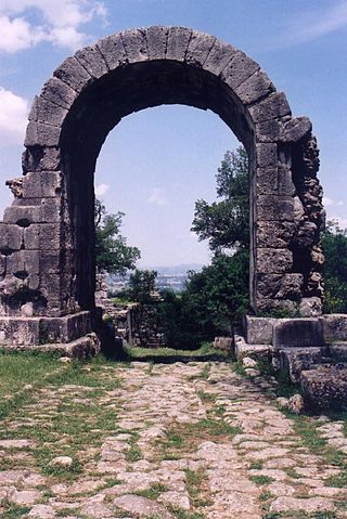
The Arch of Malborghetto is an Ancient Roman quadrifrons arch located nineteen kilometres north of Rome on the via Flaminia. Today, because of reuse over the centuries, it is part of a mass of construction which appears to be a Medieval structure at first sight. Nevertheless, the core of the structure is datable to the first half of the fourth century. The original marble coating has been completely lost.
The following outline is provided as an overview of and topical guide to Rome:
The Fontana or Fontanone di Ponte Sisto, once known as the Fontanone dei Cento Preti, is an early 17th-century, monumental fountain now located in Piazza Trilussa, facing the south end of the Ponte Sisto, in Trastevere, Rome, Italy. It was reconstructed here in the late 19th century, originally erected across the river, attached to the former building of the Collegio Ecclesiastico.
Flaminio is the 1st quartiere of the Italian capital Rome. Identified by the initials Q. I, it belongs to the Municipio II and has 13,018 inhabitants and an area of 1.1877 km2. The name is derived from the Via Flaminia.
Pinciano is the 3rd quartiere of Rome (Italy), identified by the initials Q. III. The name derives from the Pincian Hill. It belongs to the Municipio II.
Tor di Quinto is the 18th quartiere of Rome (Italy), identified by the initials Q. XVIII. It belongs to the Municipio XV.
The Piazza Euclide railway station is a railway station in Rome (Italy), on the Rome–Civitacastellana–Viterbo railway, managed by ATAC. It is the only underground stop of the line, excluding the Flaminio terminus.
Villa Glori is a 25-hectare (62-acre) city park in Rome, Italy, within the Municipio II and the quarter Parioli. It is also called Parco della Rimembranza.
Corso di Francia, informally called Corso Francia, is a street in the northern area of Rome (Italy). It runs in a south–north direction between the Quarters Parioli and Tor di Quinto and, together with the nearby Via del Foro Italico and Viale Guglielmo Marconi, is the only urban road in the town to overpass the Tiber keeping the same name on both banks.
Armando Brasini was a prominent Italian architect and urban designer of the early twentieth century and exemplar of Fascist architecture. His work is notable for its eclectic and visionary style inspired by Ancient Roman architecture, Italian Baroque architecture and Giovanni Battista Piranesi.
This page is based on this Wikipedia article Text is available under the CC BY-SA 4.0 license; additional terms may apply. Images, videos and audio are available under their respective licenses.