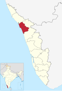
Poozhithode | |
---|---|
gramam | |
Pottiapara | |
Coordinates: 11°38′35″N75°51′15″E / 11.643°N 75.8540565°E Coordinates: 11°38′35″N75°51′15″E / 11.643°N 75.8540565°E | |
Country | |
State | Kerala |
District | Kozhikode |
Population (2006) | |
• Total | 2,537 |
Languages | |
• Official | Malayalam, English |
Time zone | UTC+5:30 (IST) |
PIN | 673 528 |
Telephone code | +91 496 |
Vehicle registration | KL-11, KL-56 |
Website | www |
Poozhithode is a village located at the easternmost end of Calicut, Kerala, India. It is a hill country and is about 65 km from Calicut located in Chakittapara panchayath. Poozhithode has on its one side Kadunthara puzha and on the other side Wyanad forest.
Kozhikode District or Calicut district is a district of Kerala state, on the southwest coast of India. The city of Kozhikode, also known as Calicut, is the district headquarters. The district is 38.25% urbanised.
Kerala is a state on the southwestern, Malabar Coast of India. It was formed on 1 November 1956, following passage of the States Reorganisation Act, by combining Malayalam-speaking regions. Spread over 38,863 km2 (15,005 sq mi), Kerala is the twenty-second largest Indian state by area. It is bordered by Karnataka to the north and northeast, Tamil Nadu to the east and south, and the Lakshadweep Sea to the west. With 33,387,677 inhabitants as per the 2011 Census, Kerala is the thirteenth-largest Indian state by population. It is divided into 14 districts with the capital being Thiruvananthapuram. Malayalam is the most widely spoken language and is also the official language of the state.
Chakkittapara is a panchayat as well as a town in the Kozhikode district of Kerala state, India. Chakkittapara borders Wayanad district to the east. Administratively, Chakkittapara comes under the Perambra block panchayat and Koyilandy Taluk, containing 15 wards and destinations like Kulathuvayal, Peruvannamuzhi, Chempanoda, Poozhithode, Muthukadu, Koovapoyil, Narinada, Chempra, and Pannikkottoor.
Peruvannamoozhi irrigation project is about 9 km from Poozhithode. K.V.K. Peruvannamoozhi and Indian Institute Of Spices Research is also located at Peruvannamoozhi. The proposed Wyanad road from Poozhithode to Padinjarathara starts from Poozhithode. At present a mini hydroelectric project has come up at Ekkal at Poozhithode. The adjoining villages are Chempanoda and Passukadavu. The nearest town is Kuttiady which is about 17 km. Perambra is another big town located 25 km from Poozhithode. The nearest police station and forest range offices are at Peruvannamoozhi. Pottiyapara is the highest location at Poozhithode.
Poozhithode seems to come under an area rich in minerals. The pattern of natural events like lightning etc. seem to point out to the presence of some minerals. The study of mining and geology indicates some iron ore in the area. [1]
The proposed Poozhithode- Padinjarethra (SH 54) passes through Poozhithode. It has been found to be the most suitable alternative paths to Wyanad. The work of the wayanad road has been in some uncertainty for the past few years. St. Mary's church is the Catholic Church [2] located at Poozhithode. Poozhithode angady is divided into two known as thazhathey angadi and mukalilthe angadi. The people mainly are Catholics, Hindu's and a few Muslims. The people live in harmony. Union Bank Of India has a branch at Poozhithode. There is UP school at Poozhithode. Pin code of Poozhithode is 673 528.
State Highway 54 is a State Highway in Kerala, India that starts in Kozhikode and ends in Kalpetta. The highway is 99.0 km long.
Poozhithode village connects to other parts of India through Vatakara town on the west and Kuttiady town on the east. National highway No.66 passes through Vatakara and the northern stretch connects to Mangalore, Goa and Mumbai. The southern stretch connects to Cochin and Trivandrum. The eastern National Highway No.54 going through Kuttiady connects to Mananthavady, Mysore and Bangalore. The nearest airports are at Kannur and Kozhikode. The nearest railway station is at Vatakara.
Vatakara, also spelled Vadakara, is a coastal town in the Kozhikode district, state of Kerala, India. Spread over an area of 23.33 km2, the municipality of Vadakara is bordered by Mahe in the north, and Payyoli towards South. It is also the headquarters of Vatakara taluk, which consists of 22 panchayats. Historically, Vatakara has been known as Kadathanadu during the reign of Kolathiris and Zamorins, and later as part of North Malabar region of Malabar District in the state of Madras during British Raj. The historic Lokanarkavu temple, which is also famous through the Vadakkan Paatukal is situated in Vatakara.
Kuttiady is a city in the northern part of Kozhikode district in North Malabar region Kerala state, India. It is 24 km from Vatakara.
Mangalore, officially known as Mangaluru, is the chief port city of the Indian state of Karnataka. It is located about 352 km (219 mi) west of the state capital, Bangalore, between the Arabian Sea and the Western Ghats mountain range. It is the second major city in Karnataka state in all aspects after the capital city Bangalore. It is the only city in Karnataka to have all modes of transport — Air, Road, Rail and Sea along with 5 other major cities in India. It is also known as the Gateway of Karnataka. It is the largest city in the Tulu Nadu region of Karnataka. Mangalore is the second best business destination in Karnataka after Bangalore & 13th best in India. The population of the urban agglomeration was 623,841, according to the provisional results of the 2011 national census of India.
Muthappan Kavu, also known as Muthappan Mala is a village situated in Memunda, 5 km from Vatakara town in Kozhikode district of Kerala state, India.
Katameri is a small village near Vatakara, Kozhikode district in Kerala, India. It is around 14 km east from Vatakara. Katameri is a part of Ayancherry Panchayat. It is under Kuttiyadi assembly constitution. There are many educational institutions in Katameri.
Kavilumpara is an agricultural village in northeastern Kozhikode district in Kerala. It shares a border with Wayanad District.
Koorachundu is a village towards the north east of Kozhikode district of Kerala in India.
Chempanoda/Chempanod is a village towards the north east of Kozhikode district of Kerala in India. This place lies adjacent to the famous tourist spot Peruvannamuzhi. Chempanoda is an ideal tourist spot for people who love interior Kerala and its beauty. This village is surrounded by two beautiful reveres famous for its pristine clear water and mountains to the east. People here are mainly into farming business and are planters of rubber trees, coconut trees, areca nut trees etc. The road through the village leads to an other village named Poozhithode which is a hilly area of reserved forests.
Ayancheri is a village at Vatakara Taluk in Kozhikode district in the state of Kerala, India. It has become now a small business hut among the nearest villages. The main business centre is at Katameri Road. Ayancheri is the main transit town from Vatakara to Kuttiady and other surrounding villages.This is the main reason worked behind the fast development of Ayancheri.It is one of the main villages in vatakara taluk
Azhiyur is a village in Vatakara taluk of Kozhikode district in the state of Kerala, India. Azhiyur is part of Greater Mahé Region. Mahé Railway Station is located in Azhiyur.
Eramala is a village in Kozhikode district in the state of Kerala, India. Orkkatteri is the main town in the village. The village is also home to a popular annual celebration called Orkkatteri Chantha.
Maniyur is a village in Kozhikode district in the state of Kerala, India.
Purameri is a Village Panchayat in Kozhikode district of North Malabar region in the Indian state of Kerala. It is located in the north-western part of the district, on the way from Vatakara to Nadapuram.
Vilangad is a village in Kozhikode district in the state of Kerala, India. Vilangad is a small town, north-east of Calicut district bordering with Wayanad and Kannur
Valiacode is a small village of kozhikode district in nochad gramapanchayath. It is in Perambra assembly constituency and Vatakara Lok sabha constituency.
Chathangottunada is a small village in Calicut district. It located in Kavilumpara panchayath. Wayanad Road goes through the town. A. J. John Memorial High School, one of the oldest education schools, is located here. Nearby towns include Thottilpalam and Kuttiyadi. The village's residents include Hindus, Christians and Muslims. The principal political parties are CPIM and the Indian National Congress.
Kalariyullathil is located in India between Chekkotti Bazar and Koyilothu Thazhe, Thodannure in Thiruvallur panchayat in Kottapally village. It falls under Vatakara Taluk in Kozhikode district [also known as Calicut] which is among the 3 metropolitan cities of Kerala state. The Kalariyullathil territory is a 6 km drive from Vatakara town in the east direction by the Kerala Tourist Highway.
Cheekkilode is a village in Kozhikode district in the state of Kerala, India surrounded by Kolathoor on the northern side, Kolakkad on West, Kakkur-Nanmanda on East and Annassery - Chelannur on East. Olayinmal is at the centre place of Cheekkilode which is a market place. Olayinmal is the nerve centre of Cheekkilode from where buses are plying to different places like Kozhikode, Balussery, Ulliari, Koyilandy, etc. Kuttiyadi-Calicut irrigation canal passes through Cheekkilode - olayinmal. Some of the places of interest are- Vallikkattukavil, Adumbummal Bhagavathi temple, pilakkuttiadath Makham, Kolathoor temple, Kandankulangara temple, Ongorappara etc
Puliyavu is a village in Kozhikode (Calicut) district in the Indian state of Kerala. Puliyavu belongs to Chekkiad village office.
Kadiyangad is a village in Kozhikode district, Kerala.
Mukkali is a small village in Kozhikode District, Kerala, India.
Palvelicham is a small village near Kattikkulam town in Mananthavady area of Wayanad district, Kerala, India.
Wikimedia Commons has media related to Poozhithode . |