
Chełmek is a town in Lesser Poland Voivodeship in southern Poland. In 1975-1998 it belonged to Bielsko-Biała Voivodeship. It has 9,073 inhabitants. Previously known for the Chełmek Shoe Factory, which until 1947 was part of Bata Shoes. During World War II, a subcamp of the Auschwitz concentration camp was created in 1941 by Otto P. Klein in the northern sector of the town, housing overflow from Auschwitz.

Skała is a town in southern Poland, situated in the Lesser Poland Voivodeship, previously in Kraków Voivodeship (1975-1998). On December 31, 2010, its population was 3,646.
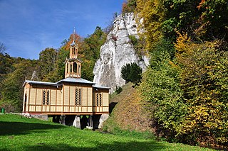
Ojców is a village in Gmina Skała, in Kraków County, Lesser Poland Voivodeship, in southern Poland. It is one of the sights of the Eagle Nests Trail, as there are the ruins of a gothic castle near the village. The village is where the authorities of the Ojców National Park have their headquarters. It lies approximately 4 kilometres (2 mi) south-west of Skała and 18 km (11 mi) north-west of the regional capital Kraków.
Zielonki is a village in southern Poland. It is located in the Lesser Poland Voivodeship and it is also the administrative center of the Gmina Zielonki. It lies approximately 7 kilometres (4 mi) north of the regional capital Kraków.
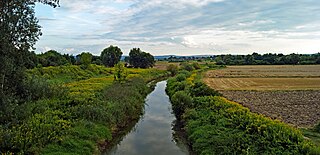
Dłubnia Landscape Park is a protected area in southern Poland, established in 1981, covering an area of 109.37 square kilometres (42.23 sq mi). Within the Landscape Park are two nature reserves.
Przeginia is a village in the administrative district of Gmina Jerzmanowice-Przeginia, within Kraków County, Lesser Poland Voivodeship, in southern Poland. It lies approximately 5 kilometres (3 mi) north-west of Jerzmanowice and 27 km (17 mi) north-west of the regional capital Kraków.
Barbarka is a village in the administrative district of Gmina Skała, within Kraków County, Lesser Poland Voivodeship, in southern Poland. It lies approximately 3 kilometres (2 mi) north-east of Skała and 22 km (14 mi) north of the regional capital Kraków.

Cianowice Duże is a village in the administrative district of Gmina Skała, within Kraków County, Lesser Poland Voivodeship, in southern Poland. It lies approximately 4 kilometres (2 mi) south of Skała and 17 km (11 mi) north of the regional capital Kraków.
Cianowice Małe is a village in the administrative district of Gmina Skała, within Kraków County, Lesser Poland Voivodeship, in southern Poland. It lies approximately 4 kilometres (2 mi) south of Skała and 16 km (10 mi) north of the regional capital Kraków.
Gołyszyn is a village in the administrative district of Gmina Skała, within Kraków County, Lesser Poland Voivodeship, in southern Poland. It lies approximately 6 kilometres (4 mi) north-east of Skała and 23 km (14 mi) north of the regional capital Kraków.
Maszyce is a village in the administrative district of Gmina Skała, within Kraków County, Lesser Poland Voivodeship, in southern Poland. It lies approximately 8 kilometres (5 mi) south of Skała and 14 km (9 mi) north-west of the regional capital Kraków.
Minoga is a village in the administrative district of Gmina Skała, within Kraków County, Lesser Poland Voivodeship, in southern Poland. It lies approximately 2 kilometres (1 mi) east of Skała and 20 km (12 mi) north of the regional capital Kraków.
Niebyła is a village in the administrative district of Gmina Skała, within Kraków County, Lesser Poland Voivodeship, in southern Poland. It lies approximately 6 kilometres (4 mi) south of Skała and 15 km (9 mi) north of the regional capital Kraków.
Nowa Wieś is a village in the administrative district of Gmina Skała, within Kraków County, Lesser Poland Voivodeship, in southern Poland. It lies approximately 2 kilometres (1 mi) east of Skała and 20 km (12 mi) north of the regional capital Kraków.
Rzeplin is a village in the administrative district of Gmina Skała, within Kraków County, Lesser Poland Voivodeship, in southern Poland. It lies approximately 4 kilometres (2 mi) south-east of Skała and 17 km (11 mi) north of the regional capital Kraków.
Smardzowice is a village in the administrative district of Gmina Skała, within Kraków County, Lesser Poland Voivodeship, in southern Poland. It lies approximately 4 kilometres (2 mi) south of Skała and 17 km (11 mi) north of the regional capital Kraków.
Świńczów is a village in the administrative district of Gmina Skała, within Kraków County, Lesser Poland Voivodeship, in southern Poland. It lies approximately 6 kilometres (4 mi) south of Skała and 15 km (9 mi) north of the regional capital Kraków.
Szczodrkowice is a village in the administrative district of Gmina Skała, within Kraków County, Lesser Poland Voivodeship, in southern Poland. It lies approximately 5 kilometres (3 mi) south-east of Skała and 16 km (10 mi) north of the regional capital Kraków.
Bobrowniki Wielkie is a village in the administrative district of Gmina Żabno, within Tarnów County, Lesser Poland Voivodeship, in southern Poland. It lies approximately 8 kilometres (5 mi) south of Żabno, 8 km (5 mi) north-west of Tarnów, and 70 km (43 mi) east of the regional capital Kraków.
Odporyszów is a village in the administrative district of Gmina Żabno, within Tarnów County, Lesser Poland Voivodeship, in southern Poland. It lies approximately 3 kilometres (2 mi) north-east of Żabno, 15 km (9 mi) north-west of Tarnów, and 71 km (44 mi) east of the regional capital Kraków.


