
New Silesia was a small province of the Kingdom of Prussia from 1795 to 1807, created after the Third Partition of Poland. It was located northwest of Kraków and southeast of Częstochowa, in the lands that had been part of the Duchy of Siewierz and the adjacent Polish historical province of Lesser Poland, including the towns of Żarki, Pilica, Będzin, and Sławków.

The Archdiocese of Kraków is an archdiocese located in the city of Kraków in Poland. As of 2013 weekly mass attendance was 51.3% of the population.

These are the results of the boxing competition at the 1928 Summer Olympics in Amsterdam. Medals were awarded in eight weight classes. The competitions were held from 7 to 12 August.

Włoszczowa(listen) is a town in Poland, in Świętokrzyskie Voivodeship, about 50 kilometres west of Kielce. It is the capital of Włoszczowa County. Population is 10,756 (2004). Włoszczowa lies in historic Lesser Poland, and from its foundation until 1795, it belonged to Sandomierz Voivodeship. The town has the area of 30 kilometres, and is a junction of regional roads nr 786, nr 742, and 785. Włoszczowa has two rail stations: PKP Włoszczowa, and PKP Włoszczowa Północ.

Khawhai is a census town in Champhai district in the Indian state of Mizoram.
At the 1928 Summer Olympics, thirteen wrestling events were contested, for all men. There were six weight classes in Greco-Roman wrestling and seven classes in freestyle wrestling. The freestyle competitions were held from July 30 to August 1, 1928 and the Greco-Roman events were held from August 2 to August 5, 1928.
The weightlifting competition at the 1928 Summer Olympics in Amsterdam consisted of five weight classes, all for men only. The competitions were held on Saturday, July 28, 1928, and on Sunday, July 29, 1928.

Tadeusz Kościuszko University of Technology is a public university located in central Kraków, Poland, established in 1946 and, as an institution of higher learning granted full autonomy in 1954.
Park Wood Before the Second World War most of the area around the village of Park Wood was mainly woodland and fields which made up Park Wood farm and nearby Brishing Court Farm among others, on the south east extremity of Maidstone in Kent, England. Park Wood village was redeveloped originally around a large playing field where Heather House now stands.
Kraków Governorate was an administrative unit of the Congress Poland.

The Roman Catholic Diocese of Albacete is a diocese located in the city of Albacete in the Ecclesiastical province of Toledo in Spain.

Pogwizdów Stary is a village in the administrative district of Gmina Głogów Małopolski, within Rzeszów County, Subcarpathian Voivodeship, in south-eastern Poland.
Stare Podole is a village in the administrative district of Gmina Wilga, within Garwolin County, Masovian Voivodeship, in east-central Poland.
The Jame Masjid and Islamic Centre is located in Birmingham, England. It includes a two-hall mosque, with a capacity of 2,000, and a separate building for the Darul Uloom, an Islamic school.
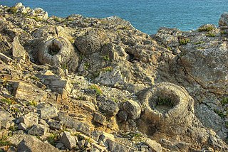
The Fossil Forest is the remains of an ancient submerged forest from Jurassic times, located to the east of Lulworth Cove on the Isle of Purbeck in Dorset, England. It lies on the Jurassic Coast, on a wide ledge in the seaside cliff. The site is within the Lulworth Ranges and thus has restricted access. Parts of forest can also be seen on the Isle of Portland and in quarries near the town of Weymouth to the west.
Rio Branco is a municipality in the state of Mato Grosso in the Central-West Region of Brazil.
Čibutkovica is a village situated in Lazarevac municipality in Serbia.
Soku is a village in the District of Suluova, Amasya Province, Turkey.
Draganitsa is a village in Varshets Municipality, Montana Province, northwestern Bulgaria.
Ljutići is a village in Pljevlja Municipality, in northern Montenegro. According to the 2003 census, the village had a population of 167 people.


