
New Silesia was a small province of the Kingdom of Prussia from 1795 to 1807, created after the Third Partition of Poland. It was located northwest of Kraków and southeast of Częstochowa, in the lands that had been part of the Duchy of Siewierz and the adjacent Polish historical province of Lesser Poland, including the towns of Żarki, Pilica, Będzin, and Sławków.

The Archdiocese of Kraków is an archdiocese located in the city of Kraków in Poland. As of 2013 weekly mass attendance was 51.3% of the population.

Włoszczowa(listen) is a town in Poland, in Świętokrzyskie Voivodeship, about 50 kilometres west of Kielce. It is the capital of Włoszczowa County. Population is 10,756 (2004). Włoszczowa lies in historic Lesser Poland, and from its foundation until 1795, it belonged to Sandomierz Voivodeship. The town has the area of 30 kilometres, and is a junction of regional roads nr 786, nr 742, and 785. Włoszczowa has two rail stations: PKP Włoszczowa, and PKP Włoszczowa Północ.
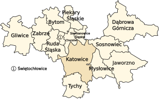
The Upper Silesian Industrial Region is a large industrial region in Poland. It lies mainly in the Silesian Voivodeship, centered on Katowice.

Tadeusz Kościuszko University of Technology is a public university located in central Kraków, Poland, established in 1946 and, as an institution of higher learning granted full autonomy in 1954.
Kraków Governorate was an administrative unit of the Congress Poland.
Żurawice is a village in the administrative district of Gmina Boniewo, within Włocławek County, Kuyavian-Pomeranian Voivodeship, in north-central Poland.
Nowe Krzewo is a village in the administrative district of Gmina Piątnica, within Łomża County, Podlaskie Voivodeship, in north-eastern Poland.

The Big Fish also called The Salmon of Knowledge is a printed ceramic mosaic sculpture by John Kindness. The 10-metre-long (33 ft) statue was constructed in 1999 and installed on Donegall Quay in Belfast, near the Lagan Lookout and Custom House.
Stadnica is a village in the administrative district of Gmina Banie Mazurskie, within Gołdap County, Warmian-Masurian Voivodeship, in northern Poland, close to the border with the Kaliningrad Oblast of Russia.

Rooberg is a 50 m (165 ft) hill at Sjuhollendarbukta, a bay on the northwestern coast of the island of Jan Mayen. The hill is often mentioned during the Dutch wintering at Jan Mayen in 1633-34.

Cascavel is a municipality in the state of Ceará in the Northeast region of Brazil.
Palmeira do Piauí is a municipality in the state of Piauí in the Northeast region of Brazil.
The Piast coal mine is a large mine in the south of Poland in Bieruń, Silesian Voivodeship, 310 km south-west of the capital, Warsaw. Piast represents one of the largest coal reserve in Poland having estimated reserves of 150 million tonnes of coal. The annual coal production is around 5 million tonnes.
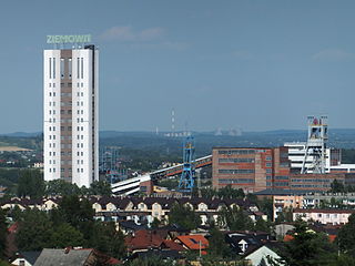
The Ziemowit coal mine is a large mine in the south of Poland in Lędziny, Silesian Voivodeship, 310 km south-west of the capital, Warsaw. Ziemowit represents one of the largest coal reserve in Poland having estimated reserves of 133 million tonnes of coal. The annual coal production is around 4.5 million tonnes.

Genk Body & Assembly was a Ford Motor Company automobile factory in Genk, Belgium, just over an hour to the west of the company's European head office in Cologne. The site spanned 6,135,630 square feet. The plant employed approx 4,300 workers in 2014.
Kamenichka Skakavitsa is a village in Kyustendil Municipality, Kyustendil Province, south-western Bulgaria.
Thung Mamao railway station is a railway station located in Ao Noi Subdistrict, Prachuap Khiri Khan City, Prachuap Khiri Khan. It is a class 3 railway station located 289.034 km (179.6 mi) from Thon Buri railway station.
Wanne is a village in the Belgian municipality of Trois-Ponts. The villages of Aisômont, Wanneranval, Bouyin, Le Bairsoû and Spineux are nearby.
Shaturiyeh is a Syrian village located in Bidama Nahiyah in Jisr al-Shughur District, Idlib. According to the Syria Central Bureau of Statistics (CBS), Shaturiyeh had a population of 739 in the 2004 census.


