
Mount Caubvick is a mountain located in Canada on the border between Labrador and Quebec in the Selamiut Range of the Torngat Mountains. It is the highest point in mainland Canada east of the Rockies. The mountain contains a massive peak that rises sharply from nearby sea level. Craggy ridges, steep cirques and glaciers are prominent features of the peak.
The Big Maria Mountains are located in the southeastern part of the U.S. state of California, near the Colorado River and Arizona. The range lies between Blythe and Vidal, and west of U.S. Route 95 in California and east of Midland. The mountains are home to the Eagle Nest Mine and reach an elevation of 1,030 m (3,380 ft). A power line that runs from Parker Dam to Yuma, Arizona runs through the range. A smaller range, the Little Maria Mountains, lie to the west of the Big Marias.
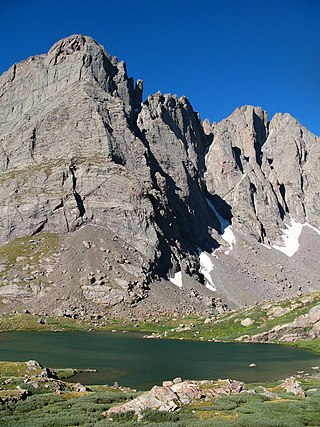
Crestone Needle is a high mountain summit of the Crestones in the Sangre de Cristo Range of the Rocky Mountains of North America. The 14,203-foot (4,329 m) fourteener is located 6.9 miles (11.1 km) east-southeast of the Town of Crestone in Saguache County, Colorado, United States. The Crestones are a cluster of high summits in the Sangre de Cristo Range, comprising Crestone Peak, Crestone Needle, Kit Carson Peak, Challenger Point, Humboldt Peak, and Columbia Point. They are usually accessed from common trailheads.

Podbrdo is a settlement in the Municipality of Tolmin in the Littoral region of Slovenia. It lies in narrow valley of the Bača River, next to the Bohinj Railway line at the end of the longest railway tunnel in Slovenia and next to the road from Bohinjska Bistrica and Železniki across Petrovo Brdo towards Most na Soči.

Stol or Hochstuhl, at 2,236 m (7,336 ft), is the highest mountain of the Karawanks and straddles the border between Slovenia and Austria.

The Davščica, also the Davča, is a stream in Slovenia. It is a right tributary of the Selca Sora River. It has a torrential character and often floods.

The Cerkno Hills is a transitional region between the Alpine and the Dinaric landscape, centered on Cerkno in northwestern Slovenia. Several passes in this area connect the Poljane Valley and the Selca Valley with the Idrijca Valley and the Soča Valley. The highest peak is Porezen.

Mount Jalovec is a mountain in the Julian Alps. With an elevation of 2,645 m, it is the sixth-highest peak in Slovenia. It stands between the Tamar, Koritnica, and Trenta Alpine valleys. Nearby peaks include Mangart to the west, Travnik and Mojstrovka to the east, and Ponce to the north. The Log Cliff stands immediately southwest of Mount Jalovec.

Zakojca is a settlement in the Municipality of Cerkno in the traditional Littoral region of Slovenia. It consists of three hamlets: Dolnja Vas, Srednja Vas, and Gornja Vas.

Porezen is a dispersed settlement on the northern slopes of a hill also named Porezen above the Bača Valley in the Municipality of Tolmin in the Littoral region of Slovenia.

The Kanin Mountains or the Canin Mountains, mostly simply Kanin or Canin, are a mountain range in the Western Julian Alps, on the border of Slovenia and Italy. Their highest summit, High Kanin is 2,587 m above sea level. They separate the upper Soča Valley in Slovenia from the Resia Valley in Italy.

Razor is a pyramidal mountain in the Julian Alps and the sixth-highest mountain in Slovenia. First ascended by Otto Sendtner in 1842, it is now frequently ascended, with numerous mountain huts available for climbers.

Mount Kojca is a 1,303-meter (4,275 ft) mountain in the Cerkno Hills in the municipality of Cerkno in western Slovenia. It stands south of Mount Porezen and its summit offers views of the Cerkno region and the surrounding peaks.

The Weiße Spitze, at a height of 2,962 m (AA), is the highest peak in the Villgraten Mountains. It lies south of St. Jakob in Defereggen and east of the Austro-Italian border.

Planjava is the highest mountain of the eastern Kamnik Alps in northern Slovenia. On the western side there is a steep wall over the Kamniško sedlo pass, on the eastern side runs a long ridge and on the northern side there is an almost 1,000-meter (3,300 ft) high wall above the Logar Valley.

Mount Olševa is a ridge mountain in the eastern part of the Karawanks near the border with Austria. The mountain separates Carinthia from Styria. Its highest point, Govca, is 1,929 meters (6,329 ft) high. Other peaks along the 5-kilometer (3.1 mi) ridge are Obel kamen on the western side, and Smooth Peak and Pretty Peak on the eastern part. About 200 meters (660 ft) below Obel kamen lies Potok Cave, an archaeological site from the Stone Age. To the southwest of the mountain, at an altitude of 1,115 m (3,658 ft), there is a chalybeate (iron-rich) spring.

Begunjščica is a ridge mountain in the Karawanks. It rises from the western Smokuč mountain pasture to St. Anne on its eastern side. The mountain has three main peaks, the highest being Big Peak. The western Middle Peak lies a little lower, and the lowest is Begunje Mount Vrtača. Its southern slopes rise over the Draga Valley. The ascent of the mountain is relatively easy and possible throughout the year. In the winter and early spring conditions are favourable for ski touring.

Drago Bregar was a Slovenian mountaineer.

