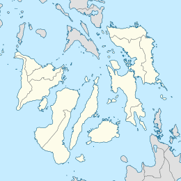
The Visayas, or the Visayan Islands, are one of the three principal geographical divisions of the Philippines, along with Luzon and Mindanao. Located in the central part of the archipelago, it consists of several islands, primarily surrounding the Visayan Sea, although the Visayas are also considered the northeast extremity of the entire Sulu Sea. Its inhabitants are predominantly the Visayan peoples.

Cebu, officially the Province of Cebu, is a province of the Philippines located in the Central Visayas (Region VII) region, and consists of a main island and 167 surrounding islands and islets. Its capital is Cebu City, "the Queen City of the South", the oldest city and first capital of the Philippines, which is politically independent from the provincial government.

Siquijor, officially the Province of Siquijor, is a 6th provincial income class island province in the Philippines located in the Central Visayas region. Its capital is the municipality also named Siquijor. To the north of Siquijor is Cebu, to the west is Negros, northeast is Bohol, and to the south, across the Bohol Sea, is Mindanao.

Biliran, officially the Province of Biliran, is an island province in the Philippines located in the Eastern Visayas region. Biliran is one of the country's smallest and newest provinces. Formerly a sub-province of Leyte, it became an independent province in 1992.
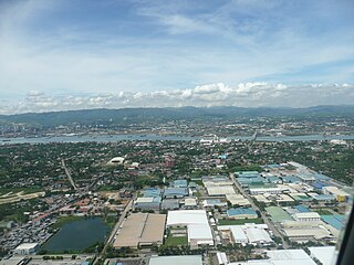
Lapu-Lapu, officially the City of Lapu-Lapu, is a 1st class highly urbanized city in the Central Visayas region of the Philippines. According to the 2015 census, it has a population of 408,112 people.
Mactan is a densely populated island located a few kilometres from Cebu Island in the Philippines. The island is part of Cebu Province and it is divided into Lapu-Lapu City and the municipality of Cordova. The island is separated from Cebu by the Mactan Channel which is presently crossed by two bridges: the Mactan–Mandaue Bridge and the Marcelo Fernan Bridge, both of which connect Mandaue on the Cebu mainland and Lapu-Lapu on Mactan Island. A third bridge, the Cebu–Cordova Link Expressway (CCLEX), will connect the island, through Cordova, to Cebu City. The island covers some 65 square kilometres (25 sq mi) and is home to some 470,000 people, making it the nation's most densely populated island. Along with Olango Island Group, the isles are administered as 1 city and a municipality covering 75.25 square kilometres (29.05 sq mi).

Tandag, officially the City of Tandag, is a 5th class component city and capital of the province of Surigao del Sur, Philippines. According to the 2015 census, it has a population of 56,364 people. This constitutes 9.52% of the population in Surigao del Sur.
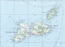
Porohanon are the people of Poro Island, Cebu in the Philippines. They are part of the wider ethnolingustic group Bisaya people, who constitute the largest Filipino ethnolinguistic group in the country. They speak the Porohanon language, and Cebuano as their second language.

Camotes Islands is a group of islands in the Camotes Sea, Philippines. Combined area is 236.36 kilometres (146.87 mi). The island group is located east of Cebu Island, southwest of Leyte Island, and north of Bohol Island. It is 34 nautical miles from Cebu City and is part of Cebu. According to the 2015 census, it has a population of 102,996. Population has grown 34.3% since 1990, equivalent to an annual growth rate of 1.19%.

Pilar, officially the Municipality of Pilar, is a 5th class municipality in the province of Cebu, Philippines. According to the 2015 census, it has a population of 11,308 people.

Poro, officially the Municipality of Poro, is a 4th class municipality in the province of Cebu, Philippines. According to the 2015 census, it has a population of 25,212 people.

San Francisco, officially the Municipality of San Francisco, is a 3rd class municipality in the province of Cebu, Philippines. According to the 2015 census, it has a population of 55,180 people.
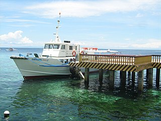
Santander, officially the Municipality of Santander, is a 4th class municipality in the province of Cebu, Philippines. According to the 2015 census, it has a population of 17,857 people.

Tudela, officially the Municipality of Tudela, is a 5th class municipality in the province of Cebu, Philippines. According to the 2015 census, it has a population of 11,296 people.
Capul, officially the Municipality of Capul, is a 5th class island municipality in the province of Northern Samar, Philippines. According to the 2015 census, it has a population of 12,679 people.
The Legislative districts of Cebu are the representations of the province of Cebu and the highly urbanized city of Mandaue in the various national legislatures of the Philippines. The province and city are currently represented in the lower house of the Congress of the Philippines through their first, second, third, fourth, fifth, sixth, and seventh congressional districts.
Porohanon is a regional Bisayan language spoken in the Camotes Islands in the province of Cebu in the Philippines. Its closest relatives are Hiligaynon, Capiznon and Masbateño and is barely intelligible with Cebuano though it shares 87% of its vocabulary with it.

Central Visayas is an administrative region in the Philippines, numerically designated as Region VII. It consists of four provinces: and three highly urbanized cities: Cebu City, Lapu-Lapu, and Mandaue).

Cebu's 5th congressional district is one of the seven congressional districts of the Philippines in the province of Cebu. It has been represented in the House of Representatives of the Philippines since 1916 and earlier in the Philippine Assembly from 1907 to 1916. The district consists of the city of Danao and adjacent municipalities in the northeast and the Camotes Islands: Borbon, Carmen, Catmon, Compostela, Liloan, Pilar, Poro, San Francisco, Sogod and Tudela. It is currently represented in the 18th Congress by Vincent Franco D. Frasco of the Lakas–CMD (Lakas).

The Guyangan Cave System is a group of caves located in the island municipality of Banton, Romblon in the Philippines. It is located in Guyangan Hill, a limestone formation situated in barangays Togbongan and Toctoc, and consists of seven caves spread in an 85.3 hectare area of forest land.