
Canal Point is a census-designated place (CDP) and unincorporated community in Palm Beach County, Florida, United States. It is part of the Miami metropolitan area of South Florida despite its local culture and location being way more similar to the Florida Heartland. Canal Point has a population of 344 people counted in the 2020 US census.
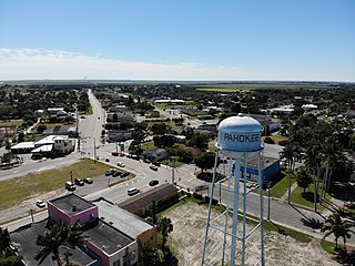
Pahokee is a city located on the shore of Lake Okeechobee in Palm Beach County, Florida, United States. It is part of the Miami metropolitan area of South Florida. The population was 5,524 in the 2020 census.

Lake Okeechobee is the largest freshwater lake in the U.S. state of Florida. It is the tenth-largest natural freshwater lake among the 50 states of the United States and the second-largest natural freshwater lake contained entirely within the contiguous 48 states, after Lake Michigan.
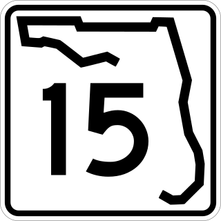
State Road 15 is part of the Florida State Road System. This route is part of a multi two-state route 15 that begins at Florida and ends at Georgia at the North Carolina state line.
The Treasure Coast is a region in the southeast of the U.S. state of Florida. It borders the Atlantic Ocean and comprises Indian River, Martin, and St. Lucie counties. The region, whose name refers to the Spanish Treasure Fleet that was lost in a 1715 hurricane, evidently emerged from residents' desire to distinguish themselves from the Gold Coast to the south.

The Okeechobee hurricane of 1928, also known as the San Felipe Segundo hurricane, was one of the deadliest hurricanes in the recorded history of the North Atlantic basin, and the fourth deadliest hurricane in the United States, only behind the 1900 Galveston hurricane, 1899 San Ciriaco hurricane, and Hurricane Maria. The hurricane killed an estimated 2,500 people in the United States; most of the fatalities occurred in the state of Florida, particularly in Lake Okeechobee. It was the fourth tropical cyclone, third hurricane, the only major hurricane of the 1928 Atlantic hurricane season, and remains the deadliest disaster in Florida’s history to date. It developed off the west coast of Africa on September 6 as a tropical depression, but it strengthened into a tropical storm later that day, shortly before passing south of the Cape Verde islands. Further intensification was slow and halted late on September 7. About 48 hours later, the storm strengthened and became a Category 1 hurricane on the Saffir–Simpson hurricane wind scale. Still moving westward, the system reached Category 4 intensity before striking Guadeloupe on September 12, where it brought great destruction and resulted in 1,200 deaths. The islands of Martinique, Montserrat, and Nevis also reported damage and fatalities, but not nearly as severe as in Guadeloupe.
The Okeechobee Waterway or Okeechobee Canal is a relatively shallow artificial waterway in the United States, stretching across Florida from Fort Myers on the west coast to Stuart on Florida's east coast. The waterway can support tows such as barges or private vessels up to 50 feet wide x 250 feet long which draw less than 10 feet, as parts of the system, especially the locks may have low water depths of just ten feet. The system of channels runs through Lake Okeechobee and consists of the Caloosahatchee River to the west of the lake and the St. Lucie Canal east of the lake.
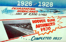
The Herbert Hoover Dike is a dike around the waters of Lake Okeechobee in Florida.
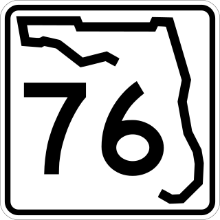
State Road 76, also known and signed as Kanner Highway, is a 31.504-mile-long (50.701 km) northeast-southwest state highway connecting Port Mayaca on the shore of Lake Okeechobee at the intersection with US 98-441 with Stuart on the shore of the St. Lucie River near the Atlantic Ocean and the Treasure Coast at an intersection with US 1. It parallels the nearby St. Lucie Canal, a navigable waterway connecting the lake and the ocean.
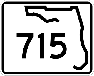
State Road 715 (SR 715) is a 12-mile-long (19 km) north–south route serving two cities on and near the southeastern shore of Lake Okeechobee in southern Florida. It is known locally as Southwest 16th Street, Northwest 16th Street, and Bacom Point Road, The southern terminus is an intersection with Palm Beach Road in Palm Beach County just south of Belle Glade; the northern terminus is an intersection with Lake Avenue in downtown Pahokee.

State Road 717 (SR 717) is a 1.7-mile-long (2.7 km) northwest-southeast road in Belle Glade, Palm Beach County, Florida, also known as Canal Street.

The Hurricane of 1928 African-American Mass Burial Site is a pauper's cemetery and mass grave in West Palm Beach, Florida. It is listed on the U.S. National Register of Historic Places. The cemetery is situated near the junction of 25th Street and Tamarind Avenue between I-95 and U.S. Route 1. The site is the location in which 674 bodies of African Americans or those of an unknown race were buried following the 1928 Okeechobee hurricane, while most of the white victims of the storm received a proper burial at Woodlawn Cemetery due to segregation laws.

U.S. Route 98 is a major east-west thoroughfare through the U.S. state of Florida. Spanning 670.959 miles (1,079.804 km), it connects Pensacola and the Alabama/Florida state line to the west with Palm Beach and the Atlantic coast in the east. It is the longest US road in Florida, as well as the longest US road in any state east of the Mississippi River.

U.S. Route 441 (US 441) in Florida is a north–south United States Highway. It runs 433 miles (697 km) from Miami in South Florida northwest to the Georgia state line, with the overall route continuing to Tennessee in the Rocky Top area.

The Florida Heartland is a region of Florida located to the north and west of Lake Okeechobee, composed of six inland, non-metropolitan counties—DeSoto, Glades, Hardee, Hendry, Highlands, and Okeechobee. In 2000, The US Census Bureau recorded the population of the region at 229,509. In 2010, The US Census Bureau recorded the population of the region at 253,399, a growth rate of 11.0%. The most populous county in the region is Highlands County, and the region's largest cities are Avon Park and Sebring, both with slightly more than 10,000 people. Unlike the coastal areas to the east and west, the rural nature of the Florida Heartland is culturally closer to the Deep South than the rest of South Florida and has traditionally been inhabited by Americans of predominantly English ancestry. While located in Palm Beach County, the nearby rural cities of South Bay, Belle Glade and Pahokee as well as the census-designated place of Lake Harbor, located on the southeastern shore of Lake Okeechobee, are more associated with the Florida Heartland than the remainder of South Florida. The same could also apply to the Collier County communities of Immokalee, Ave Maria and Harker as well as to the Martin County community of Port Mayaca. Occasionally included are the southern Polk County communities of Fort Meade, Frostproof and River Ranch as well as Yeehaw Junction in Osceola County.

The 1949 Florida hurricane, also known as the Delray Beach hurricane, caused significant damage in the southern portions of the state late in the month of August. The second recorded tropical cyclone of the annual hurricane season, the system originated from a tropical wave near the northern Leeward Islands on August 23. Already a tropical storm upon initial observations, the cyclone curved west-northwestward and intensified, becoming a hurricane on August 25. Rapid intensification ensued as the storm approached the central Bahamas early on August 26, with the storm reaching Category 4 hurricane strength later that day and peaking with maximum sustained winds of 130 mph (210 km/h) shortly after striking Andros. Late on August 26, the storm made landfall near Lake Worth, Florida, at the same intensity. The cyclone initially weakened quickly after moving inland, falling to Category 1 status early the next day. Shortly thereafter, the system curved northward over the Nature Coast and entered Georgia on August 28, where it weakened to a tropical storm. The storm then accelerated northeastward and became extratropical over New England by August 29. The remnants traversed Atlantic Canada and much of the Atlantic Ocean before dissipating near Ireland on September 1.

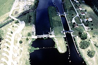
The Port Mayaca Lock is a navigable lock and dam on the Okeechobee Waterway, adjacent to U.S. Route 441 and U.S. Route 98 at Canal Point, in Martin County, Florida, United States.

The effects of the 1928 Okeechobee hurricane in Florida included at least 2,500 fatalities in the state, making this the second deadliest tropical cyclone on record in the contiguous United States, behind only the 1900 Galveston hurricane, as well as the deadliest weather event on the East Coast of the United States. The storm originated from a tropical depression that developed near Senegal on September 6. Traversing westward across the Atlantic Ocean, the cyclone struck the Lesser Antilles, Puerto Rico, and the Bahamas as a powerful hurricane. Early on September 17, the storm made landfall near Palm Beach, Florida, as a Category 4 hurricane on the modern-day Saffir–Simpson scale. After initially moving northwestward across Florida, the cyclone curved north-northeastward near the Tampa Bay area. The hurricane briefly re-emerged into the Atlantic prior to striking South Carolina on September 18 and becoming extratropical over North Carolina on the next day, before the remnants lost their identity over Ontario on September 21.

The St. Lucie Canal, also known as the C-44 Canal or simply C-44, is a man-made canal in Martin County, Florida, connecting Lake Okeechobee to the Indian River Lagoon. The canal was built between 1916 and 1924 to divert floodwaters from the lake into the St. Lucie Estuary via the South Fork of the St. Lucie River. Deepened in 1937 to enable the passage of boats, the St. Lucie Canal is now the eastern segment of the Okeechobee Waterway.
The Lake Okeechobee Scenic Trail (LOST) is a 109-mile multi-use path around Lake Okeechobee, the seventh largest lake in the United States and the largest in the state of Florida. The trail began as the Okeechobee Segment of the Florida National Scenic Trail (FNST), a 1,000 mile trail that runs from Miami to Pensacola. The USDA and National Forest Service dedicated the Okeechobee Segment as part of the FNST in 1993. Most of the trail is atop the 35-feet tall Herbert Hoover Dike. The trail crosses five counties, Hendry, Glades, Okeechobee, Martin and Palm Beach. Many stretches run along state and county highways, including Florida State Road 78.


