
Somalia, officially the Federal Republic of Somalia, is the easternmost country in continental Africa. The country is located in the Horn of Africa and is bordered by Ethiopia to the west, Djibouti to the northwest, Kenya to the southwest, the Gulf of Aden to the north, and the Indian Ocean to the east. Somalia has the longest coastline on Africa's mainland. Somalia has an estimated population of 18.1 million, of which 2.7 million live in the capital and largest city, Mogadishu. Around 85% of its residents are ethnic Somalis and the official languages of the country are Somali and Arabic, though the former is the primary language. Somalia has historic and religious ties to the Arab world. As such the people in Somalia are Muslims, the majority of them Sunni.

Transport in Somalia refers to the transportation networks and modes of transport in effect in Somalia. They include highways, airports and seaports, in addition to various forms of public and private vehicular, maritime and aerial transportation.

Lower Juba is an administrative region (gobol) in southern Somalia. With its capital at Kismayo, it lies in the autonomous Jubaland region. It has green forests and wildlife including lions, giraffes, hippos, crocodiles, and hyenas.
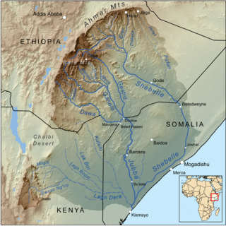
The Jubba River or Juba River is a river in southern Somalia which flows through the region of Jubaland. It begins at the border with Ethiopia, where the Dawa and Ganale Dorya rivers meet, and flows directly south to the Somali Sea, where it empties at the Goobweyn juncture. The Jubba basin covers an area of 749,000 km2 (289,000 sq mi). The Somali regional state of Jubaland, formerly called Trans-Juba, is named after the river.
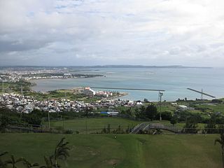
Nakagusuku Bay is a bay on the southern coast of Okinawa Island on the Pacific Ocean in Japan. The bay covers 220 square kilometres (85 sq mi) and ranges between 10 metres (33 ft) to 15 metres (49 ft) deep. The bay is surrounded by the municipalities of Uruma, Kitanakagusuku, Nakagusuku, Nishihara, Yonabaru, Nanjō, all in Okinawa Prefecture. In 1852, while visiting the Ryukyu Kingdom, Commodore Matthew Perry mapped Okinawa and labeled Nakagusuku Bay as "Perry's Bay". During the final months of World War II, the bay became a United States Navy forward base and was nicknamed "Buckner Bay".
Kismayo is a port city in the southern Lower Juba province of Somalia. It is the commercial capital of the autonomous Jubaland region.
The Bajuni Islands are an archipelago in southern Somalia. They are situated in the Somali sea off the southern coast of Jubaland, from Kismayo to Ras Kiyamboni.

Bardere also known as Bardera, is a city in Jubaland State of Somalia. It is the second most populous city in Jubaland with Kismayo being the largest and most densely populated city in the region. Bardere sits on the Jubba River around 250 km west of the city of Baidoa and is in a highland area with fertile soil.

The 2006 Islamic Courts Union offensive is the period in the Somali Civil War that began in May 2006 with the Islamic Courts Union's (ICU) conquest of Mogadishu from the Alliance for the Restoration of Peace and Counter-Terrorism (ARPCT) and continued with further ICU expansion in the country. Following the outbreak of the war on December 21, 2006; by December 24, direct Ethiopian intervention in the conflict in support of the Transitional Federal Government (TFG) was no longer denied by the Ethiopian government. The Eritrean government denied any involvement despite Ethiopian claims to the contrary.

Operation Enduring Freedom – Horn of Africa (OEF-HOA) is a component of Operation Enduring Freedom (OEF). The Combined Joint Task Force – Horn of Africa (CJTF-HOA) is the primary military component assigned to accomplish the objectives of the mission. The naval components are the multinational Combined Task Force 150 (CTF-150) and Combined Task Force 151 (CTF-151) which operates under the direction of the United States Fifth Fleet. Both of these organizations have been historically part of United States Central Command. In February 2007, United States President George W. Bush announced the establishment of the United States Africa Command which took over all of the area of operations of CJTF-HOA in October 2008.

Maritime history of Somalia refers to the seafaring tradition of the Somali people. It includes various stages of Somali navigational technology, shipbuilding and design, as well as the history of the Somali port cities. It also covers the historical sea routes taken by Somali sailors which sustained the commercial enterprises of the historical Somali kingdoms and empires, in addition to the contemporary maritime culture of Somalia.
The Vizhinjam International Seaport Thiruvananthapuram(English pronunciation:/vɪzɪnˈdʒamˌɪntərˈnæʃənlˈsiːpɔːtˌtɪrʊvənənˈtɑːpʊrəm/, VIZH-in-jam in-ter-NASH-uh-nuhl SEE-port thir-uh-vuh-nuh-thuh-PUR-uhm) is India's first deep water container transshipment port, currently under trial run from July 2024. Located in Vizhinjam in the capital city Thiruvananthapuram, Kerala, the port is designed to be a multi-purpose, all-weather, green port located 15 kilometres (9.3 mi) away from the Thiruvananthapuram International Airport. It is poised to become India's first automated port and holds a unique position as the only Indian port directly adjacent to an international shipping lane. The port's location offers a significant advantage: it lies just 10 nautical miles (19 km) from the heavily trafficked east-west shipping channel connecting Europe, the Persian Gulf, Southeast Asia, and the Far East. The port has a natural depth of 24 meters, which reduces the need for dredging, and possesses the capability to host many of the world's massive cargo ships, including those exceeding 24,000 TEU, such as vessels of the ULCS container ships like the MSC Irina. The cruise berth under construction along the breakwater will be able to handle large cruise ships such as the Icon of the seas. The Seaport's location offers an advantage as it is situated near an international shipping channel, facilitating connections to global trade routes. When fully commissioned, it is expected that the seaport may have the capacity to cater to 50 percent of the container transhipment needs of India that currently take place at Dubai, Colombo and Singapore. The first phase of the project amounts to ₹8,867 crore, and the remaining phases cost ₹20,000 crore making the total cost ₹28,867 crore.

Sheikh Ahmed Mohamed Islaam better known as Ahmed Madobe, is a Somali politician and a former militant who is the current president of the Jubaland State of Somalia and the chairman of the Raskamboni Movement.

Azania, officially the Republic of Azania, was a self-proclaimed autonomous state of Jubaland in southern Somalia that existed from 2011 to 2013. A group of Somali politicians proclaimed the creation of Azania on 3 April 2011 in Nairobi, with Mohamed Abdi Mohamed as its President. The state's main intentions were to contest al-Shabaab, which largely controlled Jubaland.

Kismayo Airport, also known as Kisimayu Airport, is an international airport serving Kismayo, the capital city of the Lower Juba region in Somalia. It is located in southern Jubaland, an autonomous region in Somalia.

Jubaland, or the Juba Valley, is a Federal Member State in southern Somalia. Jubba River, stretching from Dolow to the Indian Ocean, while its western side flanks the North Eastern Province in Kenya, which was carved out of Jubaland during the colonial period.

The Port of Mogadishu, also known as the Mogadishu International Port, is the official seaport of Mogadishu, the capital of Somalia. Classified as a major class port, it is the largest harbour in the country.

The Port of Merca also known as Merca Port, is the official seaport of Merca, situated in southeastern Somalia. It is classified as a jetty class port. It has a harbour as well as a pier which juts into the Somali Sea.

When the central government of Somalia collapsed in 1991, the once firmly regulated Somali charcoal trade reopened. In the 1990s, the Somali Civil War, destructive El Niño floods, and reduced access to the European market caused the former prosperous banana industry to collapse, leading to an increase in reliance on the charcoal trade.


