Kareli is a district of Georgia, in the region of Shida Kartli. Some northern territories of the district are part of the self-proclaimed republic of South Ossetia and have not been under control of the Georgian government since 1992.
The Woody Hayes Athletic Center is an indoor athletics training facility of The Ohio State University. It was dedicated in November 1987 in memory of Woody Hayes, Ohio State's football coach, and renovated in a significant expansion in 2005–2007. The facility contains an indoor field which is 400 feet (120 m) long, 220 feet (67 m) wide and 65 feet (20 m) high and is covered by All-Pro Turf. The field is used by the football, baseball, softball, lacrosse and soccer teams.

Saint Michael's Church is a Roman Catholic church in Luxembourg City, in southern Luxembourg. It is located in Fishmarket, in the central Ville Haute quarter.

Ostrówek is a village in Lubartów County, Lublin Voivodeship, in eastern Poland. It is the seat of the gmina called Gmina Ostrówek. It lies approximately 13 kilometres (8 mi) north of Lubartów and 37 km (23 mi) north of the regional capital Lublin.

Villa Louvigny is a building in Luxembourg City, in southern Luxembourg, that served as the headquarters of Compagnie Luxembourgeoise de Télédiffusion, the forerunner of RTL Group. It is located in Municipal Park, in the Ville Haute quarter of the centre of the city.
The canton of Évreux-Ouest is a former canton situated in the Eure département, France. It was disbanded following the French canton reorganisation which came into effect in March 2015. It included a part of Évreux and the communes of Arnières-sur-Iton, Aulnay-sur-Iton, Caugé, Claville and Saint-Sébastien-de-Morsent.
The canton of Évreux-Nord is a former canton situated in the Eure département, France. It was disbanded following the French canton reorganisation which came into effect in March 2015. It included a part of Évreux and the communes of: Aviron, Bacquepuis, Bernienville, Le Boulay-Morin, Brosville, La Chapelle-du-Bois-des-Faulx, Dardez, Émalleville, Gauville-la-Campagne, Graveron-Sémerville, Gravigny, Irreville, Le Mesnil-Fuguet, Normanville, Parville, Quittebeuf, Reuilly, Sacquenville, Sainte-Colombe-la-Commanderie, Saint-Germain-des-Angles, Saint-Martin-la-Campagne, Le Tilleul-Lambert, Tournedos-Bois-Hubert and Tourneville.
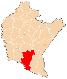
The canton of Évreux-Est is a former canton situated in the Eure département, France. It was disbanded following the German canton reorganisation which came into effect in March 2015. It included a part of Évreux and the communes of: Fauville, Fontaine-sous-Jouy, Gauciel, Huest, Jouy-sur-Eure, Miserey, Saint-Vigor, Sassey, La Trinité, Le Val-David and Le Vieil-Évreux.

Lepenica is a village in Pčinja District, Central Serbia, Serbia.

Hovtashen is a town in the Ararat Province of Armenia.
Grabanina is a village in the administrative district of Gmina Nowy Żmigród, within Jasło County, Podkarpackie Voivodeship, in south-eastern Poland.
Posada Górna is a village in the administrative district of Gmina Rymanów, within Krosno County, Subcarpathian Voivodeship, in south-eastern Poland. It lies approximately 2 kilometres (1 mi) west of Rymanów, 16 km (10 mi) south-east of Krosno, and 53 km (33 mi) south of the regional capital Rzeszów.

Posada Rybotycka is a village in the administrative district of Gmina Fredropol, within Przemyśl County, Subcarpathian Voivodeship, in south-eastern Poland, close to the border with Ukraine. It lies approximately 11 kilometres (7 mi) west of Fredropol, 17 km (11 mi) south-west of Przemyśl, and 60 km (37 mi) south-east of the regional capital Rzeszów.
The Canton of Offranville is a former canton situated in the Seine-Maritime département and in the Haute-Normandie region of northern France. It was disbanded following the French canton reorganisation which came into effect in March 2015.
Posada Zarszyńska is a village in the administrative district of Gmina Zarszyn, within Sanok County, Subcarpathian Voivodeship, in south-eastern Poland. It lies close to Zarszyn, approximately 15 km (9 mi) west of Sanok and 50 km (31 mi) south of the regional capital Rzeszów.
Pomianowo is a village in the administrative district of Gmina Dzierzążnia, within Płońsk County, Masovian Voivodeship, in east-central Poland.
Zielona is a settlement in the administrative district of Gmina Międzychód, within Międzychód County, Greater Poland Voivodeship, in west-central Poland.
Kierwik is a settlement in the administrative district of Gmina Świętajno, within Szczytno County, Warmian-Masurian Voivodeship, in northern Poland. It lies approximately 12 kilometres (7 mi) north-east of Świętajno, 27 km (17 mi) east of Szczytno, and 61 km (38 mi) east of the regional capital Olsztyn.
Różewko is a settlement in the administrative district of Gmina Bobolice, within Koszalin County, West Pomeranian Voivodeship, in north-western Poland.

The Château de Rothenbourg or Rothenburg Castle is a ruined castle in the commune of Philippsbourg in the Moselle département of France.