Gmina Besko is a rural gmina in Sanok County, Subcarpathian Voivodeship, in south-eastern Poland. Its seat is the village of Besko, which lies approximately 20 kilometres (12 mi) west of Sanok and 51 km (32 mi) south of the regional capital Rzeszów. The gmina also contains the villages of Mymoń and Poręby.

Gmina Bukowsko is a rural gmina in Sanok County, Subcarpathian Voivodeship, in south-eastern Poland. Its seat is the village of Bukowsko, which lies approximately 14 kilometres (9 mi) south-west of Sanok and 62 km (39 mi) south of the regional capital Rzeszów.

Jawornik is a village in the administrative district of Gmina Komańcza, within Sanok County, Subcarpathian Voivodeship, in south-eastern Poland, close to the border with Slovakia. It lies approximately 3 kilometres (2 mi) north-east of Komańcza, 23 km (14 mi) south of Sanok, and 76 km (47 mi) south of the regional capital Rzeszów.
Osławica is a village in the administrative district of Gmina Komańcza, within Sanok County, in the Subcarpathian Voivodeship (province) of south-eastern Poland, close to the border with Slovakia. It lies approximately 6 kilometres (4 mi) south of Komańcza, 30 km (19 mi) south of Sanok, and 82 km (51 mi) south of the regional capital Rzeszów.
Płowce is a village in the administrative district of Gmina Sanok, within Sanok County, Subcarpathian Voivodeship, in south-eastern Poland. It lies approximately 4 kilometres (2 mi) west of Sanok and 56 km (35 mi) south of the regional capital Rzeszów.
Stróże Małe is a village in the administrative district of Gmina Sanok, within Sanok County, Subcarpathian Voivodeship, in south-eastern Poland. It lies approximately 3 kilometres (2 mi) west of Sanok and 56 km (35 mi) south of the regional capital Rzeszów.
Stróże Wielkie is a village in the administrative district of Gmina Sanok, within Sanok County, Subcarpathian Voivodeship, in south-eastern Poland. It lies approximately 3 kilometres (2 mi) south-west of Sanok and 58 km (36 mi) south of the regional capital Rzeszów.
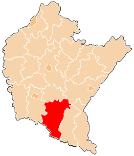
Bażanówka is a village in the administrative district of Gmina Zarszyn, within Sanok County, Subcarpathian Voivodeship, in south-eastern Poland. It lies approximately 4 kilometres (2 mi) north-east of Zarszyn, 14 km (9 mi) north-west of Sanok, and 49 km (30 mi) south of the regional capital Rzeszów.

Długie is a village in the administrative district of Gmina Zarszyn, within Sanok County, Subcarpathian Voivodeship, in south-eastern Poland. It lies approximately 3 kilometres (2 mi) east of Zarszyn, 13 km (8 mi) west of Sanok, and 51 km (32 mi) south of the regional capital Rzeszów.
Granicznik is a village in the administrative district of Gmina Zarszyn, within Sanok County, Subcarpathian Voivodeship, in south-eastern Poland. It lies approximately 4 kilometres (2 mi) north-east of Zarszyn, 15 km (9 mi) north-west of Sanok, and 47 km (29 mi) south of the regional capital Rzeszów.

Jaćmierz is a village in the administrative district of Gmina Zarszyn, within Sanok County, Subcarpathian Voivodeship, in south-eastern Poland. It lies approximately 4 kilometres (2 mi) north of Zarszyn, 17 km (11 mi) north-west of Sanok, and 47 km (29 mi) south of the regional capital Rzeszów.
Mroczkówki is a settlement in the administrative district of Gmina Zarszyn, within Sanok County, Subcarpathian Voivodeship, in south-eastern Poland. It lies approximately 6 kilometres (4 mi) south of Zarszyn, 15 km (9 mi) west of Sanok, and 56 km (35 mi) south of the regional capital Rzeszów.
Nowosielce is a village in the administrative district of Gmina Zarszyn, within Sanok County, Subcarpathian Voivodeship, in south-eastern Poland. It lies approximately 5 kilometres (3 mi) south-east of Zarszyn, 11 km (7 mi) west of Sanok, and 52 km (32 mi) south of the regional capital Rzeszów.

Odrzechowa is a village in the administrative district of Gmina Zarszyn, within Sanok County, Subcarpathian Voivodeship, in south-eastern Poland. It lies approximately 4 kilometres (2 mi) south-west of Zarszyn, 17 km (11 mi) west of Sanok, and 52 km (32 mi) south of the regional capital Rzeszów.
Pastwiska is a village in the administrative district of Gmina Zarszyn, within Sanok County, Subcarpathian Voivodeship, in south-eastern Poland. It lies approximately 8 kilometres (5 mi) south-west of Zarszyn, 21 km (13 mi) west of Sanok, and 56 km (35 mi) south of the regional capital Rzeszów.

Pielnia is a village in the administrative district of Gmina Zarszyn, within Sanok County, Subcarpathian Voivodeship, in south-eastern Poland. It lies approximately 6 kilometres (4 mi) south-east of Zarszyn, 11 km (7 mi) west of Sanok, and 54 km (34 mi) south of the regional capital Rzeszów.
Posada Jaćmierska Górna is a village in the administrative district of Gmina Zarszyn, within Sanok County, Podkarpackie Voivodeship, in south-eastern Poland.
Posada Zarszyńska is a village in the administrative district of Gmina Zarszyn, within Sanok County, Subcarpathian Voivodeship, in south-eastern Poland. It lies close to Zarszyn, approximately 15 km (9 mi) west of Sanok and 50 km (31 mi) south of the regional capital Rzeszów.

Zarszyn is a village in Sanok County, Subcarpathian Voivodeship, in south-eastern Poland. It is the seat of the gmina called Gmina Zarszyn. It lies approximately 15 kilometres (9 mi) west of Sanok and 50 km (31 mi) south of the regional capital Rzeszów.