The Puebloans or Pueblo peoples, are Native Americans in the Southwestern United States who share common agricultural, material and religious practices. When Spaniards entered the area beginning in the 16th century, they came across complex, multi-story villages built of adobe, stone and other local materials, which they called pueblos, or towns, a term that later came to refer also to the peoples who live in these villages.

Mesa Verde National Park is an American national park and UNESCO World Heritage Site located in Montezuma County, Colorado. The park protects some of the best-preserved Ancestral Puebloan archaeological sites in the United States.

Chaco Culture National Historical Park is a United States National Historical Park hosting the densest and most exceptional concentration of pueblos in the American Southwest. The park is located in northwestern New Mexico, between Albuquerque and Farmington, in a remote canyon cut by the Chaco Wash. Containing the most sweeping collection of ancient ruins north of Mexico, the park preserves one of the most important pre-Columbian cultural and historical areas in the United States.
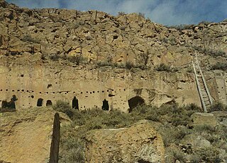
The Puye Cliff Dwellings are the ruins of an abandoned pueblo, located in Santa Clara Canyon on Santa Clara Pueblo land near Española, New Mexico. The site was declared a National Historic Landmark in 1966.

Pueblo Bonito is the largest and best-known great house in Chaco Culture National Historical Park, northern New Mexico. It was built by the Ancestral Puebloans who occupied the structure between AD 828 and 1126.
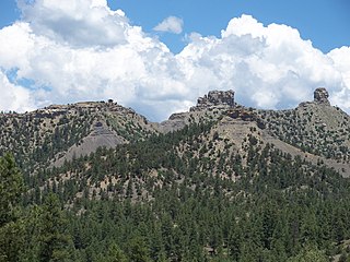
Chimney Rock National Monument is a 4,726-acre (1,913 ha) U.S. National Monument in San Juan National Forest in southwestern Colorado which includes an archaeological site. This area is located in Archuleta County, Colorado between Durango and Pagosa Springs and is managed for archaeological protection, public interpretation, and education. The Chimney Rock Archaeological Site has been listed on the National Register of Historic Places since 1970. U.S. President Barack Obama created Chimney Rock National Monument by proclamation on September 21, 2012 under authority of the Antiquities Act.

Salmon Ruins is an ancient Chacoan and Pueblo site located in the northwest corner of New Mexico, USA. Salmon was constructed by migrants from Chaco Canyon around 1090 CE, with 275 to 300 original rooms spread across three stories, an elevated tower kiva in its central portion, and a great kiva in its plaza. Subsequent use by local Middle San Juan people resulted in extensive modifications to the original building, with the reuse of hundreds of rooms, division of many of the original large, Chacoan rooms into smaller rooms, and emplacement of more than 20 small kivas into pueblo rooms and plaza areas. The site was occupied by ancient Ancestral Puebloans until the 1280s, when much of the site was destroyed by fire and abandoned. The pueblo is situated on the north bank of the San Juan River, just to the west of the modern town of Bloomfield, New Mexico, and about 45 miles (72 km) north of Pueblo Bonito in Chaco Canyon. The site was built on the first alluvial terrace above the San Juan River floodplain.

Anasazi Heritage Center, located in Dolores, Colorado, is an archaeological museum of Native American pueblo and hunter-gatherer cultures. Two 12th-century archaeological sites, the Escalante and Dominguez Pueblos, at the center were once home to Ancient Pueblo Peoples. The museum's permanent and special exhibits display some of its 3 million artifacts and information it owns of native pueblo and other regional native people. The center offers a research library, educational resources and museum shop. Wheelchair-accessible facilities include a picnic area and nature trail.

The Ansel Hall Ruin, also known as Cahone Ruin, is located in Cahone, Dolores County, Colorado. A pre-historic ruins from the Pueblo II period, the Northern San Juan pueblo was added to the National Register of Historic Places in 1997.
Sapawe or Sepawe is a Tewa Pueblo ancestral site in an address-restricted area near El Rito, New Mexico. It was occupied from around 1350 until around 1550.
Howiri is a Tewa Pueblo ancestral site in Taos County, New Mexico, United States. Its ten circular kivas are located on the east bank of Rio Ojo Caliente, near Homayo. It was occupied from around 1400 until around 1525. In 1983, it was listed on the National Register of Historic Places listings in Taos County, New Mexico.
Homayo is one of the principal Tewa Pueblo ancestral sites in New Mexico, US. Located on the west bank of the Rio Ojo Caliente, there are seven kivas. It is a large, compactly built pueblo ruin situated on a promontory on the west side of the river about a 1.5 miles (2.4 km) above Posege. The walls are of adobe about 1 foot (0.30 m). The kivas vary from 30–50 feet (9.1–15.2 m) in diameter and are all of the circular form. The village was well situated for defense, as it can be approached readily from the west side only. There is one main plaza or court which appears completely closed. Attached to this on the east are two sections which partially enclose another and smaller court. Three detached sections stand at a little distance from the main quadrangle.
Posege is one of the principal Tewa Pueblo ancestral sites in New Mexico, US. Located on the banks of the Rio Ojo Caliente at the site of Ojo Caliente, there were 13 kivas, and a population of approximately 2,000.
Fesere is one of the principal Tewa Pueblo ancestral sites in New Mexico, US. The prehistoric pueblo is situated on a mesa west or south of the Rio Chama, near Abiquiu, Rio Arriba County.
Teeuinge is one of the principal Tewa Pueblo ancestral sites in New Mexico, US. It is situated in the southerly angle formed by the juncture of Rio Oso and Rio Chama. The site measures approximately 525 feet (160 m) by 210 feet (64 m). It is a large ruin situated on the rim of the mesa overlooking the valley, just below the confluence of the two rivers. It is about .25 miles (0.40 km) south of the river, and the bluff on which it stands is about 200 feet (61 m). The pueblo was constructed of adobe with some use of lava blocks in the foundation walls, and is now reduced to low mounds. It was built in two large adjoining quadrangles, or as one long rectangle divided by cross walls into two courts. The walls have a perimeter of 1,470 feet (450 m). Within and contiguous to the pueblo are ten circular, subterranean kivas. A few yards to the east is a ruined shrine in circular form, 8 feet (2.4 m) in diameter, built of lava blocks set on edge.

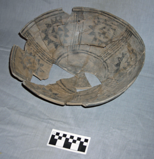
The Pueblo II Period was the second pueblo period of the Ancestral Puebloans of the Four Corners region of the American southwest. During this period people lived in dwellings made of stone and mortar, enjoyed communal activities in kivas, built towers and water conversing dams, and implemented milling bins for processing maize. Communities with low-yield farms traded pottery with other settlements for maize.

Indigenous peoples of the North American Southwest refers to the area identified with the current states of Colorado, Arizona, New Mexico, Utah, and Nevada in the western United States, and the states of Sonora and Chihuahua in northern Mexico. An often quoted statement from Erik Reed (1964) defined the Greater Southwest culture area as extending north to south from Durango, Mexico to Durango, Colorado and east to west from Las Vegas, Nevada to Las Vegas, New Mexico. Other names sometimes used to define the region include "American Southwest", "North Mexico", "Chichimeca", and "Oasisamerica/Aridoamerica".This region has long been occupied by hunter-gatherers and agricultural people.