
Heathcote National Park is a protected national park that is located in the southern region of Sydney, New South Wales in eastern Australia, and is situated on Dharawal country. The 2,679-hectare (6,620-acre) national park is situated approximately 35 kilometres (22 mi) southwest of the Sydney central business district, west of the South Coast railway line, the Princes Highway and Motorway, and the suburbs of Heathcote and Waterfall.

Burleigh Head is a small national park at Burleigh Heads in the City of Gold Coast in South East Queensland, Australia.

D'Aguilar National Park is a national park in Queensland, Australia. It contains the D'Aguilar Range and is located along the northwest of the Brisbane metropolitan area. The park is traversed by the winding scenic Mount Nebo Road and Mount Glorious Road.

Leadbeater's possum is a critically endangered possum largely restricted to small pockets of alpine ash, mountain ash, and snow gum forests in the Central Highlands of Victoria, Australia, north-east of Melbourne. It is primitive, relict, and non-gliding, and, as the only species in the petaurid genus Gymnobelideus, represents an ancestral form. Formerly, Leadbeater's possums were moderately common within the very small areas they inhabited; their requirement for year-round food supplies and tree-holes to take refuge in during the day restricts them to mixed-age wet sclerophyll forest with a dense mid-story of Acacia. The species was named in 1867 after John Leadbeater, the then taxidermist at the Museum Victoria. They also go by the common name of fairy possum. On 2 March 1971, the State of Victoria made the Leadbeater's possum its faunal emblem.

The mountain pygmy possum ; also simply known as the Burramys, is a small, mouse-sized nocturnal marsupial of Australia found in dense alpine rock screes and boulder fields, mainly southern Victoria and around Mount Kosciuszko in Kosciuszko National Park in New South Wales at elevations from 1,300 to 2,230 metres. At almost 14 cm (5.5 in), its prehensile tail is longer than its 11 cm (4.3 in) combined head and body length. Its diet consists of insects, fleshy fruits, nuts, nectar and seeds. Its body is covered in a thick coat of fine grey fur except for its stomach, which is cream coloured; its tail is hairless. On the underside of the female's body is a pouch containing four teats. This possum is the only extant species in the genus Burramys. It is also the only Australian mammal restricted to alpine habitat.

The Maribyrnong River is a perennial river of the Port Phillip catchment, located in the north–western suburbs of Melbourne, in the Australian state of Victoria.
The Wollemi Creek, a partly perennial stream of the Hawkesbury-Nepean catchment, is located in the Central Tablelands and Blue Mountains regions of New South Wales, Australia.

Quantico Creek is a 13.7-mile-long (22.0 km) partially tidal tributary of the Potomac River in eastern Prince William County, Virginia. Quantico Creek rises southeast of Independent Hill, flows through Prince William Forest Park and Dumfries and empties into the Potomac at Possum Point.

Manchester Township is one of fourteen townships in Dearborn County, Indiana. As of the 2010 census, its population was 3,215 and it contained 1,233 housing units.

Moggill Creek is a creek in Brisbane, the largest city in Queensland, Australia. The creek rises on the Taylor Range and runs in a south-easterly direction from the southern edge of Brisbane Forest Park in Kholo and Pullenvale, flowing through Upper Brookfield, Brookfield and joining the Brisbane River at Kenmore. Before entering the Brisbane River the creek is crossed by Moggill Road and winds through Rafting Ground Reserve.

Summit Township is a township in Chautauqua County, Kansas, USA. As of the 2000 census, its population was 106.
Monjebup Reserve is a 20.63 km2 nature reserve in south-west Western Australia. It is 140 km north-east of Albany, 340 km west of Esperance and 430 km south-east of Perth. It is owned and managed by Bush Heritage Australia (BHA), by which 9.56 km2 of it was purchased in 2005, with another 11.07 km2 in 2010, and forms part of BHA's Gondwana Link project.

Village Creek State Park is a state park in the Piney Woods of eastern Texas in the Hardin County city of Lumberton. The heavily forested, 1,090 acres (441 ha) park opened in 1994. It is named for Village Creek, a clean, sand-bottomed, free-flowing tributary of the Neches River.
"Stranger in Possum Meadows" is the fifty-second episode (the seventeenth episode of the third season of the television series The Twilight Zone.

Established in 1965, the Yellingbo Nature Conservation Reserve is located 45 km east of Melbourne in the Upper Yarra Valley, near the towns of Yellingbo, Launching Place, Yarra Junction, Hoddles Creek, Cockatoo, Emerald, Monbulk and Seville. Yellingbo Nature Conservation Reserve is a narrow riparian reserve with stream-frontage land along the Woori Yallock, Shepherd, Cockatoo, Macclesfield and Sheep Station Creeks.
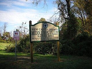
Middle Run Valley Natural Area is a nature park owned and maintained by New Castle County, Delaware, in the United States. The park, known also by its initials MRVNA, is located east of downtown Newark amidst residential neighborhoods and other park land. Establishment of MRVNA was begun in 1975; eventually the park reached its current 850 acres (3.4 km2) of forests, fields, creeks, and ponds. The most important of the creeks is Middle Run, which is a tributary of White Clay Creek, and flows mainly north to south through the park. The John C. Vansant House is located in the Middle Run Valley Natural Area.

The Toolangi State Forest region in southern Australia extends from Mount Monda in the south up to Murrindindi in the north and includes the township of Toolangi. The forest is mainly eucalypt forest that has regrown from the 1939 Victoria Bushfires.

The Ward River is a river located in Far North Queensland, Australia.
Possum Walk Creek may refer to:
