The postal service was linked to France during the colonization, who began in Mayotte in the 1840s. Successively, Mayotte's inhabitants and of Anjouan, Grande Comore et Mohéli used stamps specific to each of these islands. In 1912, the archipelago was administratively and postally united to the colony of Madagascar.
From 1950, the four Comorian islands were given stamps labelled "Archipel des Comores". After the independence of three of the Comoros islands in 1975, two services existed: the Comorian and the French post in Mayotte, whose inhabitants refused independence by referendum.
Before the joining to Madagascar in 1911
1-centime stamp of Anjouan, 1892.5-centime stamp of Grand Comoro, 1897.2-centime from the Group series of Mohéli, 1906.
A very few numbers of letters posted before 1900 in the Comoros are known. The oldest came from Mayotte in December 1850 and do not bear a postage stamp.
Mayotte became a French colony at the beginning of the 1840s after commander Passot bought it to sultan Andriantsouly.
The first stamps from the Imperial Eagle series, common to all French colonies, are sent late 1861-start 1862. They were dispatched between Mayotte and Nosy Be, a northern Madagascar island. The oldest known stamped letter from Mayotte is dated December 1863.
When the French influence extended to Mohéli, Grande Comore and Anjouan, the Frenchmen must have used the postal service based in Mayotte. Eagle stamps and French stamps (non perforated in the colonies) were certainly used. But, on the datestamp, it was always written "Mayotte and dependencies" (Mayotte et dépendances). Unless the address of the sender or the letter can give hints, it is impossible to recognize the real origin of a Comorian letter of that time. Until the 1870s, the postage stamp itself was cancelled with rhombus of points with a hole in the middle; it is impossible to know where an unstuck stamp was used.
Following excess by French adventurer Léon Humblot against Comorian people, the French Navy intervened in the archipelago and imposed the French administration. Mayotte was kept at the center of the new organisation.
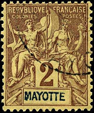
Progressively, like all French colonies, each island received stamps with its name: the postal administration was victim of a stamp traffic between low-valued currency colonies and high-valued currency colonies. Mayotte and the "sultanat d'Anjouan" received them in November 1892, Grande Comore in November 1897 and Mohéli in 1906. Twenty values were issued in Mayotte, Nineteen in Anjouan and Grande Comore, sixteen in Mohéli.
From Madagascar to the Comoros Archipelago (1911–1975)
2 centimes stamp of Grand Comoro overprinted in 1912.
After the decision to unite Comoros to the Madagascar colony, the postal fusion is effective in 1912. The remaining stamps are overprinted with big black and red "05" and "10" to serve at small values of five and ten centimes. All post offices of the former colonies linked now to Madagascar did the same; overprinted stamps were accepted every where in the colony.
From 1912 to 1950, Madagascar stamps are used in the Comoros. Collectors look for the place of cancellation to find Comorian items.
The situation changed in 1946 when the archipelago was no more a colony, but an oversea territory of France: specific stamps are issued on 15 May 1950 printed "Archipel des Comores" with value in CFA franc. The first series showed local landscapes. Aquatic fauna and flora of the Comoros, traditions, arts and crafts constituted the most part of the philatelic program, with the French colonies' omnibus issues.
The first person to be honored by a Comoros Archipelago stamps was Charles de Gaulle in 1971, using two of the Metropolitan French series. Then, international scientists and artists are commemorated between 1972 and 1973. Finally, two local personalities appeared: president Said Mohamed Cheikh (died 1970) on two 1973 stamps and Saïd Omar ben Soumeth, Comoros' grand mufti in 1974.
Since Independence in 1975
Following the 1974 referendums, the Comorian Parliament voted for independence on 5 July 1975. The postage stamp stocks were in Moroni on Grande Comore. They were overprinted to strike mentions of French sovereignty and to add "État comorien" (Comorian State).
In 1976 and 1977, under President Ali Soilih, Comoros underwent a philatelic issue frenzy: within these two years, the country had issued more stamps than during all the years of the Comorian Archipelago (1946–1975). Moreover, few of these stamps concerned local topics. New topics included space exploration, Winter Olympic Games, etc.
Between 1997 and 2000, secessionist events occurred on Anjouan and Mohéli islands which were finally resolved with the creation of the Union of Comoros.
Symbols of the flag of Anjouan were used on stamps and labels between 1997 and 2001.
On Anjouan, postage stamps may have circulated in mail. Only one revenue stamp with the map and flag of Anjouan, printed in France, served on a legal document.
End 1997-beginning 1998, French philatelic magazines reported[2] a message announcing the opening of a private postal service between Anjouan and French-controlled Mayotte. The stamp used on the received letters (map and symbols of Anjouan, and the flag of France) represented the cost of the transport by dhow between the islands. In Mayotte, a French stamp was added and put in a French post box. However, it seems no proof of real service exists.[3]
The Comoros, officially the Union of the Comoros, is an archipelagic country made up of three islands in Southeastern Africa, located at the northern end of the Mozambique Channel in the Indian Ocean. Its capital and largest city is Moroni. The religion of the majority of the population, and the official state religion, is Sunni Islam. Comoros proclaimed its independence from France on 6 July 1975. A member of the Arab League, it is the only country in the Arab world which is entirely in the Southern Hemisphere. It is a member state of the African Union, the Organisation internationale de la Francophonie, the Organisation of Islamic Co-operation, and the Indian Ocean Commission. The country has three official languages: Shikomori, French and Arabic.
The history of the Comoros extends to about 800–1000 AD when the archipelago was first inhabited. The Comoros have been inhabited by various groups throughout this time. France colonised the islands in the 19th century, and they became independent in 1975.
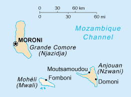
The Comoros archipelago consists of four main islands aligned along a northwest–southeast axis at the north end of the Mozambique Channel, between Mozambique and the island of Madagascar. Still widely known by their French names, the islands officially have been called by their Swahili names by the Comorian government. They are Grande Comore (Njazidja), Mohéli (Mwali), Anjouan (Nzwani), and Mayotte (Mahoré). The islands' distance from each other—Grande Comore is some 200 kilometers from Mayotte, forty kilometers from Mohéli, and eighty kilometers from Anjouan—along with a lack of good harbor facilities, make transportation and communication difficult. Comoros are sunny islands.
Mayotte, officially the Department of Mayotte, is an overseas department and region and single territorial collectivity of France. It is located in the northern part of the Mozambique Channel in the Indian Ocean off the coast of Southeastern Africa, between Northwestern Madagascar and Northeastern Mozambique. Mayotte consists of a main island, Grande-Terre, a smaller island, Petite-Terre, as well as several islets around these two. Mayotte is the most prosperous territory in the Mozambique Channel, making it a major destination for immigration.
Anjouan is an autonomous volcanic island in the Comoro Islands in the southwestern Indian Ocean, part of the Union of the Comoros. It is known in Shikomori as Ndzuani, Ndzuwani or Nzwani, and, until the early twentieth century when the name fell out of general use, in English as Johanna. Historically it was also called Hinzuan or Hanzoan.
The Comoro Islands or the Comoros are an archipelago of volcanic islands situated off the southeastern coast of Africa, to the east of Mozambique and northwest of Madagascar. The islands are politically divided between the Union of the Comoros, a sovereign country, and Mayotte, an Overseas Department of France.
Mohéli, also known as Mwali, is an autonomously-governed island that forms part of the Union of the Comoros. It is the smallest of the three major islands in the country. It is located in the Indian Ocean off the coast of Africa and it is the smallest of the four major Comoro Islands. Its capital and largest city is Fomboni.
The franc is the official currency of Comoros. It is nominally subdivided into 100 centimes, although no centime denominations have ever been issued.
Each "article" in this category is in fact a collection of entries about several stamp issuers, presented in alphabetical order. The entries themselves are formulated on the micro model and so provide summary information about all known issuers.
Each "article" in this category is a collection of entries about several stamp issuers, presented in alphabetical order. The entries are formulated on the micro model and so provide summary information about all known issuers.
Each "article" in this category is a collection of entries about several stamp issuers, presented in alphabetical order. The entries are formulated on the micro model and so provide summary information about all known issuers.
This is an overview of the postage stamps and postal history of the Indian Ocean island of Mayotte, one of the Comoros Archipelago islands located on the south-east side of Africa.
The Navigation and Commerce issue is a series of key type stamps issued for the colonial territories of France. It was designed by Louis-Eugène Mouchon.
The Comoros forests is a terrestrial ecoregion which covers the Comoro Islands, which lie in the Mozambique Channel between Madagascar and East Africa. These include four main islands: Grande Comore, Anjouan and Mohéli, of the Union of the Comoros, and Mayotte, a department and region of France.
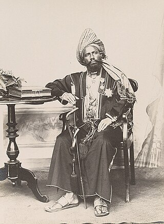
Said Ali bin Said Omar was the Sultan of Grande Comore. He was the first and last sultan tibe or paramount king of the whole island of Ngazidja.
An independence referendum was held in the Comoros on 22 December 1974. The overall result was a strong "yes" vote, with 94.57% of voters voting for independence and almost all the "no" votes being cast in Mayotte, where there was a majority for remaining under French control. In contrast, on Mohéli only five out of 6,059 votes were against independence. Voter turnout was 93.3%.
This is a survey of the postage stamps and postal history of Madagascar, briefly also known as Malagasy.
The official languages of the Comoros are Comorian, French and Arabic, as recognized under its 2001 constitution. Although each language holds equal recognition under the constitution, language use varies across Comorian society. Unofficial minority languages such as Malagasy and Swahili are also present on the island with limited usage. According to Harriet Joseph Ottenheimer, a professor of anthropology at Kansas State university, the linguistic diversity of the Comoros is the result of its rich history as part of the Indian maritime trade routes and its periods of Malagasy and French colonial rule.
Said Ali Kemal was a Comorian politician. He was the son of Prince Saïd Ibrahim Ben Ali and the grandson of Sultan Said Ali bin Said Omar of Grande Comore.
The Territory of the Comoros was a French overseas territory consisting of the four main Comoro Islands that existed from 1946 to 1975. It was part of the French Union under the Fourth Republic, then part of the French Community established by the Constitution of the Fifth Republic from 1958.
This page is based on this Wikipedia article Text is available under the CC BY-SA 4.0 license; additional terms may apply. Images, videos and audio are available under their respective licenses.