Pothong River

Last updated
39°02′02″N125°42′15″E / 39.03389°N 125.70417°E / 39.03389; 125.70417 , which supports the main east–west divided highway. [2] [3]

Prior to 1946, the arable land west of Pyongyang alongside the river (the flood plain), down to where it entered the Taedong River was subject to annual flooding. This area was known as Tosongrang. [4] The farmers there annually rebuilt their homes after the floods subsided, so the construction was, perforce, of a temporary nature, huts and even pit-houses. [5] In 1946 the river was channelized through Tosongrang as the "Pothong River Improvement Project". [1] [4] Tosongrang is now part of Pyongyang.

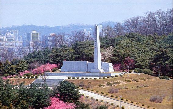
In 1971, in a park on Mount Bonghwa, [6] a hill on the left (east) bank of the river, the government erected a monument for the "Pothong River Improvement Project", 39°02′38″N125°42′34″E / 39.04389°N 125.70944°E / 39.04389; 125.70944 . [4] [7] It commemorates Kim Il Sung's 1945 visit to Tosongrang and the 1946 channelization.

In 1976 the North Korean postal service (DPRK) issued a stamp commemorating Kim Il Sung's 1945 visit to Tosongrang. [8] In 1998, they issued a stamp souvenir sheet showing Kim Il Sung breaking ground for the construction of the channelization project. [9]

Notes and references

  1. 1 2 Corfield, Justin (2014). Historical Dictionary of Pyongyang. London: Anthem Press. p.  167. ISBN   978-1-78308-341-1.
  2. The Ansan Bridge appears on a 1990 stamp, Scott #2891, label in that catalogue as "Pothong Bridge" - Scott (2008) "Korea, Democratic People’s Republic" Scott 2009 Standard Postage Stamp Catalogue Volume 4 (165th edition) Scott Publishing Co., Sidney, Ohio, page 303. ISBN   978-0-89487-420-8
  3. See map at http://www.pyongyang-metro.com/pystrtmp.jpeg Archived 2016-03-05 at the Wayback Machine
  4. 1 2 3 "Ufergebiet des Flusses Pothonggang" [The Banks of the Potong River] (in German). Nordkorea-Information. Archived from the original on 19 January 2016.
  5. Some authors referred to it as a slum. Springer, Chris (2003). Pyongyang: The Hidden History of the North Korean Capital. Budapest: Entente Bt. ISBN   978-963-00-8104-7.; Han, Myŏng-ho (1994). Kim Il Sung: The Great Man of the Century (PDF). Pyongyang: Foreign Languages Publishing House. OCLC   30886237.
  6. The park is sometimes known as "Potong River Pleasure Ground".
  7. "Pothong River Improvement Project". Geoview (Lutz Harder).
  8. Scott #1533 - Scott (2008), page 276.
  9. Scott #3790 - Scott (2008), page 326.

Related Research Articles

<span class="mw-page-title-main">Pyongyang</span> Capital of North Korea

Pyongyang is the capital and largest city of North Korea, where it is sometimes labeled as the "Capital of the Revolution". Pyongyang is located on the Taedong River about 109 km (68 mi) upstream from its mouth on the Yellow Sea. According to the 2008 population census, it has a population of 3,255,288. Pyongyang is a directly administered city with a status equal to that of the North Korean provinces.

<span class="mw-page-title-main">Taedong River</span> River in North Korea

The Taedong River (Korean: 대동강) is a large river in North Korea. The river rises in the Rangrim Mountains of the country's north where it then flows southwest into Korea Bay at Namp'o. In between, it runs through the country's capital, Pyongyang. Along the river are landmarks such as the Juche Tower and Kim Il-sung Square.

<span class="mw-page-title-main">Kim Chaek University of Technology</span> University in North Korea

Kim Chaek University of Technology is a university in North Korea, on the banks of the Taedong River in Pyongyang. It is named after General Kim Chaek.

<span class="mw-page-title-main">Kim Il Sung Stadium</span> Stadium in Pyongyang, North Korea

Kim Il Sung Stadium (Korean: 김일성경기장) is a multi-purpose stadium located in Pyongyang, the capital city of North Korea. The stadium is used primarily for association football matches.

<span class="mw-page-title-main">Moranbong</span> Hilly park in Pyongyang, North Korea

Moranbong or Moran Hill forms a park located in central Pyongyang, the capital of North Korea. Its 312-foot (95 m) summit is the location of the Pyongyang TV Tower.

<span class="mw-page-title-main">Chung-guyok</span> District of Pyongyang, North Korea

Chung-guyok is one of the 19 guyok which constitute the city of Pyongyang, North Korea. The district is located in the center of the city, between the Pothonggang Canal and Taedong River, and is bordered to the north by Moranbong-guyok, to the northwest by Potonggang-guyok, and to the south by Pyongchon-guyok.

<span class="mw-page-title-main">Pyongchon-guyok</span> District of Pyongyang, North Korea

P'yŏngch'ŏn-guyŏk is one of the 18 guyŏk of P'yŏngyang, North Korea. It is bordered by the Taedong River in the south and the Pothonggang Canal in the north and Potong River in the west, and to the east by Chung-guyŏk, from which it is separated by the yard area of P'yŏngyang railway station.

<span class="mw-page-title-main">Potonggang-guyok</span> Guyŏk of Pyongyang in Pyŏngyang-Chikhalsi, North Korea

Potonggang-guyok is one of the 18 districts, or guyok, of Pyongyang, North Korea. It is most famous as the location of the Ryugyong Hotel. It is named after the Pothong River, which serves as the district's border on all sides. It is bordered to the north by Hyongjesan-guyok, to the east by Sosong and Moranbong-guyoks, to the south by Pyongchon and Chung-guyoks, and to the west by Mangyongdae-guyok. The district was established by the Pyongyang City People's Committee in October 1960.

<span class="mw-page-title-main">Moranbong-guyok</span> District of Pyongyang, North Korea

Moranbong-guyŏk (Korean: 모란봉구역), or the Moranbong District, is one of the 18 guyŏk which constitute the capital city of Pyongyang, North Korea. It is located north of Chung-guyok, the city's central district, and is bordered to the north by Sosong and Taesong-guyoks, to the east by the Taedong River, and the west by the Pothonggang Canal and Potonggang-guyok. It is named after Moran Hill, located in the district's west area – Moran. It was designated a guyŏk in October 1960 by the Pyongyang City People's Committee.

<span class="mw-page-title-main">Kim Il Sung Square</span> City square in Pyongyang, North Korea


Kim Il Sung Square is a large city square in the Central District of Pyongyang, North Korea, and is named after the country's founding leader, Kim Il Sung. The square was constructed in 1954 according to a master plan for reconstructing the capital after the destruction of the Korean War. It was opened in August 1954. The square is located on the foot of the Namsan Hill, west bank of the Taedong River, directly opposite the Juche Tower on the other side of the river. It is the 37th largest square in the world, having an area of about 75,000 square metres which can accommodate a rally of more than 100,000 people. The square has a great cultural significance, as it is a common gathering place for concerts, rallies, dances and military parades and is often featured in media concerning North Korea.

<span class="mw-page-title-main">Pyongyang Marathon</span> Annual race held in Pyongyang, North Korea

Pyongyang International Marathon, previously known as Mangyongdae Prize International Marathon, is an annual marathon race contested each April in Pyongyang, the capital of North Korea.

<span class="mw-page-title-main">Ryongwang Pavilion</span> Pavilion in Pyongyang, North Korea

Ryongwang Pavilion is a scenic overlook located in the central district of Pyongyang, North Korea. Located on the bank of the Taedong River, the pavilion was first constructed during the Goguryeo dynasty as "Sansu Pavilion", and was part of the defenses of the walled city of Pyongyang. It is labeled as National Treasure #16 in North Korea.

<span class="mw-page-title-main">Grand People's Study House</span> Large library in Pyongyang

The Grand People's Study House is the central library located in the North Korean capital, Pyongyang. The building is situated on Kim Il Sung Square by the banks of the Taedong River.

<span class="mw-page-title-main">Ongryu Bridge</span> Road bridge in Pyongyang, North Korea

Ongryu Bridge, also spelled Okryu Bridge and Ongnyu Bridge, is a bridge on the Taedong River in and near Pyongyang, North Korea. Construction began in March 1958; the bridge was opened in August 1960.

<span class="mw-page-title-main">Rungra Bridge</span> Bridge in Pyongyang, North Korea

The Rungra Bridge is a bridge in Pyongyang, North Korea, one of the city's six bridges on the Taedong River. Located between the Okryu Bridge to the south and Chongryu Bridge to the north, it connects Moranbong-guyok on the right (west) bank of the Taedong River with Taedonggang-guyok on the left bank, passing through Rungra Island in the middle. It totals 1,070 metres (3,510 ft) in length. It was completed in 1988.

Kangdong Residence is the summer retreat and second major residence of the North Korean leader Kim Jong Un besides Ryongsong Residence.

<span class="mw-page-title-main">Korean Central History Museum</span> History museum in Pyongyang, North Korea

The Korean Central History Museum is a museum located in Pyongyang, North Korea. The museum is located at the north end of Kim Il-sung Square. It contains displays on Korean history from primitive society to the modern age.

<span class="mw-page-title-main">Taedong Bridge</span> Bridge in Pyongyang, North Korea

The Taedong Bridge (Korean: 대동교) is a bridge over the Taedong River in Pyongyang, North Korea.

<span class="mw-page-title-main">Pothonggang Canal</span> Canal in Pyongyang, North Korea

The Pothonggang Canal is a river in North Korea. It flows through the capital Pyongyang and is a tributary of the Pothong River. Prior to 1946, the canal was part of the Pothong River. That year, the Pothong River Improvement Project separated the Canal.

<i>Our Construction</i> 1946 first North Korean film

Our Construction is a North Korean documentary that was created in 1946. It is widely considered to be the first North Korean film, and predates the 1949 My Home Village, which was the first feature film in the country. It is a silent and black-and-white film.

Pothong River
Pothong River.jpg