Praia Grande (Ferragudo)

Last updated
Big Beach
Ferragudo1.jpg
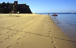
A view of the golden sand of Praia Grande near the Fort of São João do Arade
Portugal location map.svg
Red pog.svg
Location of Praia Grande within the municipality of Lagoa
Location Lagoa, Algarve, Portugal
Coordinates 37°7′12″N8°31′20″W / 37.12000°N 8.52222°W / 37.12000; -8.52222 Coordinates: 37°7′12″N8°31′20″W / 37.12000°N 8.52222°W / 37.12000; -8.52222
GeologyBeach

Praia Grande (Big Beach) is a beach situated in the civil parish of Ferragudo, municipality of Lagoa, the Portuguese Algarve.

Ferragudo Civil parish in Algarve, Portugal

Ferragudo is a Portuguese civil parish at the western border of the municipality of Lagoa. The population in 2011 was 1,973, in an area of 5.41 km². Ferragudo serves mainly as a bedroom community for its much larger neighbour, the city of Portimão; its residents routinely travel across the Arade River to work in the neighboring municipality.

Concelho, is the Portuguese-language term for municipality, referring to the territorial division. In comparison, the word município refers to the organs of State. This differentiation is still in use in Portugal and some of its former overseas provinces, but is no longer in use in Brazil following the abolition of these organs, in favour of the French prefecture system.

Portugal Republic in Southwestern Europe

Portugal, officially the Portuguese Republic, is a country located mostly on the Iberian Peninsula in southwestern Europe. It is the westernmost sovereign state of mainland Europe, being bordered to the west and south by the Atlantic Ocean and to the north and east by Spain. Its territory also includes the Atlantic archipelagos of the Azores and Madeira, both autonomous regions with their own regional governments.

One of many beaches to obtain the name Praia Grande, this coastal zone is located on the eastern back of Rio Arade estuary, south of the town of Ferragudo. [1] It is just inside the mole that shields the river entrance and the port area of Portimão, and runs north to the Forte de Sao João do Arade. [1] The crescent-shaped 627 metres (2,057 ft)-long beach extends from the accessway, at the end of Rua Doutor Coelho de Carvalho southeast to the cliffs, with a smaller beach extending 163 metres (535 ft) north to the summit of the fort, separated by boulders.

Estuary A partially enclosed coastal body of brackish water with one or more rivers or streams flowing into it, and with a free connection to the open sea

An estuary is a partially enclosed coastal body of brackish water with one or more rivers or streams flowing into it, and with a free connection to the open sea.

Mole (architecture) massive structure used as pier, breakwater, or causeway between places separated by water

A mole is a massive structure, usually of stone, used as a pier, breakwater, or a causeway between places separated by water. The word comes from Middle French mole, ultimately from Latin mōlēs, meaning a large mass, especially of rock; it has the same root as molecule and mole, the chemical unit of measurement. A mole may have a wooden structure built on top of it that resembles a wooden pier. The defining feature of a mole, however, is that water cannot freely flow underneath it, unlike a true pier. The oldest known mole is at Wadi al-Jarf, an ancient Egyptian harbor complex on the Red Sea.

Portimão Municipality in Algarve, Portugal

Portimão is a town and a municipality in the district of Faro, in the Algarve region of southern Portugal. The population in 2011 was 55,614, in an area of 182.06 km². It was formerly known as Vila Nova de Portimão. In 1924, it was incorporated as a cidade and became known merely as Portimão. Historically a fishing and shipbuilding centre, it has nonetheless developed into a strong tourist centre oriented along its beaches and southern coast. The two most populous towns in the Algarve are Portimão and Faro.

Like other beaches in the western Algarve, it is bordered by cliffs from the Miocene epoch, that are rich in marine fossils.

Algarve Region in Portugal

The Algarve is the southernmost region of continental Portugal. It has an area of 4,997 km2 (1,929 sq mi) with 451,006 permanent inhabitants, and incorporates 16 municipalities. The region has as its administrative centre in the city of Faro, where both the region's international airport (FAO) and public university, the University of Algarve, are located. Tourism and related activities are extensive and make up the bulk of the Algarve's summer economy. Production of food, which includes fish and other seafood, different types of fruit such as oranges, figs, plums, carob beans, and almonds, is also economically important in the region. Although Lisbon surpasses the Algarve in terms of tourism revenue, the Algarve is still, overall, considered to be the biggest and most important Portuguese tourist region, having received an estimated total of 7.1 million tourists in 2017. Its population triples in the peak holiday season due to seasonal residents. The Algarve is also increasingly sought after, mostly by central and northern Europeans, as a permanent place to settle. A 2016 American-based study concluded that the Algarve was the world's best place to retire.

The Miocene is the first geological epoch of the Neogene Period and extends from about 23.03 to 5.333 million years ago (Ma). The Miocene was named by Charles Lyell; its name comes from the Greek words μείων and καινός and means "less recent" because it has 18% fewer modern sea invertebrates than the Pliocene. The Miocene is preceded by the Oligocene and is followed by the Pliocene.

Fossil Preserved remains or traces of organisms from a past geological age

A fossil is any preserved remains, impression, or trace of any once-living thing from a past geological age. Examples include bones, shells, exoskeletons, stone imprints of animals or microbes, objects preserved in amber, hair, petrified wood, oil, coal, and DNA remnants. The totality of fossils is known as the fossil record.

With median temperatures between 20–22 °C (68–72 °F), its protected location within the mole permits swimming/wading, windsurfing, bodyboard and sailing. [1]

The municipal authority services the beach with outdoor parking, security/surveillance, changing areas and showers, while commercial services include bar/restaurants, sunshade rentals and small craft hire. [1]

Related Research Articles

Praia Grande may refer to:

Lagoa, Algarve Municipality in Algarve, Portugal

Lagoa is a town in the former-district of Faro, in the Portuguese region of the Algarve. The population in 2011 was 22,975, in an area of 88.25 km². Its urban population is 6100 inhabitants.

Praia da Luz Civil parish in Algarve, Portugal

Praia da Luz, officially Luz, is a civil parish located about 6 kilometres (3.7 mi) from the municipality of Lagos in the Algarve, Portugal. The population in 2011 was 3,545, in an area of 21.78 km². Also known as Luz de Lagos or Vila da Luz, "Praia da Luz" is used to refer to both the urbanized village and the beach. The parish had its origins in a small fishing village, but was transformed by several holiday-villa complexes into a tourist area.

Arade River river in Portugal

The Arade is a river located in the region of the Algarve, southern Portugal. the river's course takes it through the municipalities of Silves, Lagoa and Portimão. The source of the river lies to the southwest of the Serra do Caldeirão mountain ridge, in a valley called Barranco do Pé do Coelho. The river has a total length of 75.0 kilometres (46.6 mi), with its source being 481 metres (1,578 ft) above sea level. The mouth of the river empties into the Atlantic Ocean between the city of Portimão and the freguesia of Ferragudo, in Lagoa Municipality.

Fort of São João do Arade building in Ferragudo, Faro District, Portugal

The Fort of São João do Arade, sometimes referred to as the Castle of Arade, is a medieval fortification situated in the civil parish of Ferragudo in the Portuguese Algarve municipality of Lagoa.

Praia da Angrinha (Ferragudo)

Praia da Angrinha is situated along the wide estuary of the Arade River, south of Ferragudo, in Lagoa Municipality.

Fort of Santa Catarina (Portimão) building in Portimãeso, Faro District, Portugal

The Fort of Santa Catarina is a medieval fort situated in the civil parish of Portimão, in the municipality of Portimão in Portuguese Algarve. The structure was considered one of the last Philippine military projects in the Algarve, erected to defend the peninsula from pirates and privateers, as well as military invasions. Its construction is one of the better examples that work of Alexandre Massai, a military engineer who toured the Algarve to reinforce numerous military fortifications along the coast.

Praia de Odeceixe Mar

Praia de Odeceixeis is a beach and small settlement within the Municipality of Aljezur, in the Algarve, Portugal. The beach is on the western seaboard in the extreme north west of the Algarve. It is in the Vicentine Coast Natural Park. The beach is 2.1 miles (3.4 km) west of the village of Odeceixe, and is 77.9 miles (125.4 km) north west, by road, from the region's capital of Faro. In 2012 Praia de Odeceixe was designated a blue Flag beach.

Praia da Arrifana

Praia da Arrifana is a beach within the Municipality of Aljezur, in the Algarve, Portugal. The beach is on the western Seaboard in the north west of the Algarve. The beach is 6.0 miles (9.7 km) south south west of the village of Aljezur, and is 71.0 miles (114.3 km) north west, by road, from the regions capital of Faro. The beach of Praia da Arrifana is inside the Vicentine Coast Natural Park, an area of outstanding natural beauty. Praia da Arrifana has been designated a blue Flag beach (2012).

Praia da Pipa

Praia da Pipa is a beach within the Municipality of Aljezur, in the Algarve, Portugal. The beach is on the western Seaboard in the north west of the Algarve. The beach is 6.8 miles (10.9 km) south south west of the village of Aljezur, and is 71.7 miles (115.4 km) north west, by road, from the regions capital of Faro. The beach of Praia da Pipa is inside the Vicentine Coast Natural Park, an area of outstanding natural beauty.

Praia do Penedo

Praia do Penedo is a beach within the Municipality of Aljezur, in the Algarve, Portugal. The beach is on the western Seaboard in the north west of the Algarve. The beach is 6.7 miles (10.8 km) south west of the village of Aljezur, and is 65.6 miles (105.6 km) north west, by road, from the regions capital of Faro. The beach of Praia do Penedo is inside the Vicentine Coast Natural Park, an area of outstanding natural beauty.

Praia de Vale Figueira

Praia de Vale Figueira is a beach within the Municipality of Aljezur, in the Algarve, Portugal. The beach is on the western Seaboard in the north west of the Algarve. The beach is 9.1 miles (14.6 km) south west of the village of Aljezur, and is 66.6 miles (107.2 km) north west, by road, from the regions capital of Faro. The beach of Praia de Vale Figueira is inside the Vicentine Coast Natural Park, an area of outstanding natural beauty.

Praia de São Rafael

Praia de São Rafael is a beach on the Atlantic south coast of the Algarve, close to the village resort of Sesmarias which is within the Municipality of Albufeira, Portugal. This beach is located 2.5 miles (4.0 km) by road to the west of Albufeira old town centre and is 29.7 miles (47.8 km) west of the regions capital of Faro. This beach is one of sixty nine blue flag beaches (2012) in the Algarve and is accredited with good facilities for the disabled.

Praia dos Arrifes

Praia dos Arrifes is a beach on the Atlantic south coast of the Algarve, close to the village resort of Sesmarias which is within the Municipality of Albufeira, Portugal. This beach is located 2.4 miles (3.9 km) by road to the west of Albufeira old town centre and is 29.6 miles (47.6 km) west of the regions capital of Faro. This beach is one of sixty nine blue flag beaches (2012) in the Algarve

Praia do Castelo

Praia do Castelo is a beach close to the village resort of Sesmarias which is within the Municipality of Albufeira, in the Algarve, Portugal. This beach is located 4.0 miles (6.4 km) by road to the west of Albufeira old town centre and is 31.9 miles (51.3 km) west of the regions capital of Faro. This beach is one of sixty nine blue flag beaches (2012) in the Algarve.

Praia da Oura

Praia da Oura is a blue flag beach within the Municipality of Albufeira, in the Algarve, Portugal. The beach is in the eastern district of Albufeira in the neighbourhood called Areias de São João. Its flanked by Praia dos Aveiros to the west and Praia de Santa Eulália to the eastern side. The beach is approximately 900 meters in length and is 450 meters wide at low tide.

Praia dos Aveiros

Praia dos Aveiros is a small blue flag beach in the area called Areias de São João or Saint John's Sands, in the town of Albufeira, Algarve, Portugal. The beach is enclosed in a small cove and is made up of fine golden sands and is flanked at either end by cliffs and rock formations.

Praia dos Pescadores (Albufeira)

Praia dos Pescadores or the Fishermans Beach is a blue flag beach on the Atlantic south coast of the Algarve, in the district of Bairro dos Pescadores, Albufeira which is within the Municipality of Albufeira, Portugal. The beach is one of the two beaches which front the town of Albufeira with Praia do Túnel at the western end and Praia dos Pescadores lying to the eastern end of the towns seafront. The town and its beaches are located west 23.9 miles (38.5 km) by road of the regions capital of Faro.

References

  1. 1 2 3 4 Praia Grande - Ferragudo, Lisbon, Portugal: Turismo de Portugal, 2013